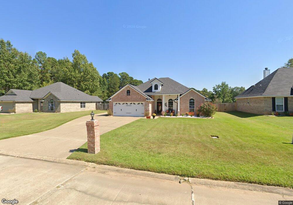
5233 Dalewood Dr Shreveport, LA 71107
Estimated Value: $188,586 - $220,000
3
Beds
2
Baths
1,513
Sq Ft
$132/Sq Ft
Est. Value
About This Home
This home is located at 5233 Dalewood Dr, Shreveport, LA 71107 and is currently estimated at $199,647, approximately $131 per square foot. 5233 Dalewood Dr is a home located in Caddo Parish with nearby schools including North Highlands Elementary School, Judson Fundamental Elementary School, and Fairfield Magnet School.
Ownership History
Date
Name
Owned For
Owner Type
Purchase Details
Closed on
May 30, 2008
Sold by
Deco Home Dreams Llc
Bought by
Kindells Roy L
Current Estimated Value
Home Financials for this Owner
Home Financials are based on the most recent Mortgage that was taken out on this home.
Original Mortgage
$12,000
Outstanding Balance
$7,637
Interest Rate
5.89%
Mortgage Type
Unknown
Estimated Equity
$192,010
Create a Home Valuation Report for This Property
The Home Valuation Report is an in-depth analysis detailing your home's value as well as a comparison with similar homes in the area
Home Values in the Area
Average Home Value in this Area
Purchase History
| Date | Buyer | Sale Price | Title Company |
|---|---|---|---|
| Kindells Roy L | $15,000 | None Available |
Source: Public Records
Mortgage History
| Date | Status | Borrower | Loan Amount |
|---|---|---|---|
| Open | Kindells Roy L | $12,000 |
Source: Public Records
Tax History Compared to Growth
Tax History
| Year | Tax Paid | Tax Assessment Tax Assessment Total Assessment is a certain percentage of the fair market value that is determined by local assessors to be the total taxable value of land and additions on the property. | Land | Improvement |
|---|---|---|---|---|
| 2024 | $2,332 | $15,768 | $1,456 | $14,312 |
| 2023 | $2,396 | $15,768 | $1,456 | $14,312 |
| 2022 | $2,396 | $15,768 | $1,456 | $14,312 |
| 2021 | $2,397 | $15,768 | $1,456 | $14,312 |
| 2020 | $2,397 | $15,768 | $1,456 | $14,312 |
| 2019 | $2,307 | $15,311 | $1,456 | $13,855 |
| 2018 | $1,214 | $15,311 | $1,456 | $13,855 |
| 2017 | $2,303 | $15,311 | $1,456 | $13,855 |
| 2015 | $1,172 | $14,850 | $1,460 | $13,390 |
| 2014 | $1,179 | $14,850 | $1,460 | $13,390 |
| 2013 | -- | $14,850 | $1,460 | $13,390 |
Source: Public Records
Map
Nearby Homes
- 5244 N Market St
- 5220 Old Mooringsport Rd
- 955 Roanoke Dr
- 5036 Asaff Ave
- 1042 N Lane Dr
- 5037 N Market St
- 5555 Old Mooringsport Rd
- 419 Irving Bluff Rd
- 434 Irving Bluff Rd
- 4685 Kent Rd
- 4687 Kent Rd
- 6095 Pine Hill Rd
- Mimosa III A Plan at Falcon Bay
- Hickory III B Plan at Falcon Bay
- Hickory III A Plan at Falcon Bay
- Cedar IV A Plan at Falcon Bay
- Camellia V A Plan at Falcon Bay
- Camellia V B Plan at Falcon Bay
- Orchid III B Plan at Falcon Bay
- Irises V B Plan at Falcon Bay
- 5239 Dalewood Dr
- 0 Dalewood Dr Unit 5 277706NL
- 0 Dalewood Dr Unit 5 223851NL
- 0 Dalewood Dr Unit 223850NL
- 0 Dalewood Dr Unit 5 207737NL
- 0 Dalewood Dr Unit 11 207627NL
- 0 Dalewood Dr
- 5217 Dalewood Dr
- 5225 Dalewood Dr
- 5245 Dalewood Dr
- 5236 Dalewood Dr
- 5226 Dalewood Dr
- 5218 Dalewood Dr
- 5244 Dalewood Dr
- 5215 Dalewood Dr
- 5240 N Market St
- 5206 Dalewood Dr
- 5265 Dalewood Dr
- 5200 Dalewood Dr
- 5211 Dalewood Dr