Estimated Value: $141,739 - $157,000
3
Beds
1
Bath
1,232
Sq Ft
$119/Sq Ft
Est. Value
About This Home
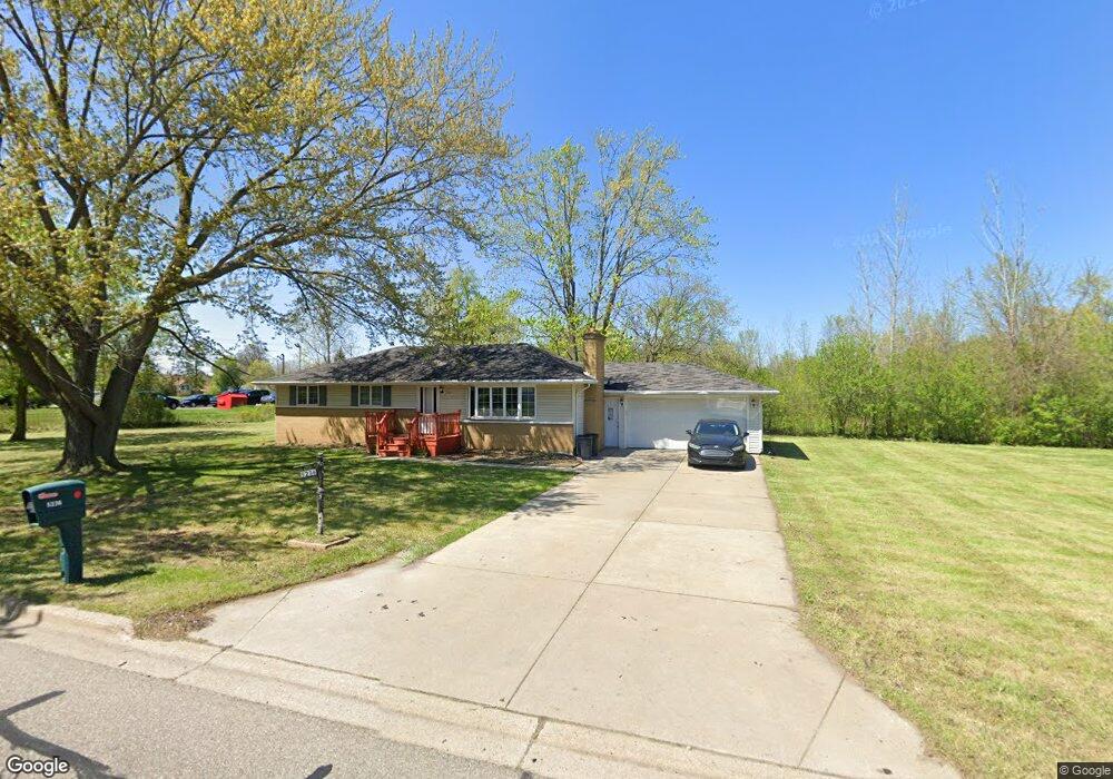
This home is located at 5236 Lennon Rd, Flint, MI 48507 and is currently estimated at $146,935, approximately $119 per square foot. 5236 Lennon Rd is a home located in Genesee County with nearby schools including Carman-Ainsworth High School and Genesee STEM Academy.
Ownership History
Date
Name
Owned For
Owner Type
Purchase Details
Closed on
Jul 13, 2018
Sold by
The Estate Of Carol Ruth Hicks
Bought by
Chen Xiang Ping
Current Estimated Value
Purchase Details
Closed on
Nov 24, 2014
Sold by
Bobb Mark W
Bought by
Hicks Carol
Purchase Details
Closed on
Aug 12, 2014
Sold by
Hicks Carol R and Hicks Ronald L
Bought by
Hicks Carol R and Bobb Mark
Purchase Details
Closed on
Aug 11, 2014
Sold by
Hicks Carol R
Bought by
Bobb Mark W
Purchase Details
Closed on
Dec 6, 2013
Sold by
Hicks Carol R and Hicks Ronald L
Bought by
Hicks Carol R and Bobb Mark
Create a Home Valuation Report for This Property
The Home Valuation Report is an in-depth analysis detailing your home's value as well as a comparison with similar homes in the area
Home Values in the Area
Average Home Value in this Area
Purchase History
| Date | Buyer | Sale Price | Title Company |
|---|---|---|---|
| Chen Xiang Ping | $80,000 | Sargents Title Co | |
| Hicks Carol | -- | Cislo Title Company | |
| Hicks Carol R | -- | None Available | |
| Bobb Mark W | $500 | Cislo Title Company | |
| Hicks Carol R | -- | None Available |
Source: Public Records
Tax History
| Year | Tax Paid | Tax Assessment Tax Assessment Total Assessment is a certain percentage of the fair market value that is determined by local assessors to be the total taxable value of land and additions on the property. | Land | Improvement |
|---|---|---|---|---|
| 2025 | $2,616 | $63,400 | $0 | $0 |
| 2024 | $2,471 | $60,300 | $0 | $0 |
| 2023 | $2,058 | $47,200 | $0 | $0 |
| 2022 | $869 | $41,400 | $0 | $0 |
| 2021 | $2,311 | $39,800 | $0 | $0 |
| 2020 | $1,407 | $38,500 | $0 | $0 |
| 2019 | $1,389 | $34,500 | $0 | $0 |
| 2018 | $1,462 | $40,000 | $0 | $0 |
| 2017 | $1,409 | $40,000 | $0 | $0 |
| 2016 | $1,771 | $34,300 | $0 | $0 |
| 2015 | $1,753 | $31,600 | $0 | $0 |
| 2014 | $715 | $30,300 | $0 | $0 |
| 2012 | -- | $33,900 | $33,900 | $0 |
Source: Public Records
Map
Nearby Homes
- 2356 S Dye Rd
- 4490 W Lennon Rd
- 2521 White Oak Place
- 5151 Brobeck St
- 5200 Elko St
- 2176 Lauderdale St
- 5227 Dania St
- 5290 Brobeck St
- 6074 Lennon Rd
- 2379 Hialeah Dr
- 4335 Lennon Rd
- 5323 Elmsford Dr
- 5082 Miller Rd
- 5162 Miller Rd
- 2052 S Dye Rd
- 3045 Old Farm Rd
- 1455 S Linden Rd
- 3139 Red Barn Rd
- 5446 Miller Rd
- 5454 Miller Rd
Your Personal Tour Guide
Ask me questions while you tour the home.