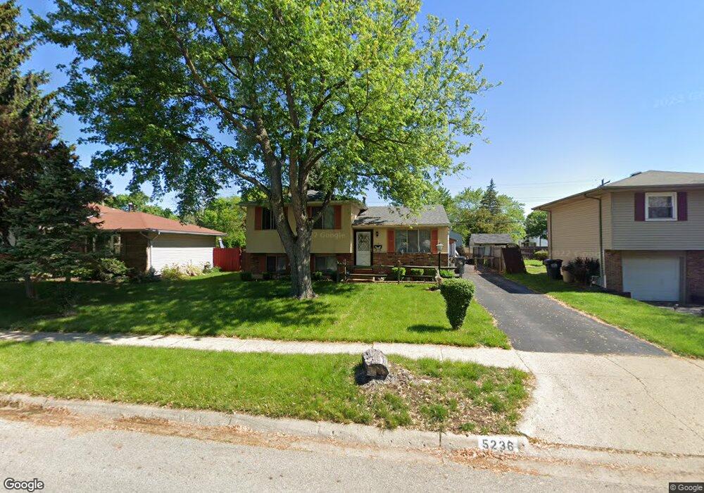
5236 Tuxworth Dr Columbus, OH 43232
East Columbus-White Ash NeighborhoodEstimated Value: $181,000 - $217,000
3
Beds
1
Bath
1,282
Sq Ft
$158/Sq Ft
Est. Value
About This Home
This home is located at 5236 Tuxworth Dr, Columbus, OH 43232 and is currently estimated at $202,255, approximately $157 per square foot. 5236 Tuxworth Dr is a home located in Franklin County with nearby schools including Groveport Madison High School, A+ Arts Academy, and Eastland Preparatory Academy.
Ownership History
Date
Name
Owned For
Owner Type
Purchase Details
Closed on
Sep 25, 1996
Sold by
Dearing Barbara E
Bought by
Peter A Welch
Current Estimated Value
Home Financials for this Owner
Home Financials are based on the most recent Mortgage that was taken out on this home.
Original Mortgage
$72,200
Outstanding Balance
$6,559
Interest Rate
7.97%
Mortgage Type
New Conventional
Estimated Equity
$195,696
Purchase Details
Closed on
Oct 1, 1991
Purchase Details
Closed on
Dec 1, 1983
Create a Home Valuation Report for This Property
The Home Valuation Report is an in-depth analysis detailing your home's value as well as a comparison with similar homes in the area
Home Values in the Area
Average Home Value in this Area
Purchase History
| Date | Buyer | Sale Price | Title Company |
|---|---|---|---|
| Peter A Welch | $76,000 | -- | |
| -- | $66,500 | -- | |
| -- | $50,100 | -- |
Source: Public Records
Mortgage History
| Date | Status | Borrower | Loan Amount |
|---|---|---|---|
| Open | Peter A Welch | $72,200 |
Source: Public Records
Tax History Compared to Growth
Tax History
| Year | Tax Paid | Tax Assessment Tax Assessment Total Assessment is a certain percentage of the fair market value that is determined by local assessors to be the total taxable value of land and additions on the property. | Land | Improvement |
|---|---|---|---|---|
| 2024 | $2,881 | $56,700 | $17,080 | $39,620 |
| 2023 | $2,767 | $56,700 | $17,080 | $39,620 |
| 2022 | $1,958 | $31,370 | $6,340 | $25,030 |
| 2021 | $2,002 | $31,370 | $6,340 | $25,030 |
| 2020 | $2,028 | $31,370 | $6,340 | $25,030 |
| 2019 | $1,984 | $27,550 | $5,530 | $22,020 |
| 2018 | $1,922 | $27,550 | $5,530 | $22,020 |
| 2017 | $1,959 | $27,550 | $5,530 | $22,020 |
| 2016 | $1,967 | $25,200 | $4,130 | $21,070 |
| 2015 | $1,906 | $25,200 | $4,130 | $21,070 |
| 2014 | $1,878 | $25,200 | $4,130 | $21,070 |
| 2013 | $914 | $28,000 | $4,585 | $23,415 |
Source: Public Records
Map
Nearby Homes
- 5125 Upton Rd N
- 2998 Osgood Rd E
- 2901 Renfro Rd
- 3000 Whitlow Rd
- 3246 Latonia Rd
- 2900 Ronda Rd
- 5373 Spire Ln
- 5152 Burdett Dr
- 3387 Retriever Rd
- 5401 Spire Ln
- 5397 Jack Russell Way
- 4847 Amber Crossing Dr
- 4784 Nieles Edge Dr
- 4783 Nieles Edge Dr
- 4906 Refugee Rd
- 5137 Holbrook Dr
- 5254 Sedalia Dr
- 5377 Bleaker Ave
- 5522 Newport Ct
- 5391 Newport Rd
- 5228 Tuxworth Dr
- 5244 Tuxworth Dr
- 5218 Tuxworth Dr
- 5252 Tuxworth Dr
- 5233 Tuxworth Dr
- 5264 Tuxworth Dr
- 5241 Tuxworth Dr
- 3060 Dunloe Rd
- 5225 Tuxworth Dr
- 5249 Tuxworth Dr
- 5217 Parkline Dr
- 3061 Fleet Rd
- 5213 Tuxworth Dr
- 5209 Parkline Dr
- 5276 Tuxworth Dr
- 5261 Tuxworth Dr
- 5201 Parkline Dr
- 5153 Tuxworth Dr
- 3088 Dunloe Rd
- 3060 Fleet Rd