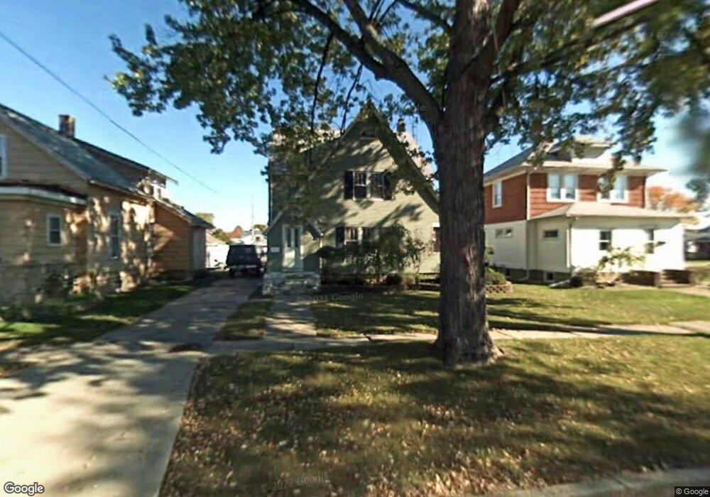
525 Adams St Port Clinton, OH 43452
Estimated Value: $192,000 - $264,000
4
Beds
2
Baths
1,696
Sq Ft
$132/Sq Ft
Est. Value
About This Home
This home is located at 525 Adams St, Port Clinton, OH 43452 and is currently estimated at $223,966, approximately $132 per square foot. 525 Adams St is a home located in Ottawa County with nearby schools including Bataan Memorial Primary School, Bataan Memorial Intermediate School, and Port Clinton Middle School.
Ownership History
Date
Name
Owned For
Owner Type
Purchase Details
Closed on
Aug 11, 2017
Sold by
Mcdavitt Earl K
Bought by
Market Nicole M
Current Estimated Value
Home Financials for this Owner
Home Financials are based on the most recent Mortgage that was taken out on this home.
Original Mortgage
$118,808
Outstanding Balance
$100,545
Interest Rate
4.5%
Mortgage Type
FHA
Estimated Equity
$123,421
Purchase Details
Closed on
Dec 2, 2005
Sold by
Zerman Darlene M and Mcdavitt Darlene M
Bought by
Mcdavitt Earl K
Home Financials for this Owner
Home Financials are based on the most recent Mortgage that was taken out on this home.
Original Mortgage
$108,335
Interest Rate
6.36%
Mortgage Type
New Conventional
Create a Home Valuation Report for This Property
The Home Valuation Report is an in-depth analysis detailing your home's value as well as a comparison with similar homes in the area
Home Values in the Area
Average Home Value in this Area
Purchase History
| Date | Buyer | Sale Price | Title Company |
|---|---|---|---|
| Market Nicole M | $121,000 | None Available | |
| Mcdavitt Earl K | -- | Mortgage Information Service |
Source: Public Records
Mortgage History
| Date | Status | Borrower | Loan Amount |
|---|---|---|---|
| Open | Market Nicole M | $118,808 | |
| Previous Owner | Mcdavitt Earl K | $108,335 |
Source: Public Records
Tax History Compared to Growth
Tax History
| Year | Tax Paid | Tax Assessment Tax Assessment Total Assessment is a certain percentage of the fair market value that is determined by local assessors to be the total taxable value of land and additions on the property. | Land | Improvement |
|---|---|---|---|---|
| 2024 | $1,836 | $51,685 | $9,989 | $41,696 |
| 2023 | $1,836 | $40,769 | $7,690 | $33,079 |
| 2022 | $1,621 | $40,768 | $7,689 | $33,079 |
| 2021 | $1,619 | $40,770 | $7,690 | $33,080 |
| 2020 | $1,328 | $34,940 | $5,920 | $29,020 |
| 2019 | $1,315 | $34,940 | $5,920 | $29,020 |
| 2018 | $1,312 | $34,940 | $5,920 | $29,020 |
| 2017 | $1,167 | $30,580 | $5,920 | $24,660 |
| 2016 | $1,170 | $30,580 | $5,920 | $24,660 |
| 2015 | $1,174 | $30,580 | $5,920 | $24,660 |
| 2014 | $592 | $30,580 | $5,920 | $24,660 |
| 2013 | $1,188 | $30,580 | $5,920 | $24,660 |
Source: Public Records
Map
Nearby Homes
- 321 E 7th St
- 516 Jefferson St
- 423 Fulton St
- 123 E 10th St
- 424 Monroe St
- 721 Monroe St
- 2621 N Peachtree Lane # Sublot 1
- 2453 N Peachtree Lane # Sublot 7
- 2481 N Peachtree Lane # Sublot 6
- 2565 N Peachtree Lane # Sublot 3
- 0 Mouse Island Unit 20252634
- 2369 N Peachtree Lane # Sublot 10
- 2397 N Peachtree Lane # Sublot 9
- 2509 N Peachtree Lane # Sublot 5
- 2537 N Peachtree Lane # Sublot 4
- 0 Mouse Island Unit 5139279
- 2425 N Peachtree Lane # Sublot 8
- 229 W 4th St
- 519 E 11th St
- 521 E 2nd St