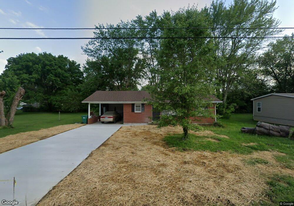
525 Maxie Ct New Haven, KY 40051
Estimated Value: $52,000 - $182,000
3
Beds
1
Bath
1,008
Sq Ft
$139/Sq Ft
Est. Value
About This Home
This home is located at 525 Maxie Ct, New Haven, KY 40051 and is currently estimated at $140,051, approximately $138 per square foot. 525 Maxie Ct is a home located in Nelson County with nearby schools including Nelson County High School and St Catherine Academy.
Ownership History
Date
Name
Owned For
Owner Type
Purchase Details
Closed on
Nov 17, 2020
Sold by
Mill City Mortgage Loan Trusts
Bought by
Satterly Donald and Satterly Stacy
Current Estimated Value
Home Financials for this Owner
Home Financials are based on the most recent Mortgage that was taken out on this home.
Original Mortgage
$15,000
Interest Rate
2.8%
Mortgage Type
Future Advance Clause Open End Mortgage
Purchase Details
Closed on
Feb 17, 2020
Sold by
Hall William Thomas and Hall William T
Bought by
Mill City Mortgage Loan Trust 2018 2
Create a Home Valuation Report for This Property
The Home Valuation Report is an in-depth analysis detailing your home's value as well as a comparison with similar homes in the area
Home Values in the Area
Average Home Value in this Area
Purchase History
| Date | Buyer | Sale Price | Title Company |
|---|---|---|---|
| Satterly Donald | $35,000 | None Available | |
| Mill City Mortgage Loan Trust 2018 2 | $35,000 | None Available |
Source: Public Records
Mortgage History
| Date | Status | Borrower | Loan Amount |
|---|---|---|---|
| Closed | Satterly Donald | $15,000 |
Source: Public Records
Tax History Compared to Growth
Tax History
| Year | Tax Paid | Tax Assessment Tax Assessment Total Assessment is a certain percentage of the fair market value that is determined by local assessors to be the total taxable value of land and additions on the property. | Land | Improvement |
|---|---|---|---|---|
| 2024 | $732 | $67,290 | $0 | $0 |
| 2023 | $732 | $67,290 | $0 | $0 |
| 2022 | $740 | $67,290 | $67,290 | $0 |
| 2021 | $750 | $67,290 | $67,290 | $0 |
| 2020 | $734 | $67,290 | $67,290 | $0 |
| 2019 | $769 | $67,290 | $67,290 | $0 |
| 2018 | $784 | $67,290 | $67,290 | $0 |
| 2017 | -- | $67,290 | $67,290 | $0 |
| 2016 | -- | $67,290 | $67,290 | $0 |
| 2015 | $670 | $67,290 | $67,290 | $0 |
| 2014 | $670 | $67,290 | $67,290 | $0 |
| 2012 | $670 | $67,290 | $67,290 | $0 |
Source: Public Records
Map
Nearby Homes
- 461 High St
- 331 Center St
- 264 A Saint Catherine St
- 0 New Haven Rd
- 1276 Lyons Station Rd
- 2234 New Hope Rd
- 4580 Cissal Hill Rd
- 10640 New Haven Rd
- 0000000000 Ice Town Rd
- 6250 New Hope Rd
- 2920 Nat Rogers Rd
- 750 Block Eddie Miles Rd
- 546 Joe Brown Rd
- 200 Nat Rogers Rd
- 6529 Nat Rogers Rd
- 2568 Holy Cross Rd
- 248 Maple Ct
- 272, 277 Hills Place
- 259,260,26 Sycamore Dr
- 202 Lakeview Dr