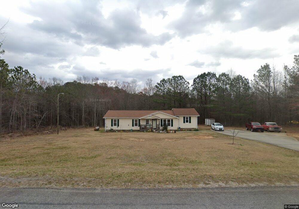
525 Pollard Rd Temple, GA 30179
Estimated Value: $261,766 - $360,000
3
Beds
2
Baths
1,560
Sq Ft
$203/Sq Ft
Est. Value
About This Home
This home is located at 525 Pollard Rd, Temple, GA 30179 and is currently estimated at $316,442, approximately $202 per square foot. 525 Pollard Rd is a home located in Haralson County with nearby schools including Haralson County High School.
Ownership History
Date
Name
Owned For
Owner Type
Purchase Details
Closed on
Dec 31, 2011
Sold by
Billings Ricky
Bought by
Merritt Gary
Current Estimated Value
Purchase Details
Closed on
Dec 27, 2011
Sold by
Billings Ricky
Bought by
Merritt Gary
Purchase Details
Closed on
Apr 2, 1996
Sold by
Billings
Bought by
Billings Tony and Billings Maxine
Create a Home Valuation Report for This Property
The Home Valuation Report is an in-depth analysis detailing your home's value as well as a comparison with similar homes in the area
Home Values in the Area
Average Home Value in this Area
Purchase History
| Date | Buyer | Sale Price | Title Company |
|---|---|---|---|
| Merritt Gary | -- | -- | |
| Merritt Gary | -- | -- | |
| Billings Tony | $1,500 | -- |
Source: Public Records
Tax History Compared to Growth
Tax History
| Year | Tax Paid | Tax Assessment Tax Assessment Total Assessment is a certain percentage of the fair market value that is determined by local assessors to be the total taxable value of land and additions on the property. | Land | Improvement |
|---|---|---|---|---|
| 2024 | $873 | $44,592 | $2,664 | $41,928 |
| 2023 | $1,232 | $47,934 | $2,214 | $45,720 |
| 2022 | $1,010 | $39,664 | $2,214 | $37,450 |
| 2021 | $992 | $37,502 | $1,965 | $35,537 |
| 2020 | $1,026 | $38,563 | $1,965 | $36,598 |
| 2019 | $1,036 | $37,557 | $1,965 | $35,592 |
| 2018 | $1,060 | $37,855 | $1,965 | $35,890 |
| 2017 | $971 | $31,855 | $1,965 | $29,890 |
| 2016 | $797 | $28,023 | $3,400 | $24,623 |
| 2015 | $790 | $27,751 | $3,400 | $24,352 |
| 2014 | $777 | $27,752 | $3,400 | $24,352 |
Source: Public Records
Map
Nearby Homes
- 395 Pollard Rd
- 242 Brookshire Dr
- 24 Mcclure Rd
- 212 Webster Lake Dr
- 248 Webster Lake Dr
- 426 Amy Blvd
- 362 Webster Lake Dr
- 128 Pollard Rd
- 0 Pollard Rd Unit 10533145
- 0 Pollard Rd Unit 10533156
- 0 Us Highway 78 Unit 10533174
- 0 Us Highway 78 Unit 10533179
- 90 Defnall Rd
- 115 Glen Helton Rd
- 1109 Liberty Church Rd
- 972 Seventh Court Ground Rd
- 136 Rainey Rd
- 116 Tallapoosa St
- 9385 U S 78
- 400 Sapling Ct
- 495 Pollard Rd
- 462 Pollard Rd
- 37 Rolling Rock Rd
- 485 Pollard Rd
- 493 Pollard Rd
- 24 Rolling Rock Rd
- 640 Pollard Rd
- 10 Rolling Rock Rd
- 121 Rolling Rock Rd
- 125 Rolling Rock Rd
- 0 Rolling Rock Rd Unit 7018450
- 0 Rolling Rock Rd Unit 8119719
- 0 Rolling Rock Rd
- 425 Pollard Rd
- 652 Pollard Rd
- 262 Mcclure Rd
- 104 Rolling Rock Rd
- 427 Pollard Rd
- 404 Pollard Rd
- 254 Mcclure Rd