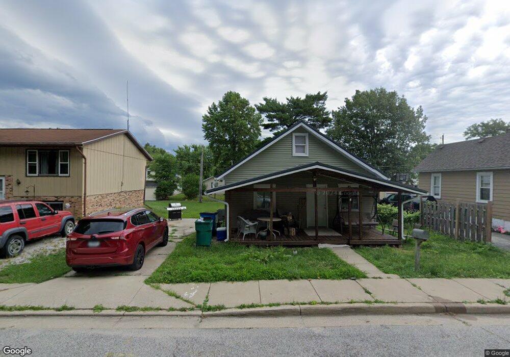
525 Porter St La Porte, IN 46350
Estimated Value: $105,000 - $211,000
--
Bed
1
Bath
713
Sq Ft
$204/Sq Ft
Est. Value
About This Home
This home is located at 525 Porter St, La Porte, IN 46350 and is currently estimated at $145,802, approximately $204 per square foot. 525 Porter St is a home located in LaPorte County with nearby schools including Riley Elementary School, La Porte High School, and Dunkerton High School.
Ownership History
Date
Name
Owned For
Owner Type
Purchase Details
Closed on
Apr 25, 2024
Sold by
Shamrockville Llc
Bought by
Mcbroom Amanda and Setina Thomas
Current Estimated Value
Purchase Details
Closed on
Jul 27, 2023
Sold by
West Michelle and Larosa Michelle
Bought by
Shamrockville Llc
Purchase Details
Closed on
Apr 30, 2010
Sold by
Larosa Stephen G
Bought by
West Michelle and Larosa Michelle
Purchase Details
Closed on
Sep 20, 2006
Sold by
West Michael L
Bought by
Larosa Stephen G and Larosa Michelle
Create a Home Valuation Report for This Property
The Home Valuation Report is an in-depth analysis detailing your home's value as well as a comparison with similar homes in the area
Home Values in the Area
Average Home Value in this Area
Purchase History
| Date | Buyer | Sale Price | Title Company |
|---|---|---|---|
| Mcbroom Amanda | -- | None Listed On Document | |
| Shamrockville Llc | -- | None Listed On Document | |
| Euler Michelle | -- | None Listed On Document | |
| West Michelle | -- | None Available | |
| Larosa Stephen G | $33,000 | None Available |
Source: Public Records
Mortgage History
| Date | Status | Borrower | Loan Amount |
|---|---|---|---|
| Closed | Larosa Stephen G | $0 |
Source: Public Records
Tax History Compared to Growth
Tax History
| Year | Tax Paid | Tax Assessment Tax Assessment Total Assessment is a certain percentage of the fair market value that is determined by local assessors to be the total taxable value of land and additions on the property. | Land | Improvement |
|---|---|---|---|---|
| 2024 | $599 | $62,100 | $16,700 | $45,400 |
| 2022 | $544 | $58,400 | $15,600 | $42,800 |
| 2021 | $523 | $55,200 | $15,600 | $39,600 |
| 2020 | $446 | $55,200 | $15,600 | $39,600 |
| 2019 | $492 | $48,200 | $12,000 | $36,200 |
| 2018 | $339 | $42,400 | $9,600 | $32,800 |
| 2017 | $324 | $42,200 | $9,600 | $32,600 |
| 2016 | $411 | $52,300 | $8,300 | $44,000 |
| 2014 | $336 | $48,900 | $8,300 | $40,600 |
Source: Public Records
Map
Nearby Homes
- 604 Weller Ave
- 245 Pine Lake Ave
- 720 Weller Ave
- 0 N Highway 35 Rd
- 412 Woodbine St
- 710 Central Ave
- 1424 Weller Ave
- 410 Closser Ave
- 0 N State Road 39 Unit 202541633
- 0 N State Road 39 Unit 202541606
- 0 N State Road 39 Unit 202544621
- 610 Home St
- 1522 Sallwasser Ave
- 1401 Jefferson Ave
- 1010 2nd St
- 809 Chicago St
- 0 N 400 W Unit NRA544762
- 3069 N Morning Glory Ave
- 3067 N Morning Glory Ave
- 0 W Lot 81 Concord Dr Unit NRA809376