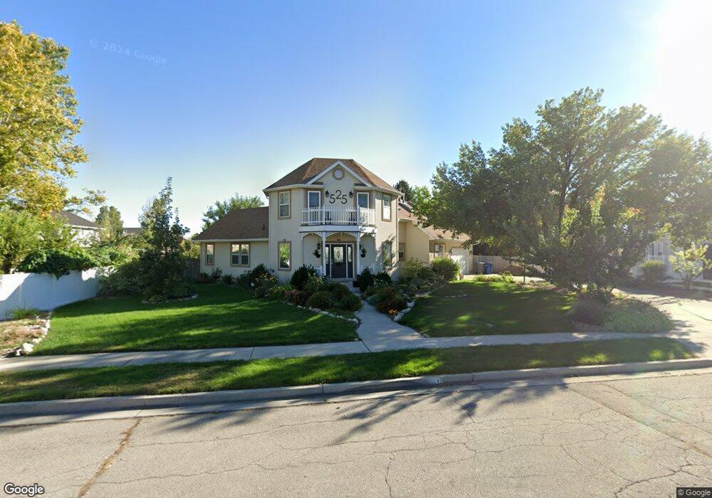
525 W 860 N American Fork, UT 84003
Estimated Value: $938,000 - $1,194,000
5
Beds
4
Baths
4,456
Sq Ft
$227/Sq Ft
Est. Value
About This Home
This home is located at 525 W 860 N, American Fork, UT 84003 and is currently estimated at $1,010,634, approximately $226 per square foot. 525 W 860 N is a home located in Utah County with nearby schools including Shelley Elementary School, American Fork Junior High School, and American Fork High School.
Ownership History
Date
Name
Owned For
Owner Type
Purchase Details
Closed on
Nov 10, 2022
Sold by
Hudson Annette
Bought by
Hudson Annette Meikle
Current Estimated Value
Purchase Details
Closed on
Aug 17, 2021
Sold by
Monte Hudson
Bought by
Hudson Annette
Purchase Details
Closed on
Feb 16, 2017
Sold by
Gladwin Bruce and Gladwin Michelle
Bought by
Hudson Monte and Hudson Annette
Home Financials for this Owner
Home Financials are based on the most recent Mortgage that was taken out on this home.
Original Mortgage
$308,000
Interest Rate
3.5%
Mortgage Type
Adjustable Rate Mortgage/ARM
Purchase Details
Closed on
Oct 1, 2007
Sold by
Mdf Estate Planning Services Inc
Bought by
Schroeder Steven
Purchase Details
Closed on
Feb 16, 2006
Sold by
Husebye Antonette E
Bought by
Gladwin Bruce and Gladwin Michelle
Home Financials for this Owner
Home Financials are based on the most recent Mortgage that was taken out on this home.
Original Mortgage
$184,900
Interest Rate
6.2%
Mortgage Type
Fannie Mae Freddie Mac
Purchase Details
Closed on
Oct 14, 2005
Sold by
Snave Development Llc
Bought by
Skadi Investment Group Llc
Home Financials for this Owner
Home Financials are based on the most recent Mortgage that was taken out on this home.
Original Mortgage
$400,482
Interest Rate
5.67%
Mortgage Type
Purchase Money Mortgage
Purchase Details
Closed on
Dec 13, 2004
Sold by
Mhm Enterprises Inc
Bought by
Forsetti Investment Group Llc
Purchase Details
Closed on
Feb 10, 2003
Sold by
Miner David E and Miner Tami P
Bought by
Husebye Antonette E
Home Financials for this Owner
Home Financials are based on the most recent Mortgage that was taken out on this home.
Original Mortgage
$264,400
Interest Rate
5.76%
Purchase Details
Closed on
Nov 12, 2002
Sold by
Miner David E and Miner Tamara P
Bought by
Miner David E and Miner Tami P
Purchase Details
Closed on
Oct 8, 1998
Sold by
Miner David E and Miner Tami P
Bought by
Miner David E and Miner Tami P
Home Financials for this Owner
Home Financials are based on the most recent Mortgage that was taken out on this home.
Original Mortgage
$131,500
Interest Rate
6.79%
Purchase Details
Closed on
Aug 1, 1996
Sold by
Miner David E and Miner Tamara P
Bought by
Miner David E and Miner Tami P
Create a Home Valuation Report for This Property
The Home Valuation Report is an in-depth analysis detailing your home's value as well as a comparison with similar homes in the area
Home Values in the Area
Average Home Value in this Area
Purchase History
| Date | Buyer | Sale Price | Title Company |
|---|---|---|---|
| Hudson Annette Meikle | -- | -- | |
| Hudson Annette | -- | None Listed On Document | |
| Hudson Monte | -- | First American Title | |
| Schroeder Steven | -- | Utah First Title Insurance | |
| Gladwin Bruce | -- | Utah First Title Insurance | |
| Skadi Investment Group Llc | -- | Utah First Title Insurance | |
| Forsetti Investment Group Llc | -- | Utah First Title Insurance | |
| Husebye Antonette E | -- | Empire Land Title Company | |
| Miner David E | -- | Old Republic Title Of Utah | |
| Miner David E | -- | Old Republic Title | |
| Miner David E | -- | -- | |
| Miner David E | -- | -- | |
| Miner David E | -- | -- |
Source: Public Records
Mortgage History
| Date | Status | Borrower | Loan Amount |
|---|---|---|---|
| Previous Owner | Hudson Monte | $308,000 | |
| Previous Owner | Gladwin Bruce | $184,900 | |
| Previous Owner | Skadi Investment Group Llc | $400,482 | |
| Previous Owner | Husebye Antonette E | $264,400 | |
| Previous Owner | Miner David E | $131,500 |
Source: Public Records
Tax History Compared to Growth
Tax History
| Year | Tax Paid | Tax Assessment Tax Assessment Total Assessment is a certain percentage of the fair market value that is determined by local assessors to be the total taxable value of land and additions on the property. | Land | Improvement |
|---|---|---|---|---|
| 2025 | $3,483 | $450,560 | $263,600 | $555,600 |
| 2024 | $3,168 | $386,980 | $0 | $0 |
| 2023 | $3,168 | $373,175 | $0 | $0 |
| 2022 | $3,025 | $351,670 | $0 | $0 |
| 2021 | $2,593 | $470,800 | $189,100 | $281,700 |
| 2020 | $2,426 | $427,200 | $168,800 | $258,400 |
| 2019 | $2,276 | $414,600 | $156,200 | $258,400 |
| 2018 | $2,332 | $406,100 | $147,700 | $258,400 |
| 2017 | $2,253 | $231,330 | $0 | $0 |
| 2016 | $2,606 | $227,535 | $0 | $0 |
| 2015 | $2,734 | $226,600 | $0 | $0 |
| 2014 | $2,441 | $199,540 | $0 | $0 |
Source: Public Records
Map
Nearby Homes
- 602 W 860 N
- 914 N 400 W Unit A
- 987 N 410 W
- 3889 W 950 Cir N Unit 366
- 471 W 1040 N
- 641 N 420 W
- 984 N 300 W
- 425 W 1120 N
- 344 W 1080 N
- 962 N 780 St W Unit 508
- 974 N 780 St W Unit 509
- 916 N 780 St W Unit 501
- 822 W 800 St N Unit LOT319
- 822 N 860 W Unit 317
- 796 N 200 W
- 782 N 200 W
- 540 N 300 W
- 3935 W 1000 N Unit 438
- 3983 W 1000 N Unit 442
- 4007 W 1000 N