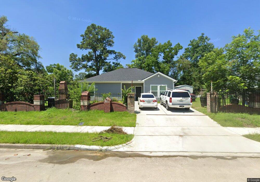
5262 Cosby St Houston, TX 77021
OST-South Union NeighborhoodEstimated Value: $223,000 - $252,951
4
Beds
2
Baths
1,464
Sq Ft
$166/Sq Ft
Est. Value
About This Home
This home is located at 5262 Cosby St, Houston, TX 77021 and is currently estimated at $242,738, approximately $165 per square foot. 5262 Cosby St is a home located in Harris County with nearby schools including Hartsfield Elementary Animal and Environmental Sciences Magnet, Cullen Middle School, and Yates High School.
Ownership History
Date
Name
Owned For
Owner Type
Purchase Details
Closed on
Apr 20, 2006
Sold by
Chenevert Partners Llc
Bought by
Jwr Ho Lp
Current Estimated Value
Home Financials for this Owner
Home Financials are based on the most recent Mortgage that was taken out on this home.
Original Mortgage
$240,000
Interest Rate
6.33%
Mortgage Type
Purchase Money Mortgage
Purchase Details
Closed on
Feb 27, 2006
Sold by
Wizig Scott
Bought by
Rodriguez Israel and Rodriguez Maria
Home Financials for this Owner
Home Financials are based on the most recent Mortgage that was taken out on this home.
Original Mortgage
$240,000
Interest Rate
6.33%
Mortgage Type
Purchase Money Mortgage
Create a Home Valuation Report for This Property
The Home Valuation Report is an in-depth analysis detailing your home's value as well as a comparison with similar homes in the area
Home Values in the Area
Average Home Value in this Area
Purchase History
| Date | Buyer | Sale Price | Title Company |
|---|---|---|---|
| Jwr Ho Lp | -- | None Available | |
| Rodriguez Israel | -- | None Available |
Source: Public Records
Mortgage History
| Date | Status | Borrower | Loan Amount |
|---|---|---|---|
| Closed | Jwr Ho Lp | $240,000 | |
| Previous Owner | Rodriguez Israel | $9,973 |
Source: Public Records
Tax History Compared to Growth
Tax History
| Year | Tax Paid | Tax Assessment Tax Assessment Total Assessment is a certain percentage of the fair market value that is determined by local assessors to be the total taxable value of land and additions on the property. | Land | Improvement |
|---|---|---|---|---|
| 2025 | $2,044 | $219,265 | $79,938 | $139,327 |
| 2024 | $2,044 | $253,606 | $79,938 | $173,668 |
| 2023 | $2,044 | $170,868 | $79,938 | $90,930 |
| 2022 | $2,022 | $153,645 | $73,277 | $80,368 |
| 2021 | $3,089 | $132,535 | $53,292 | $79,243 |
| 2020 | $1,829 | $107,123 | $33,308 | $73,815 |
| 2019 | $1,735 | $75,290 | $28,311 | $46,979 |
| 2018 | $911 | $59,606 | $19,985 | $39,621 |
| 2017 | $1,576 | $59,606 | $19,985 | $39,621 |
| 2016 | $1,576 | $59,606 | $19,985 | $39,621 |
| 2015 | $1,248 | $58,041 | $19,985 | $38,056 |
| 2014 | $1,248 | $48,550 | $16,654 | $31,896 |
Source: Public Records
Map
Nearby Homes
- 5244 Enyart St
- 5259 Perry St
- 5251 Perry St
- 5210 Enyart St
- 5219 Cosby St
- 5322 Dewberry St
- 6527 Beekman Rd
- 5218 Kelso St
- 5224 Dewberry St
- 5251 Dewberry St
- 5338 Keystone St
- 5601 Malmedy Rd
- 5941 South Loop E Unit 104
- 5215 Kingsbury St
- 6031 Beekman Rd
- 5111 Cosby St
- 4611 Dewberry St
- 5107 Gren St
- 5023 Cosby St
- 5022 Balkin St
- 6326 Beekman Rd
- 5258 Cosby St
- 5267 Cosby St
- 5251 Enyart St
- 5254 Cosby St
- 5247 Enyart St
- 5263 Cosby St
- 6323 Beekman Rd
- 6319 Beekman Rd
- 6327 Beekman Rd
- 5259 Cosby St
- 6308 Beekman Rd
- 6315 Beekman Rd
- 6331 Beekman Rd
- 5243 Enyart St
- 6311 Beekman Rd
- 5255 Cosby St
- 6335 Beekman Rd
- 5246 Cosby St
- 5278 Perry St