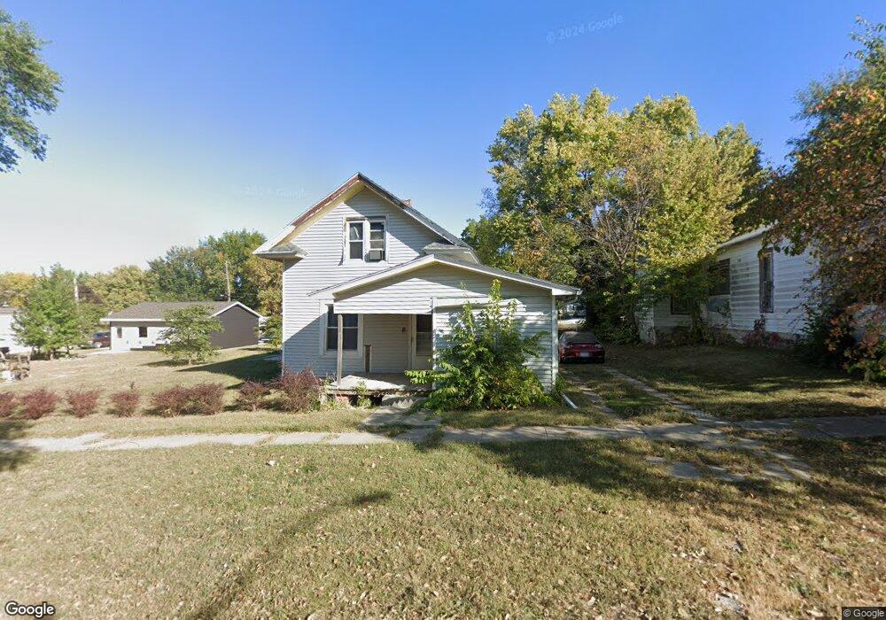
527 4th St Humboldt, NE 68376
Estimated Value: $68,585 - $165,000
3
Beds
1
Bath
1,136
Sq Ft
$97/Sq Ft
Est. Value
About This Home
This home is located at 527 4th St, Humboldt, NE 68376 and is currently estimated at $109,646, approximately $96 per square foot. 527 4th St is a home located in Richardson County with nearby schools including HTRS Elementary School, HTRS Middle School, and HTRS High School.
Ownership History
Date
Name
Owned For
Owner Type
Purchase Details
Closed on
Feb 22, 2005
Sold by
Skillett Dennis J and Skillett Cherryl L
Bought by
Richey Timothy and Richey Elecia
Current Estimated Value
Purchase Details
Closed on
Jul 21, 2004
Sold by
Wilson Jeromy Wayne
Bought by
Skillet Dennis
Purchase Details
Closed on
Jan 30, 2004
Sold by
Luallin Robert D
Bought by
Wilson Jeromy Wayne
Purchase Details
Closed on
Nov 12, 2003
Sold by
Mcclintock Raymond
Bought by
Luallin Robert D
Create a Home Valuation Report for This Property
The Home Valuation Report is an in-depth analysis detailing your home's value as well as a comparison with similar homes in the area
Home Values in the Area
Average Home Value in this Area
Purchase History
| Date | Buyer | Sale Price | Title Company |
|---|---|---|---|
| Richey Timothy | -- | -- | |
| Richey Timothy | -- | -- | |
| Skillet Dennis | -- | -- | |
| Wilson Jeromy Wayne | -- | -- | |
| Luallin Robert D | $8,000 | -- |
Source: Public Records
Tax History Compared to Growth
Tax History
| Year | Tax Paid | Tax Assessment Tax Assessment Total Assessment is a certain percentage of the fair market value that is determined by local assessors to be the total taxable value of land and additions on the property. | Land | Improvement |
|---|---|---|---|---|
| 2025 | $262 | $21,084 | $2,829 | $18,255 |
| 2024 | $262 | $20,569 | $2,829 | $17,740 |
| 2023 | $345 | $21,800 | $2,829 | $18,971 |
| 2022 | $269 | $14,282 | $1,002 | $13,280 |
| 2021 | $300 | $16,569 | $1,002 | $15,567 |
| 2020 | $296 | $15,828 | $1,002 | $14,826 |
| 2019 | $279 | $15,396 | $1,002 | $14,394 |
| 2018 | $276 | $14,330 | $1,002 | $13,328 |
| 2017 | $278 | $14,330 | $1,002 | $13,328 |
| 2016 | $296 | $14,330 | $1,002 | $13,328 |
| 2015 | $304 | $14,330 | $1,002 | $13,328 |
| 2014 | $153 | $7,072 | $1,002 | $6,070 |
Source: Public Records
Map
Nearby Homes
- 63824 711 Rd
- 63887 711 Rd
- 1108 Grand St
- TBD 708 Rd
- Tbd 708 Rd
- 64425 715 Trail
- 1346 G St
- 1041 5th St
- 547 I St
- 742 G St
- 603 9th St
- 70774 Nebraska 65
- 406 Elm St
- 350 Elk St
- 106 Center St
- 120 Center St
- Westgate Third Addition Unit Lot 19
- Westgate Third Addition Unit Lot 38
- Westgate Third Addition Unit Lot 29
- Westgate Third Addition Unit Lot 33