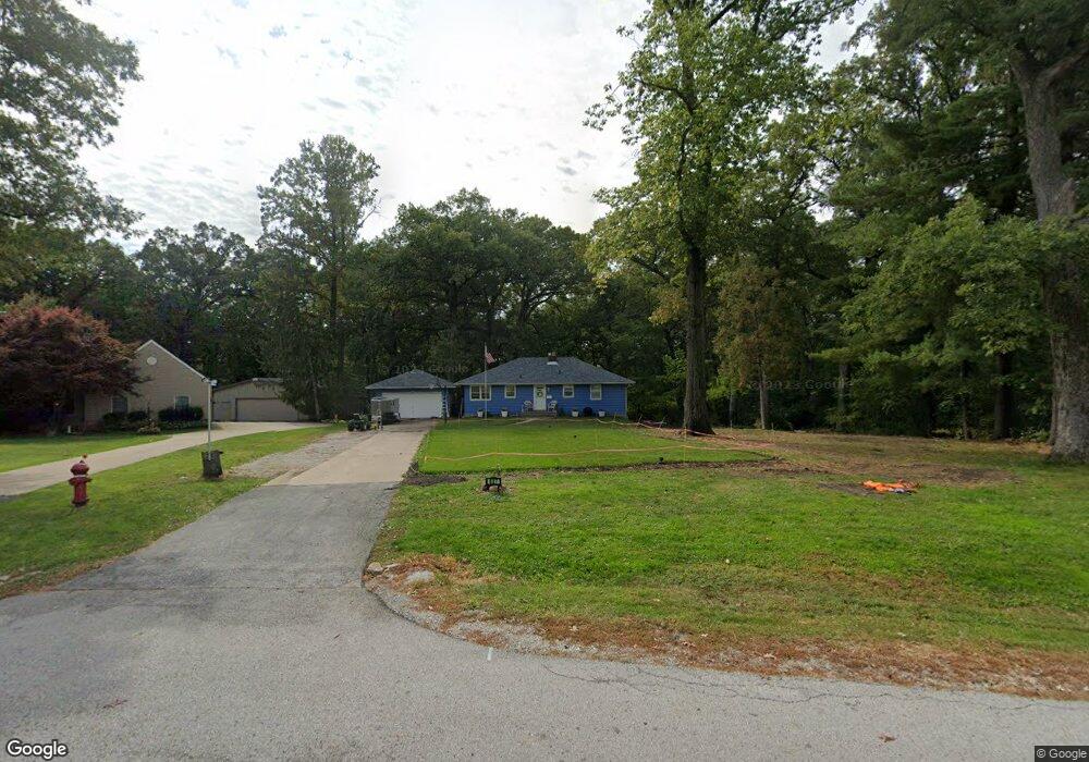
527 Forest Rd East Moline, IL 61244
Estimated Value: $153,527 - $211,000
--
Bed
--
Bath
1,232
Sq Ft
$145/Sq Ft
Est. Value
About This Home
This home is located at 527 Forest Rd, East Moline, IL 61244 and is currently estimated at $178,382, approximately $144 per square foot. 527 Forest Rd is a home located in Rock Island County with nearby schools including Wells Elementary School, Glenview Middle School, and United Township High School.
Ownership History
Date
Name
Owned For
Owner Type
Purchase Details
Closed on
May 16, 2022
Sold by
Norman William P
Bought by
William P Norman Revocable Living Trust and Norman
Current Estimated Value
Purchase Details
Closed on
Jun 26, 2018
Sold by
Norman William P
Bought by
Gillis Ronald G and Gillis Marnna R
Purchase Details
Closed on
Jul 19, 2017
Sold by
Norman George D
Bought by
Norman William P and Norman Ruth E
Purchase Details
Closed on
Jul 13, 2017
Sold by
Norman George D
Bought by
Norman William P and Norman Ruth E
Create a Home Valuation Report for This Property
The Home Valuation Report is an in-depth analysis detailing your home's value as well as a comparison with similar homes in the area
Home Values in the Area
Average Home Value in this Area
Purchase History
| Date | Buyer | Sale Price | Title Company |
|---|---|---|---|
| William P Norman Revocable Living Trust | -- | None Listed On Document | |
| Gillis Ronald G | -- | Lee & Lee Attorneys Pc | |
| Norman William P | $85,000 | Lee Graham J | |
| Norman William P | $85,000 | -- |
Source: Public Records
Tax History Compared to Growth
Tax History
| Year | Tax Paid | Tax Assessment Tax Assessment Total Assessment is a certain percentage of the fair market value that is determined by local assessors to be the total taxable value of land and additions on the property. | Land | Improvement |
|---|---|---|---|---|
| 2024 | $5,376 | $59,527 | $16,812 | $42,715 |
| 2023 | $5,376 | $54,813 | $15,481 | $39,332 |
| 2022 | $4,873 | $52,604 | $14,857 | $37,747 |
| 2021 | $4,764 | $50,291 | $14,204 | $36,087 |
| 2020 | $4,716 | $49,451 | $13,967 | $35,484 |
| 2019 | $4,936 | $48,672 | $13,747 | $34,925 |
| 2018 | $4,936 | $45,440 | $12,834 | $32,606 |
| 2017 | $1,004 | $44,725 | $12,632 | $32,093 |
| 2016 | $999 | $43,338 | $12,240 | $31,098 |
| 2015 | $992 | $42,355 | $11,962 | $30,393 |
| 2014 | -- | $42,779 | $12,082 | $30,697 |
| 2013 | -- | $42,779 | $12,082 | $30,697 |
Source: Public Records
Map
Nearby Homes
- 493 44th Avenue Ct
- 4303 7th St
- 4212 3rd Street A
- 602 41st Ave
- 4718 5th St
- 721 51st Ave
- 712 51st Ave
- 1000 48th Ave
- 4016 1st St
- 4521 11th Street Ct
- 4418 11th St
- 3427 3rd Street C
- 3432 3rd Street A
- 3403 4th St
- 385 34th Ave
- 1155 46th Ave
- 563 33rd Ave
- 1207 47th Avenue Ct
- 3401 56th Street Place Unit 2
- 634 32nd Ave