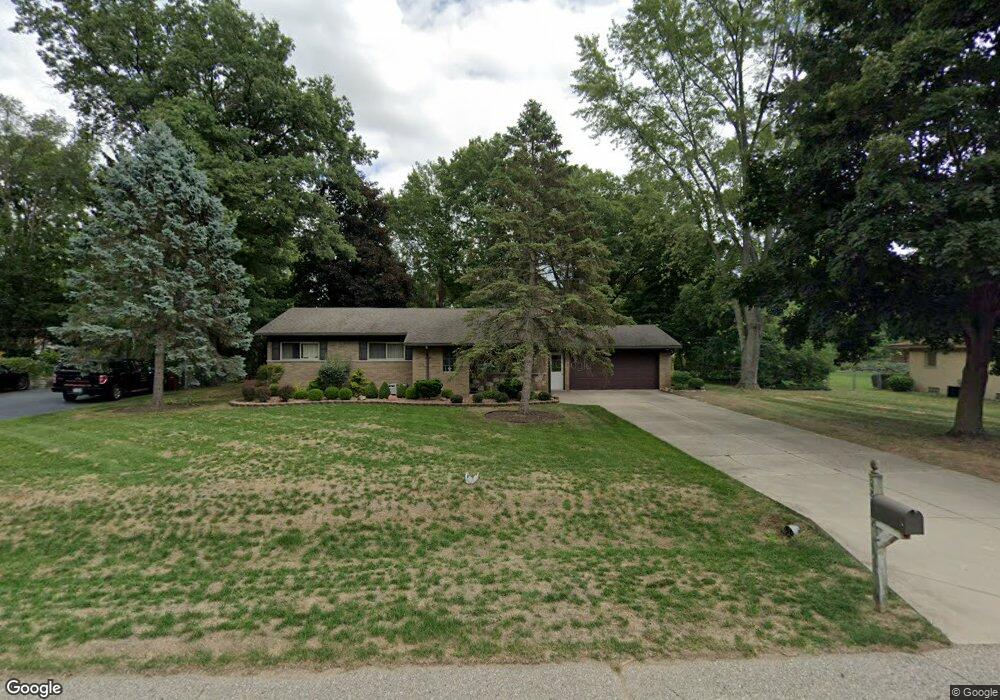
52752 Brookfield Ct Shelby Township, MI 48316
Estimated Value: $309,000 - $340,000
3
Beds
2
Baths
1,218
Sq Ft
$267/Sq Ft
Est. Value
About This Home
This home is located at 52752 Brookfield Ct, Shelby Township, MI 48316 and is currently estimated at $324,879, approximately $266 per square foot. 52752 Brookfield Ct is a home with nearby schools including Switzer Elementary School, Malow Junior High School, and Eisenhower High School.
Ownership History
Date
Name
Owned For
Owner Type
Purchase Details
Closed on
Oct 18, 2024
Sold by
Lindenthal Drew C
Bought by
Lindenthal Chase M
Current Estimated Value
Purchase Details
Closed on
Feb 5, 2024
Sold by
Lindenthal James M
Bought by
Lindenthal Drew C and Lindenthal Chase M
Purchase Details
Closed on
Jan 11, 2024
Sold by
Michael A Tallman Living Trust
Bought by
Lindenthal James M
Purchase Details
Closed on
Aug 17, 2018
Sold by
Tallman Michael A
Bought by
Tallman Michael A
Purchase Details
Closed on
Apr 11, 2017
Sold by
Tallman Michael A and Lindenthal James M
Bought by
Tallman Michael A
Create a Home Valuation Report for This Property
The Home Valuation Report is an in-depth analysis detailing your home's value as well as a comparison with similar homes in the area
Home Values in the Area
Average Home Value in this Area
Purchase History
| Date | Buyer | Sale Price | Title Company |
|---|---|---|---|
| Lindenthal Chase M | -- | None Listed On Document | |
| Lindenthal Chase M | -- | None Listed On Document | |
| Lindenthal Drew C | -- | None Listed On Document | |
| Lindenthal James M | -- | None Listed On Document | |
| Lindenthal James M | -- | None Listed On Document | |
| Tallman Michael A | -- | None Available | |
| Tallman Michael A | -- | None Available |
Source: Public Records
Tax History Compared to Growth
Tax History
| Year | Tax Paid | Tax Assessment Tax Assessment Total Assessment is a certain percentage of the fair market value that is determined by local assessors to be the total taxable value of land and additions on the property. | Land | Improvement |
|---|---|---|---|---|
| 2025 | $2,528 | $148,800 | $0 | $0 |
| 2024 | $1,496 | $137,100 | $0 | $0 |
| 2023 | $1,417 | $124,500 | $0 | $0 |
| 2022 | $2,286 | $112,700 | $0 | $0 |
| 2021 | $2,223 | $104,600 | $0 | $0 |
| 2020 | $1,305 | $94,200 | $0 | $0 |
| 2019 | $2,036 | $89,100 | $0 | $0 |
| 2018 | $1,996 | $89,500 | $0 | $0 |
| 2017 | $1,975 | $82,450 | $30,350 | $52,100 |
| 2016 | $1,961 | $82,450 | $0 | $0 |
| 2015 | $1,933 | $74,100 | $0 | $0 |
| 2012 | -- | $0 | $0 | $0 |
Source: Public Records
Map
Nearby Homes
- 52461 Pappy Ln
- 53162 Briar Dr
- 3515 Forster Ln Unit Lot 20
- 53588 Bruce Hill Dr
- 52527 Belle Vernon
- 3328 Forster Ln
- 53645 Lambeth Ct
- 53766 Tidal Ln
- 51677 Forster Ln Unit Lot 6
- 3252 Forster Ln
- 3191 Forster Ln Unit Lot 11
- 51605 Forster Ln Unit Lot 3
- 51581 Forster Ln Unit Lot 2
- 51557 Forster Ln Unit Lot 1
- 54060 Birchfield Dr W
- 51341 Neumaier Dr
- 54125 Carrington Dr Unit Lot 126
- 54169 Carrington Dr Unit Lot 125
- 54237 Trieste Ct
- 53266 Garland Dr
- 52778 Brookfield Ct
- 52726 Brookfield Ct
- 52745 Brenton
- 52711 Brenton
- 52674 Brookfield Ct
- 52779 Brookfield Ct
- 52824 Brookfield Ct
- 52753 Brookfield Ct
- 52675 Brenton
- 52781 Brenton
- 52727 Brookfield Ct
- 52825 Brenton
- 52656 Brookfield Ct
- 52823 Brookfield Ct
- 52653 Brenton
- 52675 Brookfield Ct
- 52848 Brookfield Ct
- 52861 Brenton
- 52847 Brookfield Ct
- 52752 Brenton