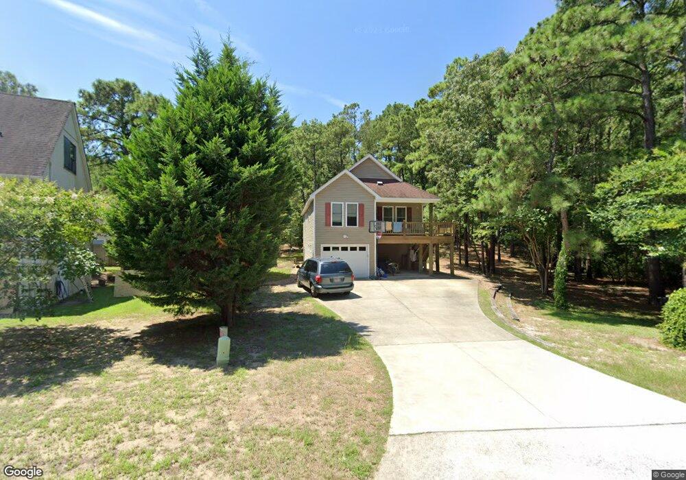
528 Burns Dr Kill Devil Hills, NC 27948
Estimated Value: $552,972 - $637,000
4
Beds
3
Baths
1,904
Sq Ft
$310/Sq Ft
Est. Value
About This Home
This home is located at 528 Burns Dr, Kill Devil Hills, NC 27948 and is currently estimated at $590,243, approximately $310 per square foot. 528 Burns Dr is a home located in Dare County with nearby schools including Nags Head Elementary School, Manteo Middle School, and Manteo High School.
Ownership History
Date
Name
Owned For
Owner Type
Purchase Details
Closed on
Aug 19, 2007
Sold by
Donaldson Graydon
Bought by
Jones Judy Donaldson
Current Estimated Value
Home Financials for this Owner
Home Financials are based on the most recent Mortgage that was taken out on this home.
Original Mortgage
$240,000
Outstanding Balance
$151,878
Interest Rate
6.65%
Mortgage Type
New Conventional
Estimated Equity
$438,365
Purchase Details
Closed on
Aug 6, 2007
Sold by
Williams Don Stephen and Williams Cynthia
Bought by
Voight John D and Voight Cobly L
Home Financials for this Owner
Home Financials are based on the most recent Mortgage that was taken out on this home.
Original Mortgage
$240,000
Outstanding Balance
$151,878
Interest Rate
6.65%
Mortgage Type
New Conventional
Estimated Equity
$438,365
Create a Home Valuation Report for This Property
The Home Valuation Report is an in-depth analysis detailing your home's value as well as a comparison with similar homes in the area
Home Values in the Area
Average Home Value in this Area
Purchase History
| Date | Buyer | Sale Price | Title Company |
|---|---|---|---|
| Jones Judy Donaldson | -- | None Available | |
| Voight John D | $300,000 | None Available |
Source: Public Records
Mortgage History
| Date | Status | Borrower | Loan Amount |
|---|---|---|---|
| Open | Jones Judy Donaldson | $240,000 | |
| Closed | Voight John D | $240,000 |
Source: Public Records
Tax History
| Year | Tax Paid | Tax Assessment Tax Assessment Total Assessment is a certain percentage of the fair market value that is determined by local assessors to be the total taxable value of land and additions on the property. | Land | Improvement |
|---|---|---|---|---|
| 2025 | $2,757 | $507,500 | $158,600 | $348,900 |
| 2024 | $2,311 | $305,900 | $88,100 | $217,800 |
| 2023 | $2,311 | $305,900 | $88,100 | $217,800 |
| 2022 | $2,204 | $305,900 | $88,100 | $217,800 |
| 2021 | $2,204 | $305,900 | $88,100 | $217,800 |
| 2020 | $2,204 | $305,900 | $88,100 | $217,800 |
| 2019 | $2,065 | $237,300 | $61,100 | $176,200 |
| 2018 | $2,019 | $237,300 | $61,100 | $176,200 |
| 2017 | $2,019 | $237,300 | $61,100 | $176,200 |
| 2016 | $1,924 | $237,300 | $61,100 | $176,200 |
| 2014 | $1,853 | $237,300 | $61,100 | $176,200 |
Source: Public Records
Map
Nearby Homes
- 311 Gunas Dr Unit 17
- 311 Gunas Dr
- 1308 Theodore St Unit 5
- 1208 Swan St Unit 4
- 1208 Swan St Unit 2
- 1208 Swan St Unit 5
- 1208 Swan St Unit 1
- 1208 -2 Swan St Unit 2
- 1208 -1 Swan St Unit 1
- 209 E Lake Dr Unit Lot18
- 0 10th Ave Unit Lot 2R 130569
- 203 W Carolinian Cir Unit Lot 8A
- 0 W Martin St
- 205 W Atlantic St Unit Lot 3
- 111 Carolyn Dr Unit E
- 2009 Wrightsville Blvd Unit 1-B
- 2009 Wrightsville Blvd Unit 4-B
- 2010 S Virginia Dare Trail Unit 104
- 209 E Fresh Pond Dr Unit Lot 10
- 1511 Wrightsville Blvd Unit Lot 64
- 600 W Ocean Acres Dr
- 602 W Ocean Acres Dr
- 513 Burns Dr Unit 47
- 513 Burns Dr
- 603 W Ocean Acres Dr
- 524 Burns Dr
- 604 W Ocean Acres Dr
- 526 W Ocean Acres Dr
- 601 W Ocean Acres Dr Unit 4
- 601 W Ocean Acres Dr Unit D
- 601 W Ocean Acres Dr Unit 3
- 601 W Ocean Acres Dr
- 601 W Ocean Acres Dr Unit 4D
- 511 Burns Dr
- 501 Burns Dr
- 533 Copley Dr
- 510 Burns Dr Unit 8
- 510 Burns Dr
- 518 Burns Dr
- 531 Copley Dr
Your Personal Tour Guide
Ask me questions while you tour the home.