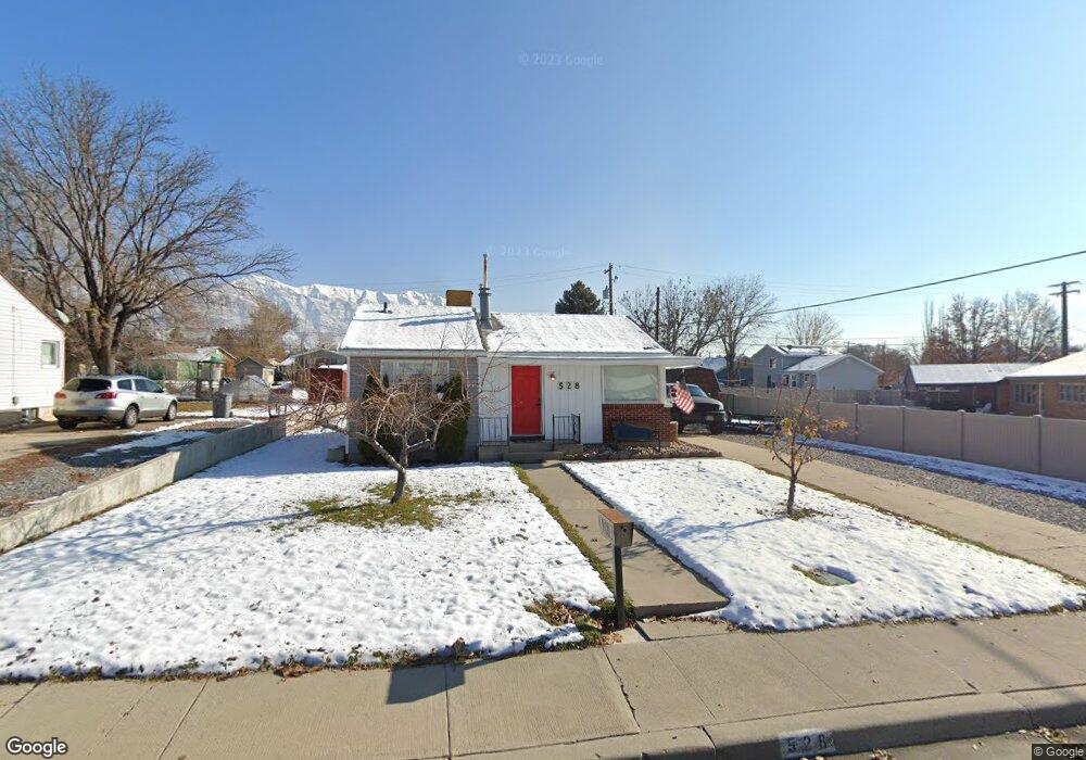
528 N 350 W American Fork, UT 84003
Estimated Value: $345,000 - $421,000
2
Beds
1
Bath
780
Sq Ft
$489/Sq Ft
Est. Value
About This Home
This home is located at 528 N 350 W, American Fork, UT 84003 and is currently estimated at $381,191, approximately $488 per square foot. 528 N 350 W is a home located in Utah County with nearby schools including Shelley Elementary School, American Fork Junior High School, and American Fork High School.
Ownership History
Date
Name
Owned For
Owner Type
Purchase Details
Closed on
Jan 28, 2014
Sold by
Convina Llc
Bought by
Moorman Derek
Current Estimated Value
Home Financials for this Owner
Home Financials are based on the most recent Mortgage that was taken out on this home.
Original Mortgage
$122,550
Outstanding Balance
$93,144
Interest Rate
4.49%
Mortgage Type
New Conventional
Estimated Equity
$288,047
Purchase Details
Closed on
Aug 7, 2013
Sold by
Morrill Margaret Ann
Bought by
Convina Llc and Zeek Properties Llc
Create a Home Valuation Report for This Property
The Home Valuation Report is an in-depth analysis detailing your home's value as well as a comparison with similar homes in the area
Home Values in the Area
Average Home Value in this Area
Purchase History
| Date | Buyer | Sale Price | Title Company |
|---|---|---|---|
| Moorman Derek | -- | First American Title Co Llc | |
| Convina Llc | -- | Legendstitle Llc |
Source: Public Records
Mortgage History
| Date | Status | Borrower | Loan Amount |
|---|---|---|---|
| Open | Moorman Derek | $122,550 |
Source: Public Records
Tax History Compared to Growth
Tax History
| Year | Tax Paid | Tax Assessment Tax Assessment Total Assessment is a certain percentage of the fair market value that is determined by local assessors to be the total taxable value of land and additions on the property. | Land | Improvement |
|---|---|---|---|---|
| 2025 | $1,524 | $183,920 | $189,500 | $144,900 |
| 2024 | $1,524 | $169,290 | $0 | $0 |
| 2023 | $1,402 | $165,165 | $0 | $0 |
| 2022 | $1,471 | $170,995 | $0 | $0 |
| 2021 | $1,248 | $226,600 | $136,000 | $90,600 |
| 2020 | $1,161 | $204,500 | $121,400 | $83,100 |
| 2019 | $1,027 | $187,000 | $104,100 | $82,900 |
| 2018 | $952 | $165,800 | $93,700 | $72,100 |
| 2017 | $895 | $84,095 | $0 | $0 |
| 2016 | $802 | $70,015 | $0 | $0 |
| 2015 | $845 | $70,015 | $0 | $0 |
| 2014 | $834 | $68,145 | $0 | $0 |
Source: Public Records
Map
Nearby Homes
- 540 N 300 W
- 641 N 420 W
- 356 N 480 W
- 621 N 100 W
- 370 W Pacific Dr Unit 1
- 365 N 100 W
- 782 N 200 W
- 796 N 200 W
- 399 W Pacific Dr
- 914 N 400 W Unit A
- 3889 W 950 Cir N Unit 366
- 374 N Center St
- 602 W 860 N
- 984 N 300 W
- 120 N 350 W Unit 127
- 120 N 350 W Unit 133
- 120 N 350 W Unit 130
- 987 N 410 W
- 962 N 780 St W Unit 508
- 974 N 780 St W Unit 509