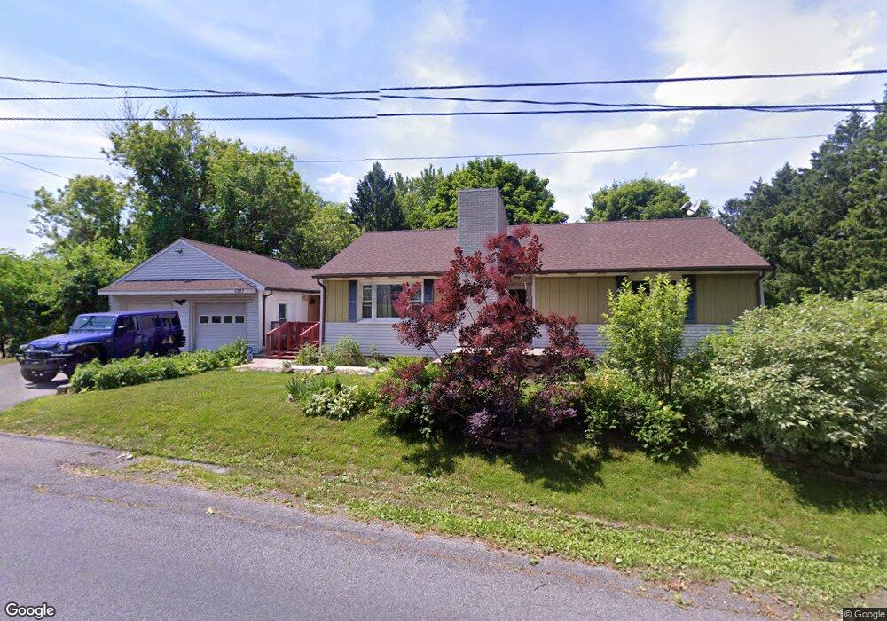
5283 Mill Rd Emmaus, PA 18049
Lower Macungie Township East NeighborhoodEstimated Value: $330,021 - $395,000
2
Beds
1
Bath
1,312
Sq Ft
$274/Sq Ft
Est. Value
About This Home
This home is located at 5283 Mill Rd, Emmaus, PA 18049 and is currently estimated at $359,755, approximately $274 per square foot. 5283 Mill Rd is a home located in Lehigh County with nearby schools including Macungie Elementary School, Eyer Middle School, and Emmaus High School.
Ownership History
Date
Name
Owned For
Owner Type
Purchase Details
Closed on
Apr 29, 2008
Sold by
Reiss Florence E
Bought by
Feiertag Mark J
Current Estimated Value
Home Financials for this Owner
Home Financials are based on the most recent Mortgage that was taken out on this home.
Original Mortgage
$188,000
Outstanding Balance
$119,246
Interest Rate
5.91%
Mortgage Type
Purchase Money Mortgage
Estimated Equity
$240,509
Purchase Details
Closed on
Apr 23, 1954
Bought by
Mohr Lawrence D and Mohr Pauline
Create a Home Valuation Report for This Property
The Home Valuation Report is an in-depth analysis detailing your home's value as well as a comparison with similar homes in the area
Home Values in the Area
Average Home Value in this Area
Purchase History
| Date | Buyer | Sale Price | Title Company |
|---|---|---|---|
| Feiertag Mark J | $11,800 | -- | |
| Mohr Lawrence D | $500 | -- |
Source: Public Records
Mortgage History
| Date | Status | Borrower | Loan Amount |
|---|---|---|---|
| Open | Feiertag Mark J | $188,000 |
Source: Public Records
Tax History Compared to Growth
Tax History
| Year | Tax Paid | Tax Assessment Tax Assessment Total Assessment is a certain percentage of the fair market value that is determined by local assessors to be the total taxable value of land and additions on the property. | Land | Improvement |
|---|---|---|---|---|
| 2025 | $4,463 | $174,800 | $72,300 | $102,500 |
| 2024 | $4,265 | $174,800 | $72,300 | $102,500 |
| 2023 | $4,179 | $174,800 | $72,300 | $102,500 |
| 2022 | $4,079 | $174,800 | $102,500 | $72,300 |
| 2021 | $3,991 | $174,800 | $72,300 | $102,500 |
| 2020 | $3,952 | $174,800 | $72,300 | $102,500 |
| 2019 | $3,928 | $174,800 | $72,300 | $102,500 |
| 2018 | $3,827 | $174,800 | $72,300 | $102,500 |
| 2017 | $3,760 | $174,800 | $72,300 | $102,500 |
| 2016 | -- | $174,800 | $72,300 | $102,500 |
| 2015 | -- | $174,800 | $72,300 | $102,500 |
| 2014 | -- | $174,800 | $72,300 | $102,500 |
Source: Public Records
Map
Nearby Homes
- 4245 Tank Farm Rd
- 830 E Main St
- 725 E Main St
- 4835 Shimerville Rd
- 4788 Buckeye Rd
- 4481 Linda Ln
- 4389 Taviston Ct E
- 5160 Maple Ridge Way
- 3989 Mink Rd
- 4160 Newport Dr
- 3721 Samantha Ln
- 3721 Samantha Ln Unit 76
- 4441 Taviston Ct E
- Helena Plan at The Estates at Maple Ridge - Estate Series
- Anderson Plan at The Estates at Maple Ridge - Estate Series
- Wells Plan at The Estates at Maple Ridge - Classic Series
- Sutton Plan at The Estates at Maple Ridge - Estate Series
- Oakville Plan at The Estates at Maple Ridge - Estate Series
- Bennett Plan at The Estates at Maple Ridge - Classic Series
- Meadowood Plan at The Estates at Maple Ridge - Classic Series