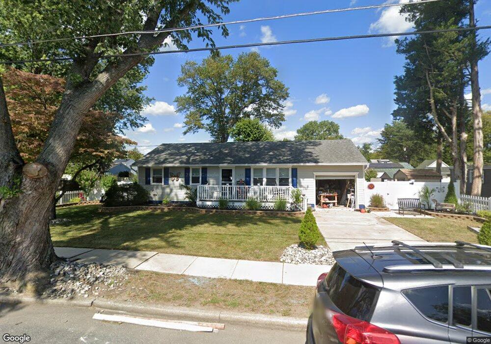
529 10th Ave Lindenwold, NJ 08021
Estimated Value: $290,244 - $324,000
--
Bed
--
Bath
1,368
Sq Ft
$225/Sq Ft
Est. Value
About This Home
This home is located at 529 10th Ave, Lindenwold, NJ 08021 and is currently estimated at $307,311, approximately $224 per square foot. 529 10th Ave is a home located in Camden County with nearby schools including Memorial Middle School, Lindenwold High School, and Saint John Paul II Regional School.
Ownership History
Date
Name
Owned For
Owner Type
Purchase Details
Closed on
Sep 7, 2000
Sold by
Alliance Funding Co
Bought by
Laganella Linda
Current Estimated Value
Purchase Details
Closed on
May 29, 1997
Sold by
Farghaly Kamel B
Bought by
Adawi Mustafa and Hamayel Sanya
Home Financials for this Owner
Home Financials are based on the most recent Mortgage that was taken out on this home.
Original Mortgage
$71,000
Interest Rate
7.98%
Create a Home Valuation Report for This Property
The Home Valuation Report is an in-depth analysis detailing your home's value as well as a comparison with similar homes in the area
Home Values in the Area
Average Home Value in this Area
Purchase History
| Date | Buyer | Sale Price | Title Company |
|---|---|---|---|
| Laganella Linda | $65,000 | -- | |
| Laganella Linda | $65,000 | -- | |
| Adawi Mustafa | $98,500 | -- |
Source: Public Records
Mortgage History
| Date | Status | Borrower | Loan Amount |
|---|---|---|---|
| Previous Owner | Adawi Mustafa | $71,000 |
Source: Public Records
Tax History Compared to Growth
Tax History
| Year | Tax Paid | Tax Assessment Tax Assessment Total Assessment is a certain percentage of the fair market value that is determined by local assessors to be the total taxable value of land and additions on the property. | Land | Improvement |
|---|---|---|---|---|
| 2025 | $6,354 | $128,500 | $40,000 | $88,500 |
| 2024 | $6,389 | $128,500 | $40,000 | $88,500 |
| 2023 | $6,389 | $128,500 | $40,000 | $88,500 |
| 2022 | $6,383 | $128,500 | $40,000 | $88,500 |
| 2021 | $6,209 | $128,500 | $40,000 | $88,500 |
| 2020 | $6,520 | $128,500 | $40,000 | $88,500 |
| 2019 | $6,578 | $128,500 | $40,000 | $88,500 |
| 2018 | $6,561 | $128,500 | $40,000 | $88,500 |
| 2017 | $6,365 | $128,500 | $40,000 | $88,500 |
| 2016 | $6,222 | $128,500 | $40,000 | $88,500 |
| 2015 | $5,941 | $128,100 | $40,000 | $88,100 |
| 2014 | $5,683 | $128,100 | $40,000 | $88,100 |
Source: Public Records
Map
Nearby Homes
- 524 8th Ave
- 441 8th Ave
- 609 8th Ave
- 413 10th Ave
- 1802 Greenwood Dr
- 2004 Greenwood Dr
- 1908 Greenwood Dr Unit C1908
- 2005 Greenwood Dr
- 409 9th Ave
- 531 6th Ave
- 2209 Greenwood Dr
- 2210 Greenwood Dr
- 2702 Greenwood Dr
- 2703 Greenwood Dr
- 2502 Greenwood Dr
- 37 Chiswick Dr
- 334 Chews Landing Rd
- 605 4th Ave
- 104 Timber Creek Rd
- 18 Glenwood Dr