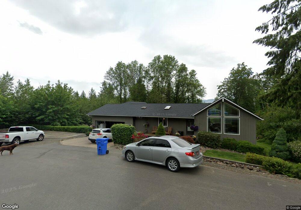
529 Powell Rd Castle Rock, WA 98611
Estimated Value: $562,000 - $940,000
4
Beds
3
Baths
1,672
Sq Ft
$399/Sq Ft
Est. Value
About This Home
This home is located at 529 Powell Rd, Castle Rock, WA 98611 and is currently estimated at $667,208, approximately $399 per square foot. 529 Powell Rd is a home located in Cowlitz County with nearby schools including Castle Rock Elementary School, Castle Rock Middle School, and Castle Rock High School.
Ownership History
Date
Name
Owned For
Owner Type
Purchase Details
Closed on
Mar 7, 2022
Sold by
Swanson Kristina
Bought by
Swanson Eric
Current Estimated Value
Purchase Details
Closed on
Jun 22, 2007
Sold by
Swanson Eric and Swanson Eric D
Bought by
Swanson Eric D and Swanson Kristina K
Home Financials for this Owner
Home Financials are based on the most recent Mortgage that was taken out on this home.
Original Mortgage
$270,000
Interest Rate
5.9%
Mortgage Type
New Conventional
Create a Home Valuation Report for This Property
The Home Valuation Report is an in-depth analysis detailing your home's value as well as a comparison with similar homes in the area
Home Values in the Area
Average Home Value in this Area
Purchase History
| Date | Buyer | Sale Price | Title Company |
|---|---|---|---|
| Swanson Eric | -- | None Listed On Document | |
| Swanson Eric D | -- | Cowlitz County Title Company |
Source: Public Records
Mortgage History
| Date | Status | Borrower | Loan Amount |
|---|---|---|---|
| Previous Owner | Swanson Eric D | $270,000 |
Source: Public Records
Tax History Compared to Growth
Tax History
| Year | Tax Paid | Tax Assessment Tax Assessment Total Assessment is a certain percentage of the fair market value that is determined by local assessors to be the total taxable value of land and additions on the property. | Land | Improvement |
|---|---|---|---|---|
| 2024 | $4,605 | $550,390 | $74,810 | $475,580 |
| 2023 | $4,363 | $548,990 | $63,400 | $485,590 |
| 2022 | $4,052 | $560,790 | $63,440 | $497,350 |
| 2021 | $4,147 | $453,520 | $55,650 | $397,870 |
| 2020 | $3,596 | $450,870 | $53,000 | $397,870 |
| 2019 | $2,989 | $405,101 | $53,000 | $352,101 |
| 2018 | $3,341 | $331,470 | $53,000 | $278,470 |
| 2017 | $2,701 | $320,660 | $50,000 | $270,660 |
| 2016 | $2,332 | $261,520 | $47,630 | $213,890 |
| 2015 | $2,319 | $242,440 | $47,630 | $194,810 |
| 2013 | -- | $238,190 | $44,100 | $194,090 |
Source: Public Records
Map
Nearby Homes
- 110 Dryad Ln
- 0 Pioneer Ave NE
- 611 Pioneer Ave NE
- 715 NE Pioneer Ave NE
- 552 North St NE
- 0 Huntington Ave S Unit NWM2336096
- 203 Roake Ave SE
- 1 D St SW
- 438 Front Ave SW
- 56 Shear St SW
- 705 1st Ave SW
- 385 Front Ave NW
- 0 Lot 6 Spirit Lake Parcel Wk3612011 Hwy
- 0 Lot 4 Spirit Lake Parcel Wk3516014 Hwy
- 0 Lot 3 Spirit Lake Parcel Wk3516013 Hwy
- 0 Lot 2 Spirit Lake Parcel Wk3516012 Hwy
- 0 Lot 5 Spirit Lake Parcel Wk3612010 Hwy
- 0 Lot 7 Spirit Lake Parcel Wk3612009 Hwy
- 1792 Spirit Lake Hwy Unit 4
- 1792 Spirit Lake Hwy Unit 3
- 513 Powell Rd
- 528 Powell Rd
- 535 Powell Rd
- 501 Powell Rd
- 502 Powell Rd
- 556 Powell Rd
- 500 Powell Rd
- 490 Powell Rd
- 188 Carpenter Rd
- 177 Carpenter Rd
- 385 Powell Rd
- 350 Powell Rd
- 172 Carpenter Rd
- 373 Powell Rd
- 145 Carpenter Rd
- 160 Carpenter Rd
- 0 Carpenter Rd Unit 29067176
- 0 Carpenter Rd Unit 14162274
- 0 Carpenter Rd Unit 16297879
- 0 Carpenter Rd Unit 17257238