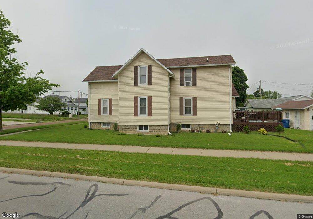
529 W 6th St Port Clinton, OH 43452
Estimated Value: $143,000 - $191,415
3
Beds
2
Baths
1,621
Sq Ft
$103/Sq Ft
Est. Value
About This Home
This home is located at 529 W 6th St, Port Clinton, OH 43452 and is currently estimated at $166,604, approximately $102 per square foot. 529 W 6th St is a home located in Ottawa County with nearby schools including Bataan Memorial Primary School, Bataan Memorial Intermediate School, and Port Clinton Middle School.
Ownership History
Date
Name
Owned For
Owner Type
Purchase Details
Closed on
Nov 8, 2024
Sold by
Domokos Lynne M and Domokos Darrell
Bought by
Hook Wesley
Current Estimated Value
Home Financials for this Owner
Home Financials are based on the most recent Mortgage that was taken out on this home.
Original Mortgage
$110,000
Outstanding Balance
$107,712
Interest Rate
6.54%
Mortgage Type
Credit Line Revolving
Estimated Equity
$58,892
Purchase Details
Closed on
Jul 1, 2015
Sold by
Domokos Darrell R
Bought by
Domokos Lynne M
Purchase Details
Closed on
Dec 31, 1992
Sold by
Buckinghan Bruce and Buckinghan Kathy
Bought by
Domokos Darrell R and Domokos Lynne M
Create a Home Valuation Report for This Property
The Home Valuation Report is an in-depth analysis detailing your home's value as well as a comparison with similar homes in the area
Home Values in the Area
Average Home Value in this Area
Purchase History
| Date | Buyer | Sale Price | Title Company |
|---|---|---|---|
| Hook Wesley | $130,000 | Chicago Title | |
| Domokos Lynne M | -- | Attorney | |
| Domokos Darrell R | $64,000 | -- |
Source: Public Records
Mortgage History
| Date | Status | Borrower | Loan Amount |
|---|---|---|---|
| Open | Hook Wesley | $110,000 |
Source: Public Records
Tax History Compared to Growth
Tax History
| Year | Tax Paid | Tax Assessment Tax Assessment Total Assessment is a certain percentage of the fair market value that is determined by local assessors to be the total taxable value of land and additions on the property. | Land | Improvement |
|---|---|---|---|---|
| 2024 | $1,773 | $48,738 | $7,938 | $40,800 |
| 2023 | $1,689 | $35,259 | $6,251 | $29,008 |
| 2022 | $1,368 | $35,259 | $6,251 | $29,008 |
| 2021 | $1,366 | $35,260 | $6,250 | $29,010 |
| 2020 | $1,120 | $30,260 | $4,810 | $25,450 |
| 2019 | $1,108 | $30,260 | $4,810 | $25,450 |
| 2018 | $1,106 | $30,260 | $4,810 | $25,450 |
| 2017 | $999 | $26,900 | $4,810 | $22,090 |
| 2016 | $1,001 | $26,900 | $4,810 | $22,090 |
| 2015 | $1,005 | $26,900 | $4,810 | $22,090 |
| 2014 | $507 | $26,900 | $4,810 | $22,090 |
| 2013 | $1,016 | $26,900 | $4,810 | $22,090 |
Source: Public Records
Map
Nearby Homes
- 515 W 6th St
- 612 Harrison St
- 326 W 4th St
- 413 W 3rd St
- 229 W 4th St
- 416 W 3rd St
- 1107 Grant St
- 1254 W Fremont Rd
- 721 Monroe St
- 820 Monroe St
- 516 Jefferson St
- 200 E 6th St
- 123 E 10th St
- 1329 S West Bay Dr
- 2565 N Peachtree Lane # Sublot 3
- 2509 N Peachtree Lane # Sublot 5
- 2537 N Peachtree Lane # Sublot 4
- 2621 N Peachtree Lane # Sublot 1
- 2397 N Peachtree Lane # Sublot 9
- 2425 N Peachtree Lane # Sublot 8