Estimated Value: $247,841 - $315,000
3
Beds
2
Baths
1,050
Sq Ft
$270/Sq Ft
Est. Value
About This Home
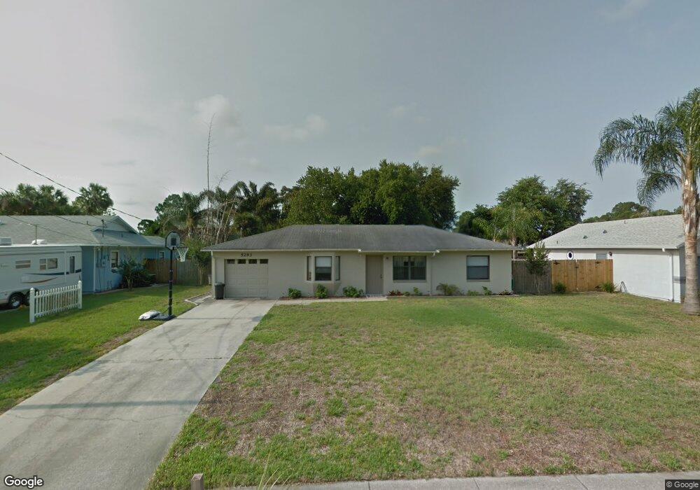
This home is located at 5293 Carrick Rd, Cocoa, FL 32927 and is currently estimated at $283,210, approximately $269 per square foot. 5293 Carrick Rd is a home located in Brevard County with nearby schools including Challenger 7 Elementary School, Space Coast Junior/Senior High School, and East Atlantic Prep of Brevard County.
Ownership History
Date
Name
Owned For
Owner Type
Purchase Details
Closed on
Apr 26, 2005
Sold by
Chastain Alfred B and Chastain Elizabeth A
Bought by
Scherer Jennifer D
Current Estimated Value
Home Financials for this Owner
Home Financials are based on the most recent Mortgage that was taken out on this home.
Original Mortgage
$127,900
Outstanding Balance
$75,124
Interest Rate
7.87%
Mortgage Type
Stand Alone First
Estimated Equity
$208,086
Create a Home Valuation Report for This Property
The Home Valuation Report is an in-depth analysis detailing your home's value as well as a comparison with similar homes in the area
Home Values in the Area
Average Home Value in this Area
Purchase History
| Date | Buyer | Sale Price | Title Company |
|---|---|---|---|
| Scherer Jennifer D | $159,900 | Liberty Title |
Source: Public Records
Mortgage History
| Date | Status | Borrower | Loan Amount |
|---|---|---|---|
| Open | Scherer Jennifer D | $127,900 |
Source: Public Records
Tax History
| Year | Tax Paid | Tax Assessment Tax Assessment Total Assessment is a certain percentage of the fair market value that is determined by local assessors to be the total taxable value of land and additions on the property. | Land | Improvement |
|---|---|---|---|---|
| 2025 | $911 | $66,100 | -- | -- |
| 2024 | $894 | $64,240 | -- | -- |
| 2023 | $894 | $62,370 | $0 | $0 |
| 2022 | $848 | $60,560 | $0 | $0 |
| 2021 | $850 | $58,800 | $0 | $0 |
| 2020 | $817 | $57,990 | $0 | $0 |
| 2019 | $765 | $56,690 | $0 | $0 |
| 2018 | $766 | $55,640 | $0 | $0 |
| 2017 | $769 | $54,500 | $0 | $0 |
| 2016 | $774 | $53,380 | $18,000 | $35,380 |
| 2015 | $778 | $53,010 | $15,000 | $38,010 |
| 2014 | $783 | $52,590 | $11,000 | $41,590 |
Source: Public Records
Map
Nearby Homes
- 5221 Carrick Rd
- 6020 Cannon Ave
- 5215 Holden Rd
- 5220 Holden Rd
- 5945 Coker Ave
- 5950 Ackard Ave
- 5946 Deer Ln
- 6094 Cardiff Ave
- 6438 Hudson Rd
- 5601 Banos Ave
- 6450 Ember Ave
- 4975 Fay Blvd
- 6375 Cable Ave
- 6210 Stillwater Ave
- 00 Unknown
- 5914 Stillwater Ave
- 5680 Banos Ave
- 6481 La Brea Ave
- 5720 Flint Rd
- 5265 Fay Blvd
- 5281 Carrick Rd
- 5336 Carrick Rd
- 5296 Maravoss St
- 5284 Maravoss St
- 5308 Maravoss St
- 5305 Carrick Rd Unit 1
- 5305 Carrick Rd
- 5269 Carrick Rd
- 5317 Carrick Rd
- 5280 Carrick Rd
- 5300 Carrick Rd
- 5272 Maravoss St
- 5320 Maravoss St
- 5260 Carrick Rd
- 5310 Carrick Rd
- 5329 Carrick Rd
- 5257 Carrick Rd
- 5260 Maravoss St
- 5351 Maravoss St
- 5332 Maravoss St
Your Personal Tour Guide
Ask me questions while you tour the home.