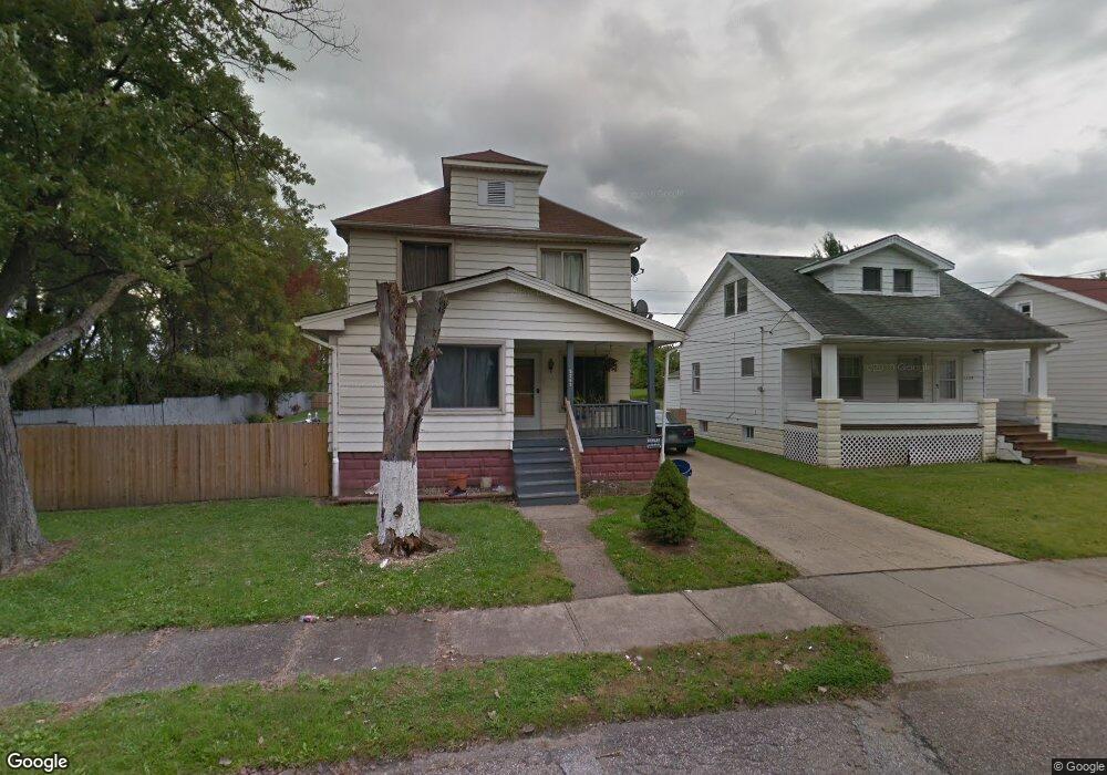
5293 Kohout St Maple Heights, OH 44137
Estimated Value: $105,000 - $139,000
3
Beds
1
Bath
1,248
Sq Ft
$93/Sq Ft
Est. Value
About This Home
This home is located at 5293 Kohout St, Maple Heights, OH 44137 and is currently estimated at $116,291, approximately $93 per square foot. 5293 Kohout St is a home located in Cuyahoga County with nearby schools including Abraham Lincoln Elementary School, Rockside/ J.F. Kennedy School, and Barack Obama School.
Ownership History
Date
Name
Owned For
Owner Type
Purchase Details
Closed on
Oct 4, 2007
Sold by
Household Realty Corp
Bought by
Varga Csaba
Current Estimated Value
Purchase Details
Closed on
May 1, 2007
Sold by
Muzic Albert P and Muzic Patricia A
Bought by
Household Realty Corp
Purchase Details
Closed on
Sep 28, 1989
Sold by
Pasacic Thom J and Pasacic Martha E
Bought by
Hager Robert
Purchase Details
Closed on
Jan 1, 1975
Bought by
Pasacic Thom J and Pasacic Martha E
Create a Home Valuation Report for This Property
The Home Valuation Report is an in-depth analysis detailing your home's value as well as a comparison with similar homes in the area
Home Values in the Area
Average Home Value in this Area
Purchase History
| Date | Buyer | Sale Price | Title Company |
|---|---|---|---|
| Varga Csaba | $15,000 | Resource Title Agency Inc | |
| Household Realty Corp | $53,334 | Resource Title Agency Inc | |
| Hager Robert | -- | -- | |
| Pasacic Thom J | -- | -- |
Source: Public Records
Tax History Compared to Growth
Tax History
| Year | Tax Paid | Tax Assessment Tax Assessment Total Assessment is a certain percentage of the fair market value that is determined by local assessors to be the total taxable value of land and additions on the property. | Land | Improvement |
|---|---|---|---|---|
| 2024 | $3,004 | $32,165 | $7,070 | $25,095 |
| 2023 | $1,767 | $15,130 | $4,170 | $10,960 |
| 2022 | $1,761 | $15,120 | $4,170 | $10,960 |
| 2021 | $1,871 | $15,120 | $4,170 | $10,960 |
| 2020 | $1,613 | $11,450 | $3,150 | $8,300 |
| 2019 | $1,603 | $32,700 | $9,000 | $23,700 |
| 2018 | $1,594 | $11,450 | $3,150 | $8,300 |
| 2017 | $1,411 | $9,560 | $3,990 | $5,570 |
| 2016 | $1,365 | $9,560 | $3,990 | $5,570 |
| 2015 | $1,429 | $9,560 | $3,990 | $5,570 |
| 2014 | $1,429 | $9,840 | $4,130 | $5,710 |
Source: Public Records
Map
Nearby Homes
- 15095 Granger Rd
- 14567 Pease Rd
- 14305 Granger Rd
- 5251 Forest Ave
- 5220 Forest Ave
- 5100 Greenhurst Dr
- 5197 Milo Ave
- 15911 Friend Ave
- 13704 Linn Ave
- 14417 Corridon Ave
- 16174 Friendly St
- 15505 Benhoff Dr
- 5270 E 135th St
- 16241 Glenburn Ave
- 5210 Theodore St
- 13917 Maple Leaf Dr
- 4955 E 141st St
- 14404 Tokay Ave
- 13300 Shady Oak Blvd
- 13616 Oakview Blvd
- 5299 Kohout St
- 5303 Kohout St
- 5303 Kohout St Unit 19
- 5305 Kohout St
- 5310 Meadow St
- 5314 Meadow St
- 5311 Kohout St
- 5322 Meadow St
- 5298 Kohout St
- 5302 Kohout St
- 5313 Kohout St
- 5326 Meadow St
- 5306 Kohout St
- 5317 Kohout St
- 5330 Meadow St
- 5314 Kohout St
- 5334 Meadow St
- 5321 Kohout St
- 5316 Kohout St
- 5323 Meadow St