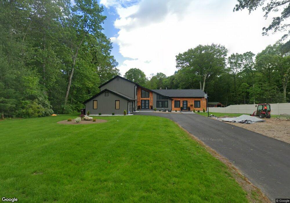
53 Christopher Dr Westfield, MA 01085
Estimated Value: $465,000 - $683,000
3
Beds
2
Baths
2,966
Sq Ft
$198/Sq Ft
Est. Value
About This Home
This home is located at 53 Christopher Dr, Westfield, MA 01085 and is currently estimated at $586,286, approximately $197 per square foot. 53 Christopher Dr is a home located in Hampden County with nearby schools including Westfield High School and Saint Mary High School.
Ownership History
Date
Name
Owned For
Owner Type
Purchase Details
Closed on
Dec 5, 2022
Sold by
Ma Xiuyu
Bought by
Williams Bobby R
Current Estimated Value
Home Financials for this Owner
Home Financials are based on the most recent Mortgage that was taken out on this home.
Original Mortgage
$390,000
Outstanding Balance
$378,297
Interest Rate
6.95%
Mortgage Type
Purchase Money Mortgage
Estimated Equity
$207,989
Purchase Details
Closed on
Dec 15, 2003
Sold by
Perron Lanny C
Bought by
Ma Xiuyu
Purchase Details
Closed on
Jan 14, 1991
Sold by
Tutt John B
Bought by
Perron Lanny C
Home Financials for this Owner
Home Financials are based on the most recent Mortgage that was taken out on this home.
Original Mortgage
$180,000
Interest Rate
9.83%
Mortgage Type
Purchase Money Mortgage
Create a Home Valuation Report for This Property
The Home Valuation Report is an in-depth analysis detailing your home's value as well as a comparison with similar homes in the area
Home Values in the Area
Average Home Value in this Area
Purchase History
| Date | Buyer | Sale Price | Title Company |
|---|---|---|---|
| Williams Bobby R | $390,000 | None Available | |
| Ma Xiuyu | $235,000 | -- | |
| Perron Lanny C | $200,000 | -- |
Source: Public Records
Mortgage History
| Date | Status | Borrower | Loan Amount |
|---|---|---|---|
| Open | Williams Bobby R | $390,000 | |
| Previous Owner | Perron Lanny C | $178,200 | |
| Previous Owner | Perron Lanny C | $180,000 | |
| Closed | Perron Lanny C | $12,500 |
Source: Public Records
Tax History Compared to Growth
Tax History
| Year | Tax Paid | Tax Assessment Tax Assessment Total Assessment is a certain percentage of the fair market value that is determined by local assessors to be the total taxable value of land and additions on the property. | Land | Improvement |
|---|---|---|---|---|
| 2025 | $7,762 | $511,300 | $139,300 | $372,000 |
| 2024 | $6,163 | $385,900 | $127,100 | $258,800 |
| 2023 | $59 | $358,900 | $121,000 | $237,900 |
| 2022 | $5,867 | $317,300 | $107,500 | $209,800 |
| 2021 | $5,681 | $300,900 | $101,400 | $199,500 |
| 2020 | $5,729 | $297,600 | $101,400 | $196,200 |
| 2019 | $5,596 | $284,500 | $96,600 | $187,900 |
| 2018 | $5,508 | $284,500 | $96,600 | $187,900 |
| 2017 | $5,389 | $277,500 | $97,900 | $179,600 |
| 2016 | $5,395 | $277,500 | $97,900 | $179,600 |
| 2015 | $4,911 | $264,900 | $97,900 | $167,000 |
| 2014 | $4,816 | $264,900 | $97,900 | $167,000 |
Source: Public Records
Map
Nearby Homes
- 242 Eastwood Dr
- 99 Hillcrest Cir
- 120 Woodcliff Dr
- 346 E Mountain Rd
- 0 Little River Road ( Rear )
- 0 Holyoke Rd
- 26 Deepwoods Dr
- 0 E Mountain Rd
- 14 Lynnwood Dr
- 119 Union St Unit 4
- 111 Union St Unit 6
- 103 Feeding Hills Rd
- 0 Feeding Hills Rd
- 138 Main St Unit 13
- 138 Main St Unit 11
- 99 Woodmont St
- 13 William St
- 20 Greenwood St Unit 10
- 72-74 Notre Dame St
- 514 Dewey St
- 59 Christopher Dr
- 47 Christopher Dr
- 56 Christopher Dr
- 65 Christopher Dr
- 46 Christopher Dr
- 66 Christopher Dr
- 71 Christopher Dr
- 35 Christopher Dr
- 12 Amy Dr
- 40 Christopher Dr
- 11 Amy Dr
- 77 Christopher Dr
- 49 Briarcliff Dr
- 45 Briarcliff Dr
- 72 Christopher Dr
- 53 Briarcliff Dr
- 41 Briarcliff Dr
- 83 Christopher Dr
- 32 Christopher Dr
- 37 Briarcliff Dr