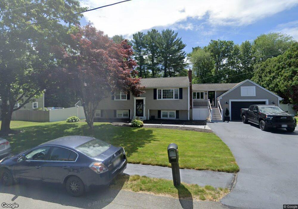
53 Country Way Whitman, MA 02382
Estimated Value: $617,334 - $710,000
3
Beds
2
Baths
1,902
Sq Ft
$352/Sq Ft
Est. Value
About This Home
This home is located at 53 Country Way, Whitman, MA 02382 and is currently estimated at $669,084, approximately $351 per square foot. 53 Country Way is a home located in Plymouth County with nearby schools including St Bridget School.
Ownership History
Date
Name
Owned For
Owner Type
Purchase Details
Closed on
Apr 11, 2023
Sold by
Mcmanue Kieren F
Bought by
Mcmanue Kieren F and Smith Melissa
Current Estimated Value
Purchase Details
Closed on
Apr 23, 2015
Sold by
Meinhold Melissa E and Mcmanus Kieren F
Bought by
Mcmanus 3Rd Kieren F
Purchase Details
Closed on
Apr 30, 2009
Sold by
Cusick David W and Ceurvels-Cusick Mona E
Bought by
Meinhold Melissa E and Mcmanus Kieren F
Home Financials for this Owner
Home Financials are based on the most recent Mortgage that was taken out on this home.
Original Mortgage
$309,294
Interest Rate
4.86%
Mortgage Type
Purchase Money Mortgage
Purchase Details
Closed on
Apr 25, 2008
Sold by
Cusick David W and Cuervels-Cusick Mona E
Bought by
Cusick David W and Cuervels-Cusick Mona E
Purchase Details
Closed on
May 13, 1988
Sold by
Pompeo John J
Bought by
Cusick David W
Create a Home Valuation Report for This Property
The Home Valuation Report is an in-depth analysis detailing your home's value as well as a comparison with similar homes in the area
Home Values in the Area
Average Home Value in this Area
Purchase History
| Date | Buyer | Sale Price | Title Company |
|---|---|---|---|
| Mcmanue Kieren F | -- | None Available | |
| Mcmanus 3Rd Kieren F | -- | -- | |
| Meinhold Melissa E | $315,000 | -- | |
| Cusick David W | -- | -- | |
| Cusick David W | $165,000 | -- |
Source: Public Records
Mortgage History
| Date | Status | Borrower | Loan Amount |
|---|---|---|---|
| Previous Owner | Cusick David W | $309,294 | |
| Previous Owner | Cusick David W | $150,000 | |
| Previous Owner | Cusick David W | $111,000 |
Source: Public Records
Tax History Compared to Growth
Tax History
| Year | Tax Paid | Tax Assessment Tax Assessment Total Assessment is a certain percentage of the fair market value that is determined by local assessors to be the total taxable value of land and additions on the property. | Land | Improvement |
|---|---|---|---|---|
| 2025 | $7,224 | $550,600 | $223,700 | $326,900 |
| 2024 | $6,365 | $499,600 | $219,300 | $280,300 |
| 2023 | $5,687 | $419,100 | $190,200 | $228,900 |
| 2022 | $5,441 | $373,700 | $172,900 | $200,800 |
| 2021 | $5,791 | $373,600 | $167,500 | $206,100 |
| 2020 | $5,603 | $353,500 | $158,800 | $194,700 |
| 2019 | $5,380 | $349,800 | $158,800 | $191,000 |
| 2018 | $5,222 | $326,200 | $151,300 | $174,900 |
| 2017 | $4,919 | $326,200 | $151,300 | $174,900 |
| 2016 | $4,641 | $297,700 | $135,100 | $162,600 |
| 2015 | $4,525 | $289,900 | $135,100 | $154,800 |
Source: Public Records
Map
Nearby Homes
- 101 Washington St Unit 4
- 22 Old Coach Rd
- Plan B Northville Village Unit Plan B
- Unit 12 Northville Village Unit 12
- Unit 11 Northville Village Unit 11
- 154 Auburn St
- 159 Auburn St
- Plan A Northville Village Unit Plan A
- Plan A Northville Village
- 150 Harvard St
- 20 Elm Place
- 572 Harvard St
- 48 Day St
- 35 Dana St
- 110 South Ave Unit 14
- 110 South Ave
- 214 Winter St
- 53 Temple St
- 126-130 Franklin St
- 501 Auburn St Unit 404