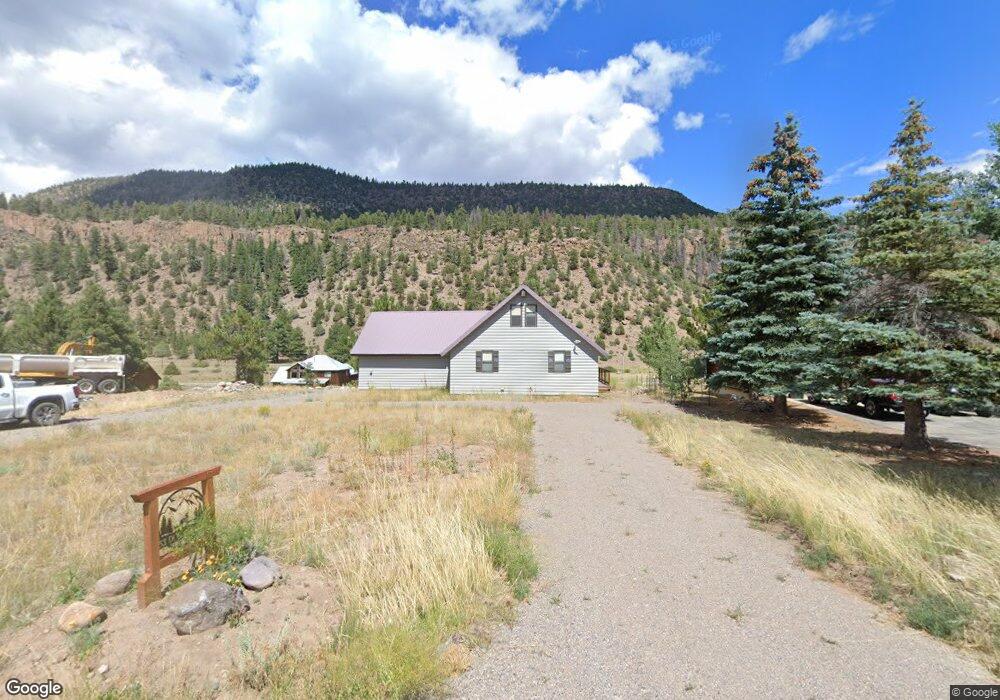
53 Doe Cir South Fork, CO 81154
Estimated Value: $492,206 - $595,000
3
Beds
2
Baths
1,399
Sq Ft
$396/Sq Ft
Est. Value
About This Home
This home is located at 53 Doe Cir, South Fork, CO 81154 and is currently estimated at $553,552, approximately $395 per square foot. 53 Doe Cir is a home located in Rio Grande County with nearby schools including Del Norte K-8 School and Del Norte High School.
Ownership History
Date
Name
Owned For
Owner Type
Purchase Details
Closed on
Sep 8, 2021
Sold by
Gooding Allen W and Hamilton Desiree
Bought by
Davidson James Yoneji
Current Estimated Value
Purchase Details
Closed on
Dec 12, 2006
Sold by
Hill Family Trust
Bought by
Gooding Allen W and Hamilton Desiree
Home Financials for this Owner
Home Financials are based on the most recent Mortgage that was taken out on this home.
Original Mortgage
$3,365
Interest Rate
7%
Mortgage Type
Purchase Money Mortgage
Create a Home Valuation Report for This Property
The Home Valuation Report is an in-depth analysis detailing your home's value as well as a comparison with similar homes in the area
Home Values in the Area
Average Home Value in this Area
Purchase History
| Date | Buyer | Sale Price | Title Company |
|---|---|---|---|
| Davidson James Yoneji | $425,000 | None Available | |
| Gooding Allen W | $33,000 | None Available |
Source: Public Records
Mortgage History
| Date | Status | Borrower | Loan Amount |
|---|---|---|---|
| Previous Owner | Gooding Allen W | $3,365 |
Source: Public Records
Tax History Compared to Growth
Tax History
| Year | Tax Paid | Tax Assessment Tax Assessment Total Assessment is a certain percentage of the fair market value that is determined by local assessors to be the total taxable value of land and additions on the property. | Land | Improvement |
|---|---|---|---|---|
| 2024 | $1,839 | $28,354 | $9,161 | $19,193 |
| 2023 | $1,839 | $28,354 | $9,161 | $19,193 |
| 2022 | $1,309 | $20,128 | $5,694 | $14,434 |
| 2021 | $1,325 | $20,708 | $5,858 | $14,850 |
| 2020 | $1,425 | $22,177 | $5,858 | $16,319 |
| 2019 | $1,427 | $22,177 | $5,858 | $16,319 |
| 2018 | $1,412 | $21,823 | $0 | $0 |
| 2017 | $1,424 | $21,823 | $0 | $0 |
| 2016 | $1,131 | $22,396 | $0 | $0 |
| 2015 | $1,151 | $22,396 | $0 | $0 |
| 2014 | $1,151 | $22,723 | $0 | $0 |
| 2013 | $1,017 | $22,723 | $0 | $0 |
Source: Public Records
Map
Nearby Homes
- TBD Colorado 149
- 120 East St
- 59 Spruce Dr W
- 7 Cottonwood Dr
- 328 Fir Dr
- 0 Ellingwood Dr Unit 829439
- 164 Woodchuck Dr
- TBD Little Bear Circle Lot 55
- TBD Little Bear Circle Lot 54
- 0 Aspen Dr
- 0253 Aspen Cir
- 152 Conifer Dr
- TBD Little Bear Circle Lot 41
- 580 Blanca Vista Dr
- 530 Blanca Vista Dr
- 548 Blanca Vista Dr
- 44 Hopi Ct
- 136 Hopi Ct
- 65 Timberline Trail
- 222 Bristle Cone Dr