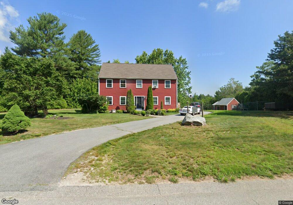
53 Malbone Rd Assonet, MA 02702
Estimated Value: $568,000 - $722,085
3
Beds
2
Baths
1,056
Sq Ft
$605/Sq Ft
Est. Value
About This Home
This home is located at 53 Malbone Rd, Assonet, MA 02702 and is currently estimated at $638,771, approximately $604 per square foot. 53 Malbone Rd is a home located in Bristol County with nearby schools including Freetown Elementary School, George R Austin Intermediate School, and Freetown-Lakeville Middle School.
Ownership History
Date
Name
Owned For
Owner Type
Purchase Details
Closed on
Sep 3, 2021
Sold by
Smith Thomas E and Gilhooly-Smith Erin M
Bought by
Gilhooly-Smith Erin M
Current Estimated Value
Purchase Details
Closed on
Jul 10, 2006
Sold by
Escobar David J and Escobar Dawn M
Bought by
Gilhooly-Smith Erin M and Smith Thomas E
Home Financials for this Owner
Home Financials are based on the most recent Mortgage that was taken out on this home.
Original Mortgage
$246,400
Interest Rate
6.6%
Mortgage Type
Purchase Money Mortgage
Purchase Details
Closed on
Apr 23, 1993
Sold by
Assonet Land Dev Corp
Bought by
Moniz Robert J and Moniz Sharon M
Purchase Details
Closed on
Jan 24, 1992
Sold by
Moniz Stephen
Bought by
Escobar David J and Escobar Dawn M
Purchase Details
Closed on
May 15, 1991
Sold by
Freetown Sand & Gravel
Bought by
Moniz Stephen
Create a Home Valuation Report for This Property
The Home Valuation Report is an in-depth analysis detailing your home's value as well as a comparison with similar homes in the area
Purchase History
| Date | Buyer | Sale Price | Title Company |
|---|---|---|---|
| Gilhooly-Smith Erin M | -- | None Available | |
| Gilhooly-Smith Erin M | $308,000 | -- | |
| Moniz Robert J | $58,000 | -- | |
| Escobar David J | $117,000 | -- | |
| Moniz Stephen | $57,000 | -- |
Source: Public Records
Mortgage History
| Date | Status | Borrower | Loan Amount |
|---|---|---|---|
| Previous Owner | Gilhooly-Smith Erin M | $246,400 | |
| Previous Owner | Moniz Stephen | $25,000 | |
| Previous Owner | Moniz Stephen | $120,000 |
Source: Public Records
Tax History
| Year | Tax Paid | Tax Assessment Tax Assessment Total Assessment is a certain percentage of the fair market value that is determined by local assessors to be the total taxable value of land and additions on the property. | Land | Improvement |
|---|---|---|---|---|
| 2025 | $6,780 | $684,200 | $235,900 | $448,300 |
| 2024 | $6,788 | $650,800 | $222,500 | $428,300 |
| 2023 | $6,589 | $615,200 | $200,400 | $414,800 |
| 2022 | $6,359 | $527,300 | $169,600 | $357,700 |
| 2021 | $6,189 | $487,300 | $154,200 | $333,100 |
| 2020 | $6,143 | $471,800 | $148,100 | $323,700 |
| 2019 | $5,950 | $452,500 | $146,700 | $305,800 |
| 2018 | $5,691 | $427,600 | $146,700 | $280,900 |
| 2017 | $5,544 | $416,200 | $146,700 | $269,500 |
| 2016 | $5,324 | $406,700 | $142,500 | $264,200 |
| 2015 | $5,225 | $405,000 | $142,500 | $262,500 |
| 2014 | $5,084 | $403,200 | $145,000 | $258,200 |
Source: Public Records
Map
Nearby Homes
- 52 Anthony St
- 0 Sammys Ln
- 23 Elmwood Dr
- 37 Simpson Ln
- 71 County St
- 5 Hadley Heights Way
- 16 Water St Unit C
- 16 Water St Unit A
- 16 Water St Unit B
- 16 Water St Unit D
- 4 Hadley Heights Way
- 73 Seymour St
- 42 High St
- 145 County St
- 24 Bells Brook Rd
- 66 S Main St
- 1969 County St
- 73 Bayview Ave
- 4 Narrows Rd
- 47 Narrows Rd
Your Personal Tour Guide
Ask me questions while you tour the home.