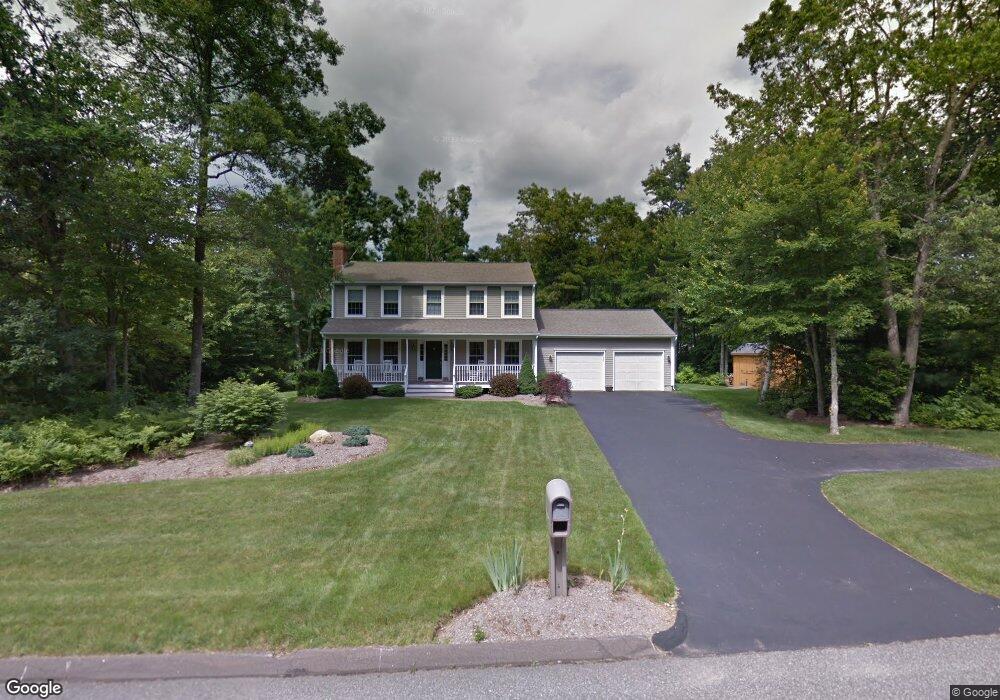
53 Mt Laurel Dr Tolland, CT 06084
Estimated Value: $508,000 - $579,000
4
Beds
3
Baths
1,942
Sq Ft
$274/Sq Ft
Est. Value
About This Home
This home is located at 53 Mt Laurel Dr, Tolland, CT 06084 and is currently estimated at $533,063, approximately $274 per square foot. 53 Mt Laurel Dr is a home located in Tolland County with nearby schools including Tolland High School.
Ownership History
Date
Name
Owned For
Owner Type
Purchase Details
Closed on
Oct 12, 2006
Sold by
Brigham Robert and Brigham Jennifer
Bought by
Otis Brian and Otis Gail
Current Estimated Value
Home Financials for this Owner
Home Financials are based on the most recent Mortgage that was taken out on this home.
Original Mortgage
$280,000
Interest Rate
6.47%
Purchase Details
Closed on
Sep 16, 2004
Sold by
Reilly Joseph and Reilly Kim
Bought by
Brigham Robert and Brigham Jennifer
Purchase Details
Closed on
May 21, 2001
Sold by
Clh Const Llc
Bought by
Reilly Joseph and Reilly Kim
Create a Home Valuation Report for This Property
The Home Valuation Report is an in-depth analysis detailing your home's value as well as a comparison with similar homes in the area
Home Values in the Area
Average Home Value in this Area
Purchase History
We collect this data history from publicly available records. To have your information removed, we recommend requesting removal directly through your county’s website.
| Date | Buyer | Sale Price | Title Company |
|---|---|---|---|
| Otis Brian | $350,000 | -- | |
| Otis Brian | $350,000 | -- | |
| Brigham Robert | $324,900 | -- | |
| Brigham Robert | $324,900 | -- | |
| Reilly Joseph | $232,000 | -- | |
| Clh Const | $59,000 | -- |
Source: Public Records
Mortgage History
We collect this data history from publicly available records. To have your information removed, we recommend requesting removal directly through your county’s website.
| Date | Status | Borrower | Loan Amount |
|---|---|---|---|
| Open | Clh Const | $340,500 | |
| Closed | Clh Const | $280,000 |
Source: Public Records
Tax History
| Year | Tax Paid | Tax Assessment Tax Assessment Total Assessment is a certain percentage of the fair market value that is determined by local assessors to be the total taxable value of land and additions on the property. | Land | Improvement |
|---|---|---|---|---|
| 2025 | $8,491 | $312,300 | $77,100 | $235,200 |
| 2024 | $8,019 | $212,300 | $73,400 | $138,900 |
| 2023 | $7,925 | $212,300 | $73,400 | $138,900 |
| 2022 | $7,766 | $212,300 | $73,400 | $138,900 |
| 2021 | $7,878 | $212,300 | $73,400 | $138,900 |
| 2020 | $7,653 | $212,300 | $73,400 | $138,900 |
| 2019 | $7,945 | $220,400 | $75,700 | $144,700 |
| 2018 | $7,714 | $220,400 | $75,700 | $144,700 |
| 2017 | $7,535 | $220,400 | $75,700 | $144,700 |
| 2016 | $7,535 | $220,400 | $75,700 | $144,700 |
| 2015 | $7,353 | $220,400 | $75,700 | $144,700 |
| 2014 | $7,247 | $233,400 | $84,100 | $149,300 |
Source: Public Records
Map
Nearby Homes
- 45 Mountain Laurel Dr
- 515 Buff Cap Rd
- 8 Neff Hill Rd
- 0 Tolland Turnpike
- 41 Neff Hill Rd
- 15 Usher Ridge
- 68 Usher Ridge
- 36 Usher Ridge
- 110 Neff Hill Rd
- 105 Neff Hill Rd
- 137 Neff Hill Rd
- 77 Neff Hill Rd
- 100 Neff Hill Rd
- 84 Neff Hill Rd
- 71 Neff Hill Rd
- 51 Sandy Beach Rd
- 50 Buff Cap Rd
- 109 Tolland Ave
- 50 Cook Rd
- 457 Old Stafford Rd
- 58 Mt Laurel Dr
- 50 Mt Laurel Dr
- 58 Mountain Laurel Dr
- 66 Mt Laurel Dr
- 45 Mt Laurel Dr
- 65 Mt Laurel Dr
- 44 Mt Laurel Dr
- 66 Mt Laurel Dr
- 73 Deerwood Rd
- 12 Mountain Laurel Dr
- 37 Mt Laurel Dr
- 37 Mountain Laurel Dr
- 91 Deerwood Rd
- 65 Deerwood Rd
- 36 Mt Laurel Dr
- 73 Mt Laurel Dr
- 158 Charles St
- 74 Mt Laurel Dr
- 150 Charles St
- 166 Charles St
Your Personal Tour Guide
Ask me questions while you tour the home.