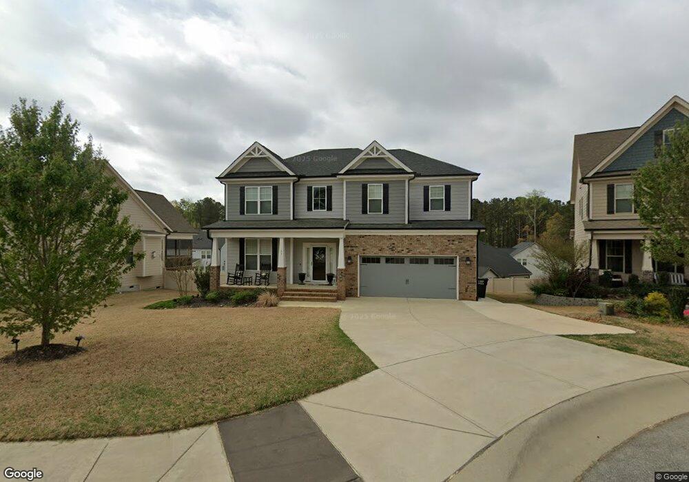
53 Rambo Cir Garner, NC 27529
Estimated Value: $495,822 - $559,000
4
Beds
3
Baths
2,950
Sq Ft
$178/Sq Ft
Est. Value
About This Home
This home is located at 53 Rambo Cir, Garner, NC 27529 and is currently estimated at $526,206, approximately $178 per square foot. 53 Rambo Cir is a home located in Johnston County with nearby schools including West View Elementary School, Cleveland Middle School, and West Johnston High School.
Ownership History
Date
Name
Owned For
Owner Type
Purchase Details
Closed on
Jan 30, 2026
Sold by
Adams Lecarlos A and Adams Nikki K
Bought by
Adams Family Trust and Adams
Current Estimated Value
Purchase Details
Closed on
Mar 18, 2020
Sold by
Waterford Green Communities Of Nc Llc
Bought by
Adams Lecarlos A and Adams Nikid K
Home Financials for this Owner
Home Financials are based on the most recent Mortgage that was taken out on this home.
Original Mortgage
$348,078
Interest Rate
3.4%
Mortgage Type
FHA
Purchase Details
Closed on
Jan 30, 2019
Sold by
Carroll Construction Homes Inc
Bought by
Waterford Green Communities Of Nc Llc
Home Financials for this Owner
Home Financials are based on the most recent Mortgage that was taken out on this home.
Original Mortgage
$11,550,000
Interest Rate
4.5%
Mortgage Type
Purchase Money Mortgage
Purchase Details
Closed on
Jan 10, 2018
Sold by
Dj 4042 Inc
Bought by
Carroll Construction Homes Inc
Create a Home Valuation Report for This Property
The Home Valuation Report is an in-depth analysis detailing your home's value as well as a comparison with similar homes in the area
Home Values in the Area
Average Home Value in this Area
Purchase History
| Date | Buyer | Sale Price | Title Company |
|---|---|---|---|
| Adams Family Trust | -- | None Listed On Document | |
| Adams Lecarlos A | $354,500 | None Available | |
| Waterford Green Communities Of Nc Llc | $1,001,000 | None Available | |
| Carroll Construction Homes Inc | $416,000 | None Available |
Source: Public Records
Mortgage History
| Date | Status | Borrower | Loan Amount |
|---|---|---|---|
| Previous Owner | Adams Lecarlos A | $348,078 | |
| Previous Owner | Waterford Green Communities Of Nc Llc | $11,550,000 |
Source: Public Records
Tax History
| Year | Tax Paid | Tax Assessment Tax Assessment Total Assessment is a certain percentage of the fair market value that is determined by local assessors to be the total taxable value of land and additions on the property. | Land | Improvement |
|---|---|---|---|---|
| 2025 | $3,267 | $514,430 | $70,000 | $444,430 |
| 2024 | $2,786 | $343,990 | $50,000 | $293,990 |
| 2023 | $2,692 | $343,990 | $50,000 | $293,990 |
| 2022 | $2,829 | $343,990 | $50,000 | $293,990 |
| 2021 | $2,829 | $343,990 | $50,000 | $293,990 |
| 2020 | $2,794 | $335,630 | $50,000 | $285,630 |
| 2019 | $416 | $50,000 | $50,000 | $0 |
| 2018 | $426 | $50,000 | $50,000 | $0 |
Source: Public Records
Map
Nearby Homes
- 403 Airedale Trail
- 49 Dandy Flush Ct
- 356 Fieldtrial Cir
- 236 Fieldtrial Cir
- 72 Meadowmist Dr
- 648 Fieldtrial Cir
- 232 Fawn Hill Ct
- 181 Fawn Hill Ct
- 58 Trailblazer Ln
- 113 Hogan Dr
- 562 Pierce Rd
- 866 Black Angus Dr
- 48 Banbury Ct
- 94 Shady Creek Trail
- 242 Thornwhistle Place
- 11 Forest Meadow Ct
- 111 Artic Cir
- 106 Par Cir
- 131 Artic Cir
- 421 Danielle Dr
- 63 Rambo Cir
- 39 Rambo Cir
- 71 Rambo Cir
- 48 Rambo Cir
- 58 Rambo Cir
- 66 Rambo Cir
- 27 Rambo Cir
- 34 Rambo Cir
- 74 Maximus Cir Unit LOT 371 (ASH/C)
- 74 Maximus Cir
- 62 Maximus Cir
- 16 Rambo Cir
- 13 Rambo Cir
- 80 Maximus Cir
- 50 Maximus Cir Unit LOT 373 (CHESTNUT/A)
- 50 Maximus Cir
- 1116 Airedale Trail
- 1102 Airedale Trail
- 32 Maximus Cir Unit LOT 374 (MAPLE/C)
- 32 Maximus Cir
Your Personal Tour Guide
Ask me questions while you tour the home.