Estimated Value: $784,022 - $966,000
Studio
--
Bath
2,370
Sq Ft
$352/Sq Ft
Est. Value
About This Home
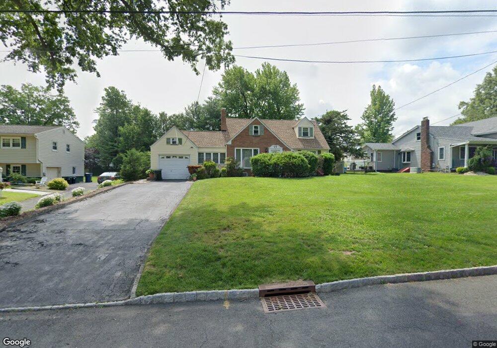
This home is located at 53 Ridge Rd, Clark, NJ 07066 and is currently estimated at $833,506, approximately $351 per square foot. 53 Ridge Rd is a home located in Union County with nearby schools including Frank K. Hehnly Elementary School, Carl H. Kumpf Middle School, and Arthur L. Johnson High School.
Ownership History
Date
Name
Owned For
Owner Type
Purchase Details
Closed on
Jun 1, 1999
Sold by
Mayer Julius Robert and Mayer Bonnie E
Bought by
Wright Kenneth C and Wright Agnes M
Current Estimated Value
Home Financials for this Owner
Home Financials are based on the most recent Mortgage that was taken out on this home.
Original Mortgage
$50,000
Interest Rate
6.85%
Purchase Details
Closed on
Jun 24, 1994
Sold by
Pigliacelli Alfred J and Pigliacelli Lissette A
Bought by
Mayer Julius Robert and Mayer Bonnie E
Create a Home Valuation Report for This Property
The Home Valuation Report is an in-depth analysis detailing your home's value as well as a comparison with similar homes in the area
Home Values in the Area
Average Home Value in this Area
Purchase History
| Date | Buyer | Sale Price | Title Company |
|---|---|---|---|
| Wright Kenneth C | $293,000 | Chicago Title Insurance Co | |
| Mayer Julius Robert | $257,000 | -- |
Source: Public Records
Mortgage History
| Date | Status | Borrower | Loan Amount |
|---|---|---|---|
| Closed | Wright Kenneth C | $50,000 |
Source: Public Records
Tax History
| Year | Tax Paid | Tax Assessment Tax Assessment Total Assessment is a certain percentage of the fair market value that is determined by local assessors to be the total taxable value of land and additions on the property. | Land | Improvement |
|---|---|---|---|---|
| 2025 | $13,893 | $627,500 | $313,600 | $313,900 |
| 2024 | $13,686 | $627,500 | $313,600 | $313,900 |
| 2023 | $13,686 | $627,500 | $313,600 | $313,900 |
| 2022 | $13,290 | $627,500 | $313,600 | $313,900 |
| 2021 | $12,553 | $141,200 | $48,000 | $93,200 |
| 2020 | $12,348 | $141,200 | $48,000 | $93,200 |
| 2019 | $12,224 | $141,200 | $48,000 | $93,200 |
| 2018 | $12,077 | $141,200 | $48,000 | $93,200 |
| 2017 | $11,883 | $141,200 | $48,000 | $93,200 |
| 2016 | $11,446 | $141,200 | $48,000 | $93,200 |
| 2015 | $11,330 | $141,200 | $48,000 | $93,200 |
| 2014 | $11,091 | $141,200 | $48,000 | $93,200 |
Source: Public Records
Map
Nearby Homes
- 27 Stemmer Dr
- 675 Raritan Rd Unit 12
- 20 Alastair Place
- 279 Madison Hill Rd
- 17 Rolling Hill Way
- 155 Meadow Rd
- 112 W Willow St
- 64 William St
- 131 Morningside Rd
- 116 Arthur Ave
- 172 Briarheath Ln
- 24 Frederick Ave
- 15 E Walnut St
- 8 Normandy Rd
- 26 Linda Ave
- 81 Hutchinson St
- 237 Carolyn Ave
- 5 Winters Ct Unit 7
- 8 Maddaket
- 125 Kimberly Rd
Your Personal Tour Guide
Ask me questions while you tour the home.