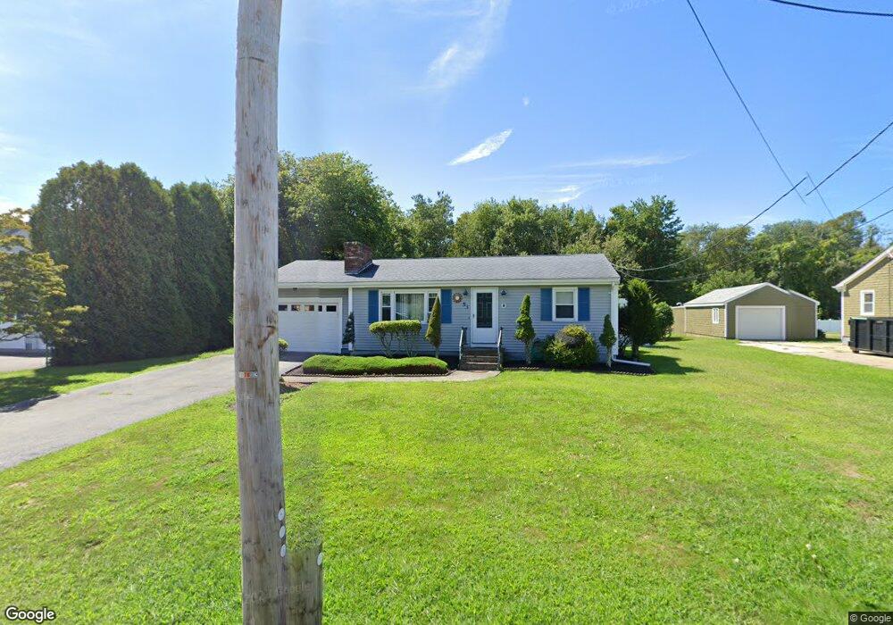
53 Sodom Rd Westport, MA 02790
Sawdy Pond/Woods Corner NeighborhoodEstimated Value: $397,000 - $684,000
2
Beds
1
Bath
816
Sq Ft
$601/Sq Ft
Est. Value
About This Home
This home is located at 53 Sodom Rd, Westport, MA 02790 and is currently estimated at $490,600, approximately $601 per square foot. 53 Sodom Rd is a home located in Bristol County with nearby schools including Alice A. Macomber Primary School, Westport Elementary School, and Westport Middle-High School.
Ownership History
Date
Name
Owned For
Owner Type
Purchase Details
Closed on
Sep 11, 2003
Sold by
Tripp Rt
Bought by
Bernard Jean M
Current Estimated Value
Home Financials for this Owner
Home Financials are based on the most recent Mortgage that was taken out on this home.
Original Mortgage
$319,280
Interest Rate
6.22%
Mortgage Type
Purchase Money Mortgage
Purchase Details
Closed on
Jul 25, 2003
Sold by
Dupont Allison R and Garside Allison
Bought by
Garside Allison and Garside Coury
Home Financials for this Owner
Home Financials are based on the most recent Mortgage that was taken out on this home.
Original Mortgage
$319,280
Interest Rate
6.22%
Mortgage Type
Purchase Money Mortgage
Purchase Details
Closed on
Feb 19, 2002
Sold by
Orzeck Edward and Orzeck Blanche
Bought by
Dupont Allison S and Dupont Alvin R
Create a Home Valuation Report for This Property
The Home Valuation Report is an in-depth analysis detailing your home's value as well as a comparison with similar homes in the area
Home Values in the Area
Average Home Value in this Area
Purchase History
| Date | Buyer | Sale Price | Title Company |
|---|---|---|---|
| Bernard Jean M | $399,100 | -- | |
| Garside Allison | -- | -- | |
| Dupont Allison S | $160,000 | -- |
Source: Public Records
Mortgage History
| Date | Status | Borrower | Loan Amount |
|---|---|---|---|
| Open | Dupont Allison S | $206,853 | |
| Closed | Dupont Allison S | $25,000 | |
| Closed | Dupont Allison S | $319,280 | |
| Previous Owner | Dupont Allison S | $176,000 |
Source: Public Records
Tax History Compared to Growth
Tax History
| Year | Tax Paid | Tax Assessment Tax Assessment Total Assessment is a certain percentage of the fair market value that is determined by local assessors to be the total taxable value of land and additions on the property. | Land | Improvement |
|---|---|---|---|---|
| 2025 | $2,495 | $334,900 | $161,800 | $173,100 |
| 2024 | $2,429 | $314,200 | $143,400 | $170,800 |
| 2023 | $2,205 | $270,200 | $124,200 | $146,000 |
| 2022 | $2,104 | $248,100 | $124,200 | $123,900 |
| 2021 | $1,992 | $231,100 | $107,200 | $123,900 |
| 2020 | $1,866 | $221,400 | $97,500 | $123,900 |
| 2019 | $1,811 | $219,000 | $97,500 | $121,500 |
| 2018 | $1,827 | $223,600 | $116,600 | $107,000 |
| 2017 | $1,763 | $221,200 | $116,600 | $104,600 |
| 2016 | $1,672 | $211,400 | $116,600 | $94,800 |
| 2015 | $1,590 | $200,500 | $116,600 | $83,900 |
Source: Public Records
Map
Nearby Homes
- 218 American Legion Hwy
- 6 Angel Ct
- 40 Robert St
- 33 Moniz Dr
- 47 Devol Ave
- 771 Sanford Rd
- 47 Robert St
- 308 Robert St
- 51 Newton St
- 0 Tickle Rd Unit 73453134
- 219 Tickle Rd
- 118 Charlotte White Rd
- 8 Campion Ave
- 4 Main Rd
- 978 Sodom Rd
- 0 Crandall Rd
- 374 Crandall Rd
- 100 Cory's Ln
- 14 Glendale Ave
- 100 Corys Ln