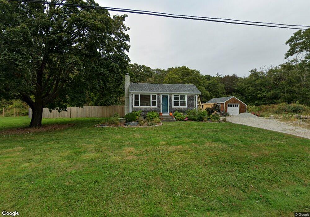
53 William Sisson Rd Little Compton, RI 02837
Estimated Value: $216,000 - $676,000
2
Beds
1
Bath
864
Sq Ft
$568/Sq Ft
Est. Value
About This Home
This home is located at 53 William Sisson Rd, Little Compton, RI 02837 and is currently estimated at $491,169, approximately $568 per square foot. 53 William Sisson Rd is a home located in Newport County with nearby schools including Wilbur & McMahon School.
Ownership History
Date
Name
Owned For
Owner Type
Purchase Details
Closed on
Oct 8, 2025
Sold by
Christine Hudson Lt and Hudson
Bought by
Camara Michael A
Current Estimated Value
Purchase Details
Closed on
Oct 6, 2025
Sold by
Kathleen A Chase Lt and Chase
Bought by
Camara Michael A
Purchase Details
Closed on
Nov 22, 2011
Sold by
Elkinton Christine H
Bought by
Chrisitne Hudson Lt and Camara
Create a Home Valuation Report for This Property
The Home Valuation Report is an in-depth analysis detailing your home's value as well as a comparison with similar homes in the area
Home Values in the Area
Average Home Value in this Area
Purchase History
| Date | Buyer | Sale Price | Title Company |
|---|---|---|---|
| Camara Michael A | -- | -- | |
| Camara Michael A | $210,500 | -- | |
| Chrisitne Hudson Lt | -- | -- |
Source: Public Records
Mortgage History
| Date | Status | Borrower | Loan Amount |
|---|---|---|---|
| Previous Owner | Chrisitne Hudson Lt | $100,000 | |
| Previous Owner | Chrisitne Hudson Lt | $29,600 |
Source: Public Records
Tax History
| Year | Tax Paid | Tax Assessment Tax Assessment Total Assessment is a certain percentage of the fair market value that is determined by local assessors to be the total taxable value of land and additions on the property. | Land | Improvement |
|---|---|---|---|---|
| 2025 | $1,992 | $415,900 | $227,000 | $188,900 |
| 2024 | $1,749 | $344,300 | $179,400 | $164,900 |
| 2023 | $1,708 | $344,300 | $179,400 | $164,900 |
| 2022 | $1,687 | $344,300 | $179,400 | $164,900 |
| 2021 | $1,710 | $283,100 | $156,000 | $127,100 |
| 2020 | $1,696 | $283,100 | $156,000 | $127,100 |
| 2019 | $1,679 | $283,100 | $156,000 | $127,100 |
| 2018 | $1,660 | $278,600 | $156,000 | $122,600 |
| 2016 | $1,580 | $278,600 | $156,000 | $122,600 |
| 2015 | $1,519 | $264,200 | $141,600 | $122,600 |
| 2014 | $1,490 | $264,200 | $141,600 | $122,600 |
Source: Public Records
Map
Nearby Homes
- 128 Maple Ave
- 138 Willow Ave
- 141 S Of Commons Rd
- 89 S Shore Rd
- 0 Willow Ave
- 505 Long Hwy
- 30 Indian Rd
- 255 John Dyer Rd
- 49 Ocean Dr
- 141 Peckham Rd
- 245 John Dyer Rd
- 38 Old Bull Ln
- 140I Long Hwy
- 140 Long Hwy
- 180 W Main Rd
- 441 W Main Rd
- 116 Amy Hart Path
- 17 Amy Hart Path
- 1 Puddingstone Cir
- 17 Ferolbink Way
- 54 William Sisson Rd
- 19 William Sisson Rd
- 45 William Sisson Rd
- 46 William Sisson Rd
- 46 William Sisson Rd
- 56 William Sisson Rd
- 42 William Sisson Rd
- 48 William Sisson Rd
- 44B William Sisson Rd
- 44 William Sisson Rd
- 44 William Sisson Rd Unit B
- 36 William Sisson Rd
- 35 William Sisson Rd
- 24C Maple Ave
- 24B Maple Ave
- 46 Maple Ave
- 50 Maple Ave
- 40 Maple Ave
- 56 Maple Ave
- 56 Maple Ave
Your Personal Tour Guide
Ask me questions while you tour the home.