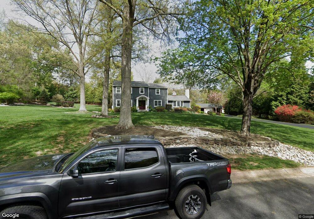
53 Windover Ln Doylestown, PA 18901
Estimated Value: $753,448 - $905,000
3
Beds
3
Baths
2,660
Sq Ft
$315/Sq Ft
Est. Value
About This Home
This home is located at 53 Windover Ln, Doylestown, PA 18901 and is currently estimated at $836,862, approximately $314 per square foot. 53 Windover Ln is a home located in Bucks County with nearby schools including Kutz Elementary School, Lenape Middle School, and Central Bucks High School-West.
Ownership History
Date
Name
Owned For
Owner Type
Purchase Details
Closed on
Dec 22, 2003
Sold by
Krysiak Joan D and Russell Joan D
Bought by
Fellin John P and Green Kevin Fitzgerald
Current Estimated Value
Home Financials for this Owner
Home Financials are based on the most recent Mortgage that was taken out on this home.
Original Mortgage
$300,000
Outstanding Balance
$139,014
Interest Rate
5.88%
Mortgage Type
Unknown
Estimated Equity
$697,848
Purchase Details
Closed on
Feb 13, 1985
Bought by
Krysiak Joan D
Create a Home Valuation Report for This Property
The Home Valuation Report is an in-depth analysis detailing your home's value as well as a comparison with similar homes in the area
Home Values in the Area
Average Home Value in this Area
Purchase History
| Date | Buyer | Sale Price | Title Company |
|---|---|---|---|
| Fellin John P | $420,000 | -- | |
| Krysiak Joan D | -- | -- |
Source: Public Records
Mortgage History
| Date | Status | Borrower | Loan Amount |
|---|---|---|---|
| Open | Fellin John P | $300,000 | |
| Closed | Fellin John P | $70,000 |
Source: Public Records
Tax History
| Year | Tax Paid | Tax Assessment Tax Assessment Total Assessment is a certain percentage of the fair market value that is determined by local assessors to be the total taxable value of land and additions on the property. | Land | Improvement |
|---|---|---|---|---|
| 2025 | $8,707 | $49,200 | $10,320 | $38,880 |
| 2024 | $8,707 | $49,200 | $10,320 | $38,880 |
| 2023 | $8,302 | $49,200 | $10,320 | $38,880 |
| 2022 | $8,210 | $49,200 | $10,320 | $38,880 |
| 2021 | $8,041 | $49,200 | $10,320 | $38,880 |
| 2020 | $8,004 | $49,200 | $10,320 | $38,880 |
| 2019 | $7,918 | $49,200 | $10,320 | $38,880 |
| 2018 | $7,893 | $49,200 | $10,320 | $38,880 |
| 2017 | $7,831 | $49,200 | $10,320 | $38,880 |
| 2016 | $7,782 | $49,200 | $10,320 | $38,880 |
| 2015 | -- | $49,200 | $10,320 | $38,880 |
| 2014 | -- | $49,200 | $10,320 | $38,880 |
Source: Public Records
Map
Nearby Homes
- 117 Windover Ln
- 2980 Yorkshire Rd
- 000 Cherry Ln
- 150 Watercrest Dr
- 152 Watercrest Dr
- 3775 Buckingham Dr
- 45 Springs Dr
- 3889 Robin Rd
- 223 Cherry Ln
- 34 Houk Rd
- 106 Saddle Dr
- 3795 Route 202
- 2372 Dorchester St W Unit W
- 2209 Swamp Rd
- 5 Belmont Square
- 9 Maple Ln
- 236 Green St
- 4245 Mechanicsville Rd
- 78 Tower Hill Rd
- 137 Pebble Woods Dri Pebble Woods Dr
Your Personal Tour Guide
Ask me questions while you tour the home.