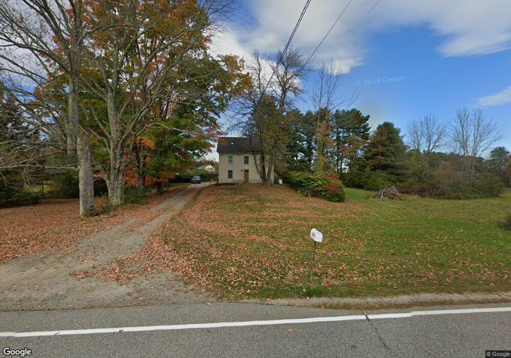
530 Boom Rd Saco, ME 04072
North Saco NeighborhoodEstimated Value: $455,836 - $544,000
2
Beds
2
Baths
1,770
Sq Ft
$286/Sq Ft
Est. Value
About This Home
This home is located at 530 Boom Rd, Saco, ME 04072 and is currently estimated at $506,209, approximately $285 per square foot. 530 Boom Rd is a home located in York County with nearby schools including C K Burns School and Saco Middle School.
Ownership History
Date
Name
Owned For
Owner Type
Purchase Details
Closed on
Oct 31, 2011
Sold by
Carlson Molly J
Bought by
Moreshead Costa
Current Estimated Value
Home Financials for this Owner
Home Financials are based on the most recent Mortgage that was taken out on this home.
Original Mortgage
$146,750
Outstanding Balance
$100,503
Interest Rate
4.11%
Mortgage Type
Purchase Money Mortgage
Estimated Equity
$405,706
Purchase Details
Closed on
Aug 14, 2009
Sold by
Randall Virginia S and Letourneau Virginia M
Bought by
Moreshead Cota and Carlson Molly
Home Financials for this Owner
Home Financials are based on the most recent Mortgage that was taken out on this home.
Original Mortgage
$147,000
Interest Rate
5.36%
Mortgage Type
Purchase Money Mortgage
Create a Home Valuation Report for This Property
The Home Valuation Report is an in-depth analysis detailing your home's value as well as a comparison with similar homes in the area
Home Values in the Area
Average Home Value in this Area
Purchase History
| Date | Buyer | Sale Price | Title Company |
|---|---|---|---|
| Moreshead Costa | $2,000 | -- | |
| Moreshead Cota | -- | -- |
Source: Public Records
Mortgage History
| Date | Status | Borrower | Loan Amount |
|---|---|---|---|
| Open | Moreshead Costa | $146,750 | |
| Previous Owner | Moreshead Cota | $147,000 | |
| Previous Owner | Moreshead Cota | $65,000 |
Source: Public Records
Tax History
| Year | Tax Paid | Tax Assessment Tax Assessment Total Assessment is a certain percentage of the fair market value that is determined by local assessors to be the total taxable value of land and additions on the property. | Land | Improvement |
|---|---|---|---|---|
| 2024 | $4,304 | $306,300 | $155,700 | $150,600 |
| 2023 | $4,518 | $306,300 | $155,700 | $150,600 |
| 2022 | $4,133 | $225,500 | $118,500 | $107,000 |
| 2021 | $3,933 | $208,300 | $107,200 | $101,100 |
| 2020 | $3,710 | $188,600 | $94,600 | $94,000 |
| 2019 | $3,655 | $188,600 | $94,600 | $94,000 |
| 2018 | $3,485 | $179,800 | $85,800 | $94,000 |
| 2017 | $3,372 | $174,000 | $78,800 | $95,200 |
| 2016 | $3,564 | $183,500 | $65,100 | $118,400 |
| 2015 | $3,475 | $180,800 | $63,800 | $117,000 |
| 2014 | $3,342 | $179,500 | $62,500 | $117,000 |
| 2013 | $3,335 | $179,500 | $62,500 | $117,000 |
Source: Public Records
Map
Nearby Homes
Your Personal Tour Guide
Ask me questions while you tour the home.