

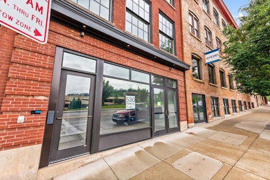
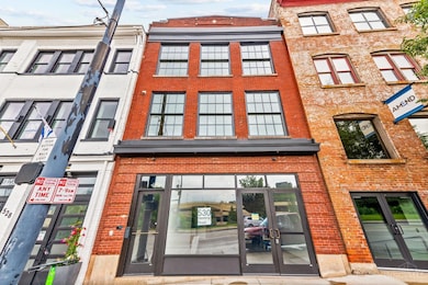
530 Reading Rd Cincinnati, OH 45202
Pendleton NeighborhoodEstimated payment $8,772/month
Highlights
- City View
- Deck
- 2 Car Attached Garage
- Walnut Hills High School Rated A+
- No HOA
- Forced Air Heating and Cooling System
About This Home
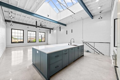
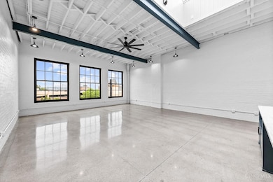
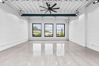
Newly renovated mixed-use building for sale in Pendleton across from the Casino! This is a great opportunity for a live/work space or used as an investment property. The top floor unit is the epitome of industrial chic w/polished concrete floors, 13ft ceilings, exposed beams & large south facing picture windows. Gourmet kitchen w/quartz countertops, oversized 10ft wide island, Thermador appliances & butler's pantry. Primary suite includes walk-in closet, glass shower & tub enclosure & double vanity. 2 skylights provide great natural light the top floor. There is a large roofdeck is great for entertaining & watching the fireworks! Attached private garage off the rear and elevator access to all floors. 2nd floor studio has in-unit laundry, polished concrete floors & plenty of closet space. This would make a great short-term rental! 1st floor retail whitebox space with 2 half baths and additional storage space in the rear. Easy access to OTR, CBD and highways. Tax abatement eligible.
Property Details
Home Type
- Multi-Family
Est. Annual Taxes
- $8,392
Year Built
- Built in 1911
Lot Details
- 2,396 Sq Ft Lot
- Lot Dimensions are 25x90
Parking
- 2 Car Attached Garage
- Rear-Facing Garage
- On-Street Parking
Home Design
- Brick Exterior Construction
- Slab Foundation
- Membrane Roofing
Interior Spaces
- 3-Story Property
- City Views
Outdoor Features
- Deck
Utilities
- Forced Air Heating and Cooling System
- Heating System Uses Gas
- Separate Meters
- Gas Available at Street
Community Details
- No Home Owners Association
- Pendleton Subdivision
Map
Home Values in the Area
Average Home Value in this Area
Tax History
| Year | Tax Paid | Tax Assessment Tax Assessment Total Assessment is a certain percentage of the fair market value that is determined by local assessors to be the total taxable value of land and additions on the property. | Land | Improvement |
|---|---|---|---|---|
| 2025 | $8,434 | $101,619 | $33,796 | $67,823 |
| 2024 | $8,378 | $101,619 | $33,796 | $67,823 |
| 2023 | $8,356 | $101,619 | $33,796 | $67,823 |
| 2022 | $10,119 | $111,563 | $56,119 | $55,444 |
| 2021 | $9,939 | $111,563 | $56,119 | $55,444 |
| 2020 | $9,950 | $111,563 | $56,119 | $55,444 |
| 2019 | $8,620 | $89,251 | $44,895 | $44,356 |
| 2018 | $8,625 | $89,251 | $44,895 | $44,356 |
| 2017 | $8,353 | $89,251 | $44,895 | $44,356 |
| 2016 | $1,550 | $16,139 | $10,518 | $5,621 |
| 2015 | $1,424 | $16,139 | $10,518 | $5,621 |
| 2014 | $1,429 | $16,139 | $10,518 | $5,621 |
| 2013 | $1,477 | $16,639 | $10,843 | $5,796 |
Property History
| Date | Event | Price | List to Sale | Price per Sq Ft |
|---|---|---|---|---|
| 01/20/2026 01/20/26 | Pending | -- | -- | -- |
| 11/17/2025 11/17/25 | Price Changed | $1,499,000 | -4.8% | -- |
| 06/04/2025 06/04/25 | For Sale | $1,575,000 | -- | -- |
Purchase History
| Date | Type | Sale Price | Title Company |
|---|---|---|---|
| Warranty Deed | $255,000 | -- | |
| Warranty Deed | $25,100 | -- |
Mortgage History
| Date | Status | Loan Amount | Loan Type |
|---|---|---|---|
| Open | $478,800 | Commercial |
Source: MLS of Greater Cincinnati (CincyMLS)
MLS Number: 1842620
APN: 075-0003-0160
Disclaimer: Certain information contained herein is derived from information provided by parties other than Homes.com. All information provided is deemed reliable, but is not guaranteed to be accurate and should be independently verified.
![]() The data relating to real estate for sale on this website comes in part from the Broker Reciprocity programs of the MLS of Greater Cincinnati, Inc.. Those listings held by brokerage firms other than Ten-X are marked with the Broker Reciprocity logo and house icon. The properties displayed may not be all of the properties available through Broker Reciprocity.
The data relating to real estate for sale on this website comes in part from the Broker Reciprocity programs of the MLS of Greater Cincinnati, Inc.. Those listings held by brokerage firms other than Ten-X are marked with the Broker Reciprocity logo and house icon. The properties displayed may not be all of the properties available through Broker Reciprocity.
IDX information is provided exclusively for personal, non-commercial use, and may not be used for any purpose other than to identify prospective properties consumers may be interested in purchasing.
Information is deemed reliable but not guaranteed.
Ten-X does not display the entire Cincinnati MLS Broker Reciprocity™ database on this web site. The listings of some real estate brokerage firms have been excluded.
Copyright 2026, MLS of Greater Cincinnati, Inc. All rights reserved

Ask me questions while you tour the home.