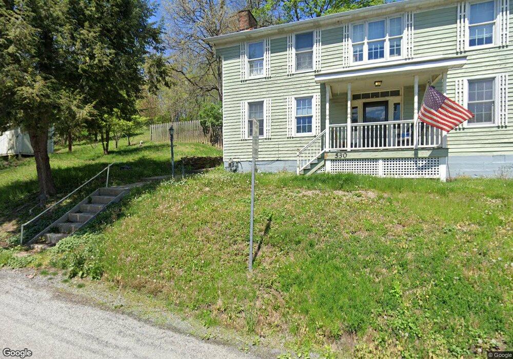
530 Ww Railroad Rd Sycamore, PA 15364
Estimated Value: $169,000 - $452,635
3
Beds
2
Baths
2,456
Sq Ft
$130/Sq Ft
Est. Value
About This Home
This home is located at 530 Ww Railroad Rd, Sycamore, PA 15364 and is currently estimated at $319,409, approximately $130 per square foot. 530 Ww Railroad Rd is a home located in Greene County with nearby schools including Waynesburg Central Elementary School, Miller Middle School, and Waynesburg Central High School.
Ownership History
Date
Name
Owned For
Owner Type
Purchase Details
Closed on
Mar 3, 2021
Sold by
Neely Merlin
Bought by
Three Rivers Royalty Llc
Current Estimated Value
Purchase Details
Closed on
Oct 5, 2020
Sold by
Trozzi Robert J and Trozzi Carolyn S
Bought by
Consol Pennsylvania Coal Company Llc
Purchase Details
Closed on
Sep 15, 2020
Sold by
Trozzi Robert J and Trozzi Carolyn S
Bought by
Trozzi Robert J and Trozzi Carolyn S
Purchase Details
Closed on
Apr 12, 2011
Sold by
Wolfe Gary W and Wolfe Joyce R
Bought by
Trozzi Robert J
Home Financials for this Owner
Home Financials are based on the most recent Mortgage that was taken out on this home.
Original Mortgage
$153,000
Interest Rate
4.82%
Mortgage Type
New Conventional
Create a Home Valuation Report for This Property
The Home Valuation Report is an in-depth analysis detailing your home's value as well as a comparison with similar homes in the area
Home Values in the Area
Average Home Value in this Area
Purchase History
| Date | Buyer | Sale Price | Title Company |
|---|---|---|---|
| Three Rivers Royalty Llc | -- | None Listed On Document | |
| Consol Pennsylvania Coal Company Llc | $325,000 | None Available | |
| Trozzi Robert J | -- | None Available | |
| Trozzi Robert J | -- | None Available |
Source: Public Records
Mortgage History
| Date | Status | Borrower | Loan Amount |
|---|---|---|---|
| Previous Owner | Trozzi Robert J | $153,000 |
Source: Public Records
Tax History Compared to Growth
Tax History
| Year | Tax Paid | Tax Assessment Tax Assessment Total Assessment is a certain percentage of the fair market value that is determined by local assessors to be the total taxable value of land and additions on the property. | Land | Improvement |
|---|---|---|---|---|
| 2025 | $2,554 | $61,120 | $9,400 | $51,720 |
| 2024 | $2,554 | $61,120 | $9,400 | $51,720 |
| 2023 | $2,554 | $61,120 | $9,400 | $51,720 |
| 2022 | $2,554 | $61,120 | $9,400 | $51,720 |
| 2021 | $2,554 | $61,120 | $9,400 | $51,720 |
| 2020 | $2,465 | $61,120 | $9,400 | $51,720 |
| 2019 | $2,465 | $61,120 | $9,400 | $51,720 |
| 2018 | $25 | $61,120 | $9,400 | $51,720 |
| 2017 | $2,359 | $61,120 | $9,400 | $51,720 |
| 2016 | -- | $61,120 | $9,400 | $51,720 |
| 2015 | -- | $61,120 | $9,400 | $51,720 |
| 2014 | -- | $61,120 | $9,400 | $51,720 |
| 2013 | -- | $61,120 | $9,400 | $51,720 |
Source: Public Records
Map
Nearby Homes
- 566 Pettit Rd
- 195 W W Railroad Rd
- 154 East Aly
- 131 and 140 Bowlby and Huffman St
- 595 N Richhill St
- 215 1st Ave
- 0 Arrowhead Rd Unit 1725469
- 160 S Bridge Rd
- 355 Park Ave
- 449 Race St
- 548 Race St
- 171 W Greene St
- 523 Braden St
- 154 S Richhill St
- 820 Sherman Ave
- 111 2nd St
- 197 N Liberty St
- 119 W Elm St
- 336 Fruit St
- 0 Lippencott Rd Unit 1718289