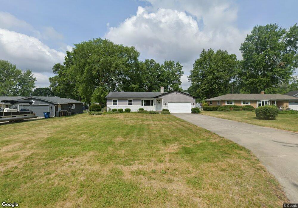
5301 Silvertown Dr Sylvania, OH 43560
Estimated Value: $207,000 - $252,338
3
Beds
3
Baths
1,288
Sq Ft
$178/Sq Ft
Est. Value
About This Home
This home is located at 5301 Silvertown Dr, Sylvania, OH 43560 and is currently estimated at $228,835, approximately $177 per square foot. 5301 Silvertown Dr is a home located in Lucas County with nearby schools including Hill View Elementary School, Sylvania Arbor Hills Junior High School, and Sylvania Northview High School.
Ownership History
Date
Name
Owned For
Owner Type
Purchase Details
Closed on
Jun 15, 2001
Sold by
Halm Thomas L & Margaret A Co Trustees
Bought by
Will Beverly M
Current Estimated Value
Home Financials for this Owner
Home Financials are based on the most recent Mortgage that was taken out on this home.
Original Mortgage
$123,900
Outstanding Balance
$47,093
Interest Rate
7.11%
Estimated Equity
$181,743
Purchase Details
Closed on
Apr 30, 1998
Sold by
Halm Thomas L and Halm Margaret A
Bought by
Halm Thomas L and Halm Margaret A
Create a Home Valuation Report for This Property
The Home Valuation Report is an in-depth analysis detailing your home's value as well as a comparison with similar homes in the area
Home Values in the Area
Average Home Value in this Area
Purchase History
| Date | Buyer | Sale Price | Title Company |
|---|---|---|---|
| Will Beverly M | $154,900 | Mta | |
| Halm Thomas L | -- | -- |
Source: Public Records
Mortgage History
| Date | Status | Borrower | Loan Amount |
|---|---|---|---|
| Open | Will Beverly M | $123,900 |
Source: Public Records
Tax History Compared to Growth
Tax History
| Year | Tax Paid | Tax Assessment Tax Assessment Total Assessment is a certain percentage of the fair market value that is determined by local assessors to be the total taxable value of land and additions on the property. | Land | Improvement |
|---|---|---|---|---|
| 2024 | $2,249 | $70,910 | $17,745 | $53,165 |
| 2023 | $3,646 | $49,875 | $14,455 | $35,420 |
| 2022 | $3,651 | $49,875 | $14,455 | $35,420 |
| 2021 | $3,747 | $49,875 | $14,455 | $35,420 |
| 2020 | $3,453 | $40,740 | $11,515 | $29,225 |
| 2019 | $3,321 | $40,740 | $11,515 | $29,225 |
| 2018 | $3,260 | $40,740 | $11,515 | $29,225 |
| 2017 | $5,257 | $38,955 | $15,190 | $23,765 |
| 2016 | $3,402 | $111,300 | $43,400 | $67,900 |
| 2015 | $3,201 | $111,300 | $43,400 | $67,900 |
| 2014 | $2,961 | $37,460 | $14,600 | $22,860 |
| 2013 | $2,961 | $37,460 | $14,600 | $22,860 |
Source: Public Records
Map
Nearby Homes
- 5202 Arbor Way
- 5131 Mcgregor Ln
- 5679 Monroe St Unit 108
- 5679 Monroe St Unit 214
- 5679 Monroe St Unit 218
- 5689 Corey Cove Unit 5689
- 5433 Whiteford Rd
- 5409 W Alexis Rd
- 5162 Kearsdale Rd
- 5 Riverhills Ln
- 5704 Webster Rd
- 5343 Fox Run
- 5224 Saddlecreek Rd
- 4824 Skelly Rd
- 6022 Roan Rd
- 6034 Roan Rd
- 6043 Roan Rd
- 5949 Roan Rd
- 6015 Roan Rd
- 6035 Roan Rd
- 5311 Silvertown Dr
- 5253 Silvertown Dr
- 5315 Silvertown Dr
- 5254 Lynnhaven Dr
- 5306 Lynnhaven Dr
- 5244 Lynnhaven Dr
- 5241 Silvertown Dr
- 5319 Silvertown Dr
- 5264 Silvertown Dr
- 5316 Lynnhaven Dr
- 5308 Silvertown Dr
- 5258 Silvertown Dr
- 5234 Lynnhaven Dr
- 5233 Silvertown Dr
- 5248 Silvertown Dr
- 5331 Silvertown Dr
- 5320 Silvertown Dr
- 5326 Lynnhaven Dr
- 5238 Arbor Way
- 5240 Silvertown Dr