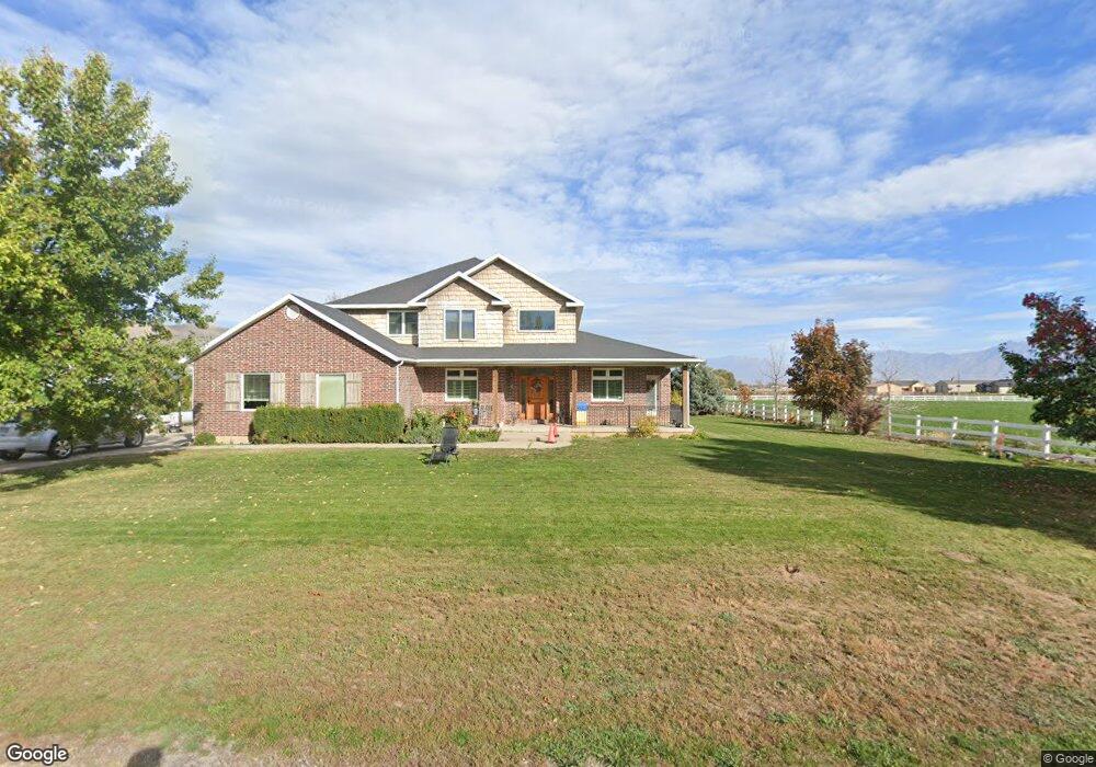
5302 W Rosewood Cir Unit W Payson, UT 84651
Estimated Value: $880,000 - $1,816,000
5
Beds
3
Baths
3,235
Sq Ft
$449/Sq Ft
Est. Value
About This Home
This home is located at 5302 W Rosewood Cir Unit W, Payson, UT 84651 and is currently estimated at $1,453,251, approximately $449 per square foot. 5302 W Rosewood Cir Unit W is a home located in Utah County with nearby schools including Taylor Elementary School, Mt. Nebo Junior High School, and Salem Junior High School.
Ownership History
Date
Name
Owned For
Owner Type
Purchase Details
Closed on
Aug 17, 2006
Sold by
Carter Shayne Max and Carter Trisha
Bought by
Carter Shayne M and Carter Trisha B
Current Estimated Value
Purchase Details
Closed on
May 31, 2005
Sold by
Rollins Rich L and Rollins Josephine B
Bought by
Carter Shayne Max and Carter Trisha
Purchase Details
Closed on
Jan 31, 2003
Sold by
Rollins Rich L
Bought by
Rollins Rich L and Rollins Josephine B
Home Financials for this Owner
Home Financials are based on the most recent Mortgage that was taken out on this home.
Original Mortgage
$300,000
Interest Rate
5.97%
Purchase Details
Closed on
Nov 30, 2001
Sold by
Larson Thomas Guy
Bought by
Rollins Rich L
Create a Home Valuation Report for This Property
The Home Valuation Report is an in-depth analysis detailing your home's value as well as a comparison with similar homes in the area
Home Values in the Area
Average Home Value in this Area
Purchase History
| Date | Buyer | Sale Price | Title Company |
|---|---|---|---|
| Carter Shayne M | -- | None Available | |
| Carter Shayne Max | -- | Title One | |
| Rollins Rich L | -- | Brighton Title Company | |
| Rollins Rich L | -- | Old Republic Title Company |
Source: Public Records
Mortgage History
| Date | Status | Borrower | Loan Amount |
|---|---|---|---|
| Previous Owner | Rollins Rich L | $300,000 |
Source: Public Records
Tax History Compared to Growth
Tax History
| Year | Tax Paid | Tax Assessment Tax Assessment Total Assessment is a certain percentage of the fair market value that is determined by local assessors to be the total taxable value of land and additions on the property. | Land | Improvement |
|---|---|---|---|---|
| 2025 | $5,114 | $494,820 | $458,700 | $718,000 |
| 2024 | $5,114 | $511,159 | $0 | $0 |
| 2023 | $5,359 | $536,148 | $0 | $0 |
| 2022 | $4,895 | $1,159,800 | $465,800 | $694,000 |
| 2021 | $4,409 | $863,400 | $329,600 | $533,800 |
| 2020 | $4,192 | $815,600 | $281,800 | $533,800 |
| 2019 | $4,131 | $768,300 | $232,600 | $535,700 |
| 2018 | $3,920 | $692,100 | $212,600 | $479,500 |
| 2017 | $3,864 | $315,055 | $0 | $0 |
| 2016 | $4,106 | $309,545 | $0 | $0 |
| 2015 | $3,959 | $295,910 | $0 | $0 |
| 2014 | $4,343 | $296,035 | $0 | $0 |
Source: Public Records
Map
Nearby Homes
- 11433 S 5600 W
- 11433 S 5600 West St
- 11363 S 5600 West St
- 5635 W 11300 S
- 5746 W 11300 S
- 2007 W 1150 S Unit 1041
- 11508 S 5825 W
- 1993 W 1150 S Unit 1038
- 1971 W 1150 S Unit 1034
- 1967 W 1150 S Unit 1033
- 1972 W 1150 S Unit 1027
- 1968 W 1150 S Unit 1028
- 841 N Dryland Cir Unit BALLAR
- 841 N Dryland Cir Unit DREXEL
- 841 N Dryland Cir Unit HILDAL
- 841 N Dryland Cir Unit WINDSR
- 841 N Dryland Cir Unit WAKEFI
- 841 N Dryland Cir Unit LUCAS
- 841 N Dryland Cir Unit AUBREY
- 841 N Dryland Cir Unit COLUMB
- 11519 S 5250 W Unit 1-G
- 11519 S 5250 W
- 5388 W Rosewood Cir
- 11553 S 5350 W
- 11578 S 5250 W
- 11519 S 5350 W
- 5335 W Rosewood Cir
- 11461 S 5250 W
- 5418 W Rosewood Cir Unit W
- 5418 W Rosewood Cir
- 11594 S 5350 W
- 11439 S 5250 W
- 5433 W Rosewood Cir
- 11368 S 5250 W
- 1327 S 2450 W
- 11322 S 5250 W
- 1269 S 2450 W
- 1245 S 2450 W
- 11461 S 5600 W
- 11252 S 5250 W