B
Seller's Agent in 2025
Brittany Cecil
Berkshire Hathaway HomeServices Yost & Little Realty
(336) 501-0161
97 Total Sales
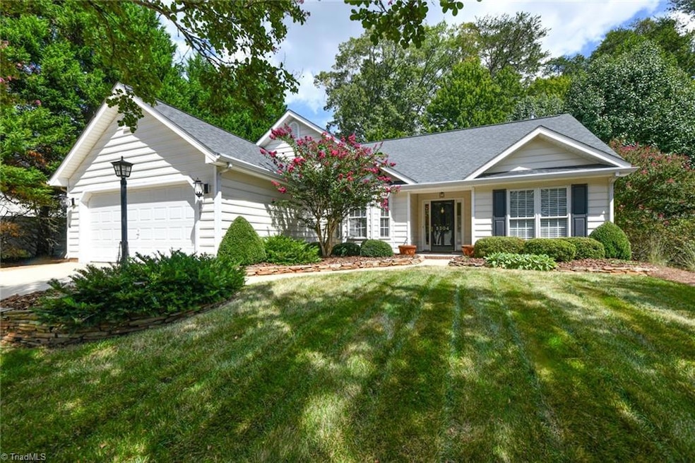


Absolutley IMMACULATE one level 3/2 home with 2 car garage in sought after Highland Grove. Pristine both inside & out, this charming rancher sits on one of the best lots in the neighborhood. The beautifully manicured & thoughfully landscaped lot backs to acres of wooded common area, providing an extra layer of tranquility and privacy. Incredible backyard outdoor space features expansive deck, stone outdoor fireplace, serene water feature, green space & more. Inside, you'll discover elegant hardwood floors, freshly painted interiors, new carpet in bdrms, a cozy great rm w/ gas logs & vaulted ceiling, as well as a chef's kitchen w/ granite counters that opens to the sunroom. Both bathrooms have been completely remodeled, including the luxurious primary en suite, which boasts a tiled walk-in shower, garden tub & dual sink vanity. Roof 2019. HVAC 2018. This Meticulously cared for home is primed for its new owners! Convenietly located mins from Bryan Blvd, shopping, restaurants & more!
Last Agent to Sell the Property
Berkshire Hathaway HomeServices Yost & Little Realty License #268425 Listed on: 09/04/2025

| Date | Type | Sale Price | Title Company |
|---|---|---|---|
| Warranty Deed | $380,000 | None Listed On Document | |
| Warranty Deed | $153,500 | -- |
| Date | Status | Loan Amount | Loan Type |
|---|---|---|---|
| Previous Owner | $130,310 | Purchase Money Mortgage |
| Date | Event | Price | List to Sale | Price per Sq Ft |
|---|---|---|---|---|
| 10/01/2025 10/01/25 | Sold | $380,000 | 0.0% | $228 / Sq Ft |
| 09/08/2025 09/08/25 | Pending | -- | -- | -- |
| 09/04/2025 09/04/25 | For Sale | $379,900 | -- | $228 / Sq Ft |
| Year | Tax Paid | Tax Assessment Tax Assessment Total Assessment is a certain percentage of the fair market value that is determined by local assessors to be the total taxable value of land and additions on the property. | Land | Improvement |
|---|---|---|---|---|
| 2025 | $3,444 | $245,500 | $55,000 | $190,500 |
| 2024 | $3,444 | $245,500 | $55,000 | $190,500 |
| 2023 | $3,444 | $245,500 | $55,000 | $190,500 |
| 2022 | $3,346 | $245,500 | $55,000 | $190,500 |
| 2021 | $2,459 | $176,500 | $42,000 | $134,500 |
| 2020 | $2,459 | $176,500 | $42,000 | $134,500 |
| 2019 | $2,459 | $176,500 | $0 | $0 |
| 2018 | $2,388 | $176,500 | $0 | $0 |
| 2017 | $2,406 | $176,500 | $0 | $0 |
| 2016 | $2,315 | $167,200 | $0 | $0 |
| 2015 | $2,328 | $167,200 | $0 | $0 |
| 2014 | $2,345 | $167,200 | $0 | $0 |
B
Seller's Agent in 2025
Brittany Cecil
Berkshire Hathaway HomeServices Yost & Little Realty
(336) 501-0161
97 Total Sales
Buyer's Agent in 2025
Laura Patrick
Fathom Realty
(336) 287-8159
10 Total Sales
Source: Triad MLS
MLS Number: 1194463
APN: 0070638
Disclaimer: Certain information contained herein is derived from information provided by parties other than Homes.com. All information provided is deemed reliable, but is not guaranteed to be accurate and should be independently verified.
![]() Copyright 2026 Triad MLS, Inc. All rights reserved. IDX information is provided exclusively for personal, non-commercial use, and may not be used for any purpose other than to identify prospective properties consumers may be interested in purchasing. Information is deemed reliable but not guaranteed. This site will be monitored for ‘scraping’ and any use of search facilities of data on the site other than by potential buyers/sellers is prohibited. All Sale data is for informational purposes only and is not an indication of a market analysis or appraisal. Properties marked with the Triad MLS, Inc. icon are provided courtesy of the Triad MLS, Inc.’s, Internet Data Exchange Database.
Copyright 2026 Triad MLS, Inc. All rights reserved. IDX information is provided exclusively for personal, non-commercial use, and may not be used for any purpose other than to identify prospective properties consumers may be interested in purchasing. Information is deemed reliable but not guaranteed. This site will be monitored for ‘scraping’ and any use of search facilities of data on the site other than by potential buyers/sellers is prohibited. All Sale data is for informational purposes only and is not an indication of a market analysis or appraisal. Properties marked with the Triad MLS, Inc. icon are provided courtesy of the Triad MLS, Inc.’s, Internet Data Exchange Database.
Ask me questions while you tour the home.