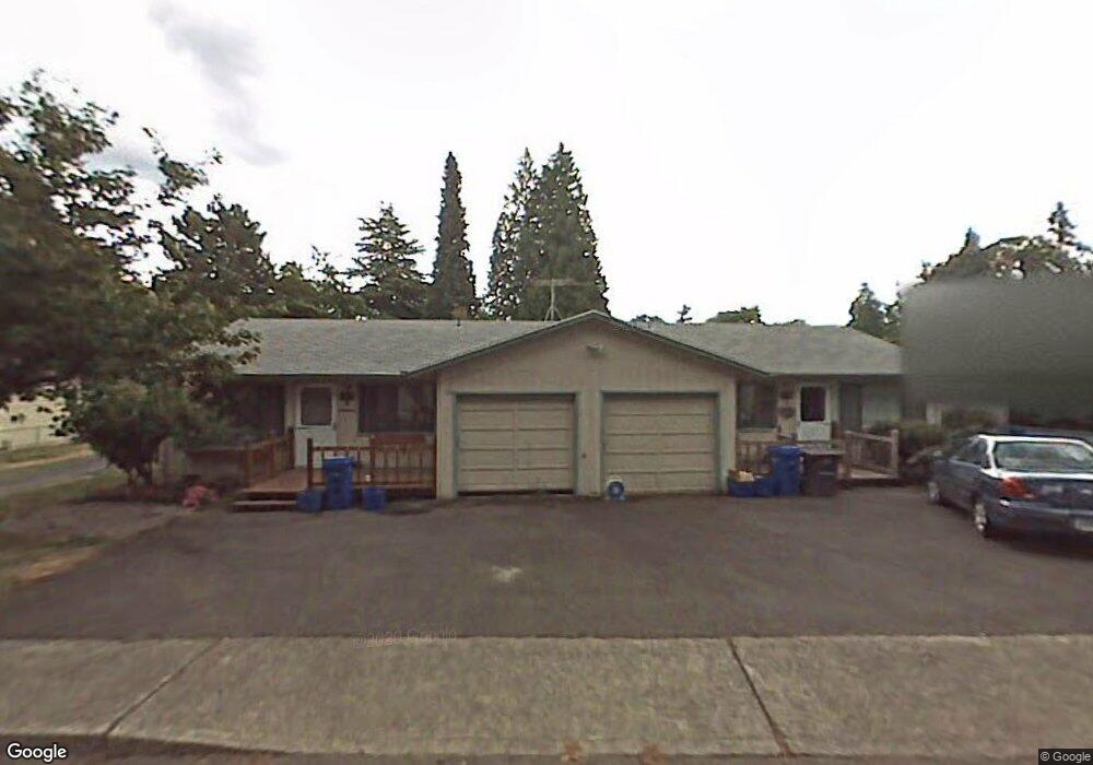
5304 Rinearson Rd Gladstone, OR 97027
Estimated Value: $508,852 - $566,000
4
Beds
2
Baths
1,808
Sq Ft
$296/Sq Ft
Est. Value
About This Home
This home is located at 5304 Rinearson Rd, Gladstone, OR 97027 and is currently estimated at $534,463, approximately $295 per square foot. 5304 Rinearson Rd is a home with nearby schools including Jennings Lodge Elementary School, Candy Lane Elementary School, and Gardiner Middle School.
Ownership History
Date
Name
Owned For
Owner Type
Purchase Details
Closed on
Oct 7, 2005
Sold by
King Richard L
Bought by
Lindvall David Mark
Current Estimated Value
Home Financials for this Owner
Home Financials are based on the most recent Mortgage that was taken out on this home.
Original Mortgage
$188,800
Interest Rate
5.7%
Mortgage Type
Commercial
Purchase Details
Closed on
Jul 28, 2005
Sold by
Dangremond Norman D and Dangremond Mary Lou
Bought by
King Richard L
Create a Home Valuation Report for This Property
The Home Valuation Report is an in-depth analysis detailing your home's value as well as a comparison with similar homes in the area
Home Values in the Area
Average Home Value in this Area
Purchase History
| Date | Buyer | Sale Price | Title Company |
|---|---|---|---|
| Lindvall David Mark | $236,000 | First American Title Insuran | |
| King Richard L | -- | -- |
Source: Public Records
Mortgage History
| Date | Status | Borrower | Loan Amount |
|---|---|---|---|
| Previous Owner | Lindvall David Mark | $188,800 |
Source: Public Records
Tax History
| Year | Tax Paid | Tax Assessment Tax Assessment Total Assessment is a certain percentage of the fair market value that is determined by local assessors to be the total taxable value of land and additions on the property. | Land | Improvement |
|---|---|---|---|---|
| 2025 | $4,692 | $255,682 | -- | -- |
| 2024 | $4,248 | $248,235 | -- | -- |
| 2023 | $4,248 | $241,005 | $0 | $0 |
| 2022 | $4,021 | $233,986 | $0 | $0 |
| 2021 | $3,858 | $227,171 | $0 | $0 |
| 2020 | $3,745 | $220,555 | $0 | $0 |
| 2019 | $3,664 | $214,132 | $0 | $0 |
| 2018 | $3,480 | $207,895 | $0 | $0 |
| 2017 | $3,388 | $201,840 | $0 | $0 |
| 2016 | $3,313 | $195,961 | $0 | $0 |
Source: Public Records
Map
Nearby Homes
- 19643 SE Jay St
- 19319 SE River Rd
- 19503 SE Kay St
- 5085 SE Britton Ave
- 19605 River Rd Unit 104
- 441 W Gloucester St
- 445 W Exeter St
- 19697 SE Cottonwood St
- 330 W Dartmouth St
- 390 W Arlington St
- 19333 SE River Drive Ct
- 115 E Jersey St
- 117 E Jersey St
- 119 E Jersey St
- 140 Nelson Ln
- 18418 SE Blanton St
- 18515 SE River Rd
- 5325 SE Hull Ave
- 18303 Portland Ave
- 18605 Sunlite Ct
- 5222 Rinearson Rd
- 5210 Rinearson Rd
- 5210 Rinearson Rd
- 5302 Rinearson Rd
- 5306 Rinearson Rd
- 5306 Rinearson Rd
- 5420 Rinearson Rd
- 5308 Rinearson Rd
- 19525 River Rd
- 5410 Rinearson Rd
- 5430 Rinearson Rd
- 19415 SE River Rd
- 5203 SE Rinearson Rd
- 5211 SE Rinearson Rd
- 19407 SE River Rd
- 19651 SE Jay St
- 19659 SE Jay St
- 19686 SE Jay St
- 5202 Rinearson Rd
- 19684 SE Jay St
Your Personal Tour Guide
Ask me questions while you tour the home.