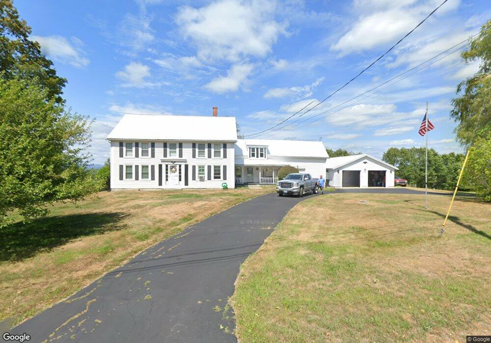
531 Range E Rd Limerick, ME 04048
Estimated Value: $350,000 - $569,378
Studio
--
Bath
840
Sq Ft
$569/Sq Ft
Est. Value
About This Home
This home is located at 531 Range E Rd, Limerick, ME 04048 and is currently estimated at $477,793, approximately $568 per square foot. 531 Range E Rd is a home located in York County with nearby schools including Massabesic High School.
Ownership History
Date
Name
Owned For
Owner Type
Purchase Details
Closed on
Oct 8, 2025
Sold by
Ricker Walter T
Bought by
Ricker Walter T
Current Estimated Value
Purchase Details
Closed on
Nov 2, 2023
Sold by
Ricker Walter T
Bought by
Patriot Place Prop Llc
Purchase Details
Closed on
Aug 2, 2023
Sold by
Ricker Walter T
Bought by
Tobias Wendy and Tobias Thomas
Purchase Details
Closed on
Feb 2, 2023
Sold by
Hayes Davelyn H and Wyman Holly H
Bought by
Ricker Walter T and Langford Diana G
Purchase Details
Closed on
Sep 27, 2016
Sold by
Thurland-Ricker W
Bought by
Ricker Walter T
Purchase Details
Closed on
Aug 29, 2013
Sold by
Ricker Walter T
Bought by
Moulton Wayne M and Moulton Karen M
Create a Home Valuation Report for This Property
The Home Valuation Report is an in-depth analysis detailing your home's value as well as a comparison with similar homes in the area
Home Values in the Area
Average Home Value in this Area
Purchase History
| Date | Buyer | Sale Price | Title Company |
|---|---|---|---|
| Ricker Walter T | -- | -- | |
| Patriot Place Prop Llc | $75,000 | None Available | |
| Patriot Place Prop Llc | $75,000 | None Available | |
| Tobias Wendy | $68,000 | None Available | |
| Tobias Wendy | $68,000 | None Available | |
| Ricker Walter T | $35,000 | None Available | |
| Ricker Walter T | -- | -- | |
| Moulton Wayne M | -- | -- | |
| Moulton Wayne M | -- | -- | |
| Ricker Walter T | -- | -- | |
| Moulton Wayne M | -- | -- |
Source: Public Records
Tax History
| Year | Tax Paid | Tax Assessment Tax Assessment Total Assessment is a certain percentage of the fair market value that is determined by local assessors to be the total taxable value of land and additions on the property. | Land | Improvement |
|---|---|---|---|---|
| 2025 | $4,866 | $512,263 | $170,730 | $341,533 |
| 2024 | $5,028 | $529,243 | $187,710 | $341,533 |
| 2023 | $3,670 | $241,424 | $79,280 | $162,144 |
| 2022 | $3,428 | $241,424 | $79,280 | $162,144 |
| 2021 | $3,206 | $193,139 | $63,424 | $129,715 |
| 2020 | $3,167 | $193,139 | $63,424 | $129,715 |
| 2019 | $3,042 | $193,139 | $63,424 | $129,715 |
| 2018 | $3,119 | $193,139 | $63,424 | $129,715 |
| 2017 | $3,042 | $193,139 | $63,424 | $129,715 |
| 2016 | $2,907 | $193,139 | $63,424 | $129,715 |
| 2015 | $2,820 | $193,139 | $63,424 | $129,715 |
| 2014 | $2,733 | $193,139 | $63,424 | $129,715 |
Source: Public Records
Map
Nearby Homes
- 451 Range E Rd
- 515 Range East Rd
- 545 Foss Rd
- 0 Stone Hill Rd
- 0 Mowry 0 Row Mowry Ln
- 590 Newfield Rd
- 5 Wescott St
- 0 Quarry Rd
- TBD Sokokis Trail & Beaver Brook Rd
- TBB Sokokis Trail & Beaver Brook Rd
- 24 Emery Corner Rd
- 4 Deer Crossing Rd
- 50 Island Rd
- LOT# 8 Business Park Rd
- Lot# 11 Business Park Rd
- 0 Island Rd Unit 1643509
- 220 Bond Spring Rd
- 240 Leisure Ln
- 25 Onamor Dr
- 148 Beaver Brook Rd
Your Personal Tour Guide
Ask me questions while you tour the home.