Estimated Value: $369,000 - $397,000
--
Bed
1
Bath
2,203
Sq Ft
$173/Sq Ft
Est. Value
About This Home
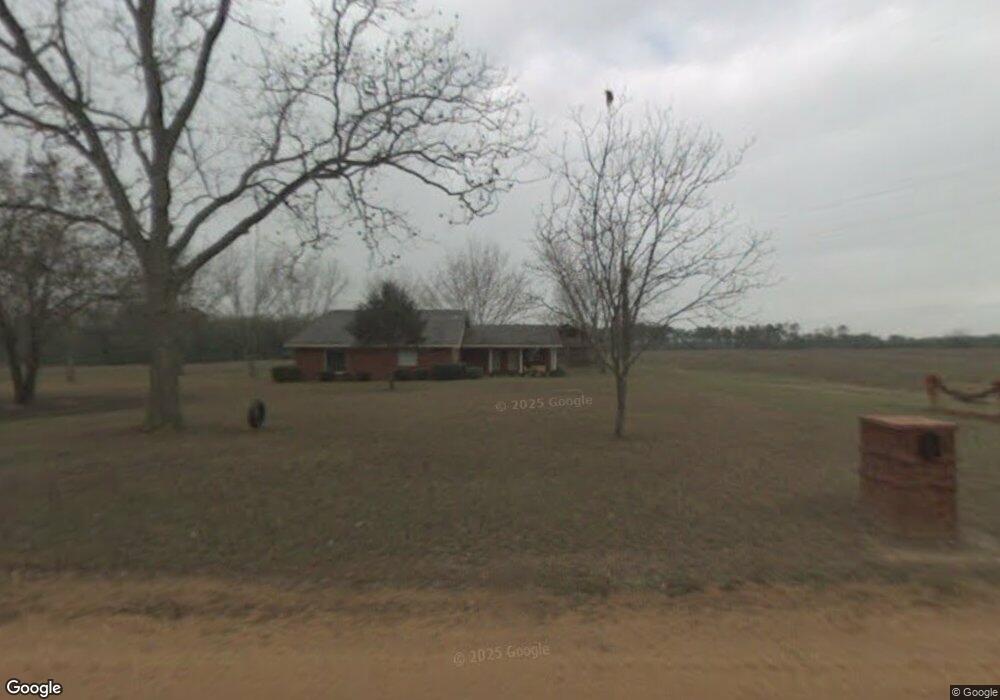
This home is located at 531 Richter Rd, Cairo, GA 39827 and is currently estimated at $380,518, approximately $172 per square foot. 531 Richter Rd is a home located in Grady County.
Ownership History
Date
Name
Owned For
Owner Type
Purchase Details
Closed on
Apr 18, 2024
Sold by
F & M Tyus Farm Llc
Bought by
Tyus David and Tyus Lori K
Current Estimated Value
Purchase Details
Closed on
Nov 10, 2017
Sold by
Lane Tyus F
Bought by
F
Purchase Details
Closed on
May 23, 2017
Bought by
Lane Tyus F and Gaines Anne T
Purchase Details
Closed on
Jun 21, 2012
Sold by
Tyus Lewis C
Bought by
Tyus Benjamin H
Purchase Details
Closed on
Jul 9, 1981
Bought by
Tyus Margaret E Estate
Create a Home Valuation Report for This Property
The Home Valuation Report is an in-depth analysis detailing your home's value as well as a comparison with similar homes in the area
Home Values in the Area
Average Home Value in this Area
Purchase History
| Date | Buyer | Sale Price | Title Company |
|---|---|---|---|
| Tyus David | $350,000 | -- | |
| F | -- | -- | |
| Lane Tyus F | -- | -- | |
| Tyus Benjamin H | -- | -- | |
| Tyus Margaret E Estate | -- | -- |
Source: Public Records
Tax History Compared to Growth
Tax History
| Year | Tax Paid | Tax Assessment Tax Assessment Total Assessment is a certain percentage of the fair market value that is determined by local assessors to be the total taxable value of land and additions on the property. | Land | Improvement |
|---|---|---|---|---|
| 2024 | $2,810 | $168,404 | $98,248 | $70,156 |
| 2023 | $1,972 | $95,626 | $52,150 | $43,476 |
| 2022 | $1,954 | $95,626 | $52,150 | $43,476 |
| 2021 | $1,943 | $95,626 | $52,150 | $43,476 |
| 2020 | $1,932 | $95,626 | $52,150 | $43,476 |
| 2019 | $1,916 | $95,626 | $52,150 | $43,476 |
| 2018 | $1,783 | $95,626 | $52,150 | $43,476 |
| 2017 | $1,632 | $95,626 | $52,150 | $43,476 |
| 2016 | $1,445 | $89,025 | $52,150 | $36,876 |
| 2015 | $1,416 | $89,025 | $52,150 | $36,876 |
| 2014 | $1,406 | $89,025 | $52,150 | $36,876 |
| 2013 | -- | $86,445 | $52,149 | $34,295 |
Source: Public Records
Map
Nearby Homes
- 1016 Richter Rd
- 105 Woodridge Ln
- 158 Woodridge Ln
- 414 Woodland Rd
- 264 Woodridge Ln
- 1210 Elkins Rd
- 00 State Route 188
- 0 State Route 188
- 3136 State Route 188
- 1725 Tract 2 Hwy 84w
- 1725 Tract #1 Hwy 84w
- 000 15th Ave Nw -- Tract 2
- 000 15th Ave Nw -- Tract 1
- 1420 Parallel Dr NW
- 1490 Magnolia Dr
- 1200 15th Ave NW
- 00 6th St NW
- 00 NW 9th Ave
- 2975 U S 84
- 698 12th Ave NW
- 532 Richter Rd
- 616 Richter Rd
- 181 Elkins Rd
- 630 Richter Rd
- 401 Richter Rd
- 648 Richter Rd
- 678 Richter Rd
- 384 Richter Rd
- 681 Richter Rd
- 694 Richter Rd
- 391 Richter Rd
- 710 Richter Rd
- 394 Richter Rd
- 360 Richter Rd
- 24.38ac Old Egg Rd
- 248 Old Egg Rd
- 592 Old Egg Rd
- 232 Old Egg Rd
- 469 Old Egg Rd
- 299 Old Egg Rd