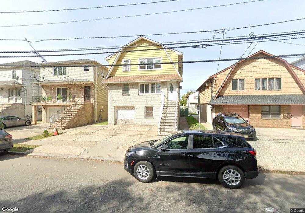
531 S 5th St Elizabethport, NJ 07206
Peters NeighborhoodEstimated Value: $664,212 - $815,000
7
Beds
3
Baths
2,400
Sq Ft
$303/Sq Ft
Est. Value
About This Home
This home is located at 531 S 5th St, Elizabethport, NJ 07206 and is currently estimated at $727,053, approximately $302 per square foot. 531 S 5th St is a home located in Union County with nearby schools including Number 15, Christopher Columbus Elementary School and Elizabeth High School.
Ownership History
Date
Name
Owned For
Owner Type
Purchase Details
Closed on
Nov 4, 1999
Sold by
Mouro Jose A and Mouro Rosa M
Bought by
Barahona Gustavo and Barahona Ana
Current Estimated Value
Home Financials for this Owner
Home Financials are based on the most recent Mortgage that was taken out on this home.
Original Mortgage
$194,700
Outstanding Balance
$59,122
Interest Rate
7.68%
Mortgage Type
Purchase Money Mortgage
Estimated Equity
$667,931
Create a Home Valuation Report for This Property
The Home Valuation Report is an in-depth analysis detailing your home's value as well as a comparison with similar homes in the area
Home Values in the Area
Average Home Value in this Area
Purchase History
| Date | Buyer | Sale Price | Title Company |
|---|---|---|---|
| Barahona Gustavo | $205,000 | Chicago Title Insurance Co |
Source: Public Records
Mortgage History
| Date | Status | Borrower | Loan Amount |
|---|---|---|---|
| Open | Barahona Gustavo | $194,700 |
Source: Public Records
Tax History Compared to Growth
Tax History
| Year | Tax Paid | Tax Assessment Tax Assessment Total Assessment is a certain percentage of the fair market value that is determined by local assessors to be the total taxable value of land and additions on the property. | Land | Improvement |
|---|---|---|---|---|
| 2025 | $10,867 | $564,800 | $170,500 | $394,300 |
| 2024 | $16,344 | $564,800 | $170,500 | $394,300 |
| 2023 | $16,344 | $52,000 | $9,000 | $43,000 |
| 2022 | $15,901 | $52,000 | $9,000 | $43,000 |
| 2021 | $15,573 | $52,000 | $9,000 | $43,000 |
| 2020 | $15,221 | $52,000 | $9,000 | $43,000 |
| 2019 | $14,988 | $52,000 | $9,000 | $43,000 |
| 2018 | $14,842 | $52,000 | $9,000 | $43,000 |
| 2017 | $14,428 | $52,000 | $9,000 | $43,000 |
| 2016 | $14,429 | $52,000 | $9,000 | $43,000 |
| 2015 | $13,571 | $52,000 | $9,000 | $43,000 |
| 2014 | $13,164 | $52,000 | $9,000 | $43,000 |
Source: Public Records
Map
Nearby Homes
- 429 Niles St Unit 431
- 325 Spencer St
- 619B Arnett St
- 315 S 5th St
- 624B Clarkson Ave
- 313 Loomis St
- 336 John St Unit 340
- 234 Niles St
- 232 Niles St
- 316-318 John St
- 433 3rd Ave
- 227 Palmer St
- 220 Palmer St
- 534-536 Maple Ave
- 221 Palmer St
- 230 Christine St Unit 32
- 566 2nd Ave
- 328 High St
- 437 Maple Ave
- 31 Spencer St
- 527 S 5th St
- 533 S 5th St Unit 535
- 535 S Pt 5th St
- 523-525 S 5th St
- 523 S 5th St Unit 525
- 526-528 Pt 526-528 Spencer St St
- 526 Spencer St Unit 528
- 532 Spencer St
- 530 Spencer St
- 521 S 5th St Unit 523
- 520 Spencer St Unit 522
- 534 Spencer St Unit 536
- 517 S 5th St Unit 519
- 516 Spencer St Unit 518
- 515 S 5th St Unit 517
- 515-517 S 5th St
- 512 Spencer St Unit 514
- 515-517 Spencer
- 508 Spencer St Unit 510
- 525 Spencer St