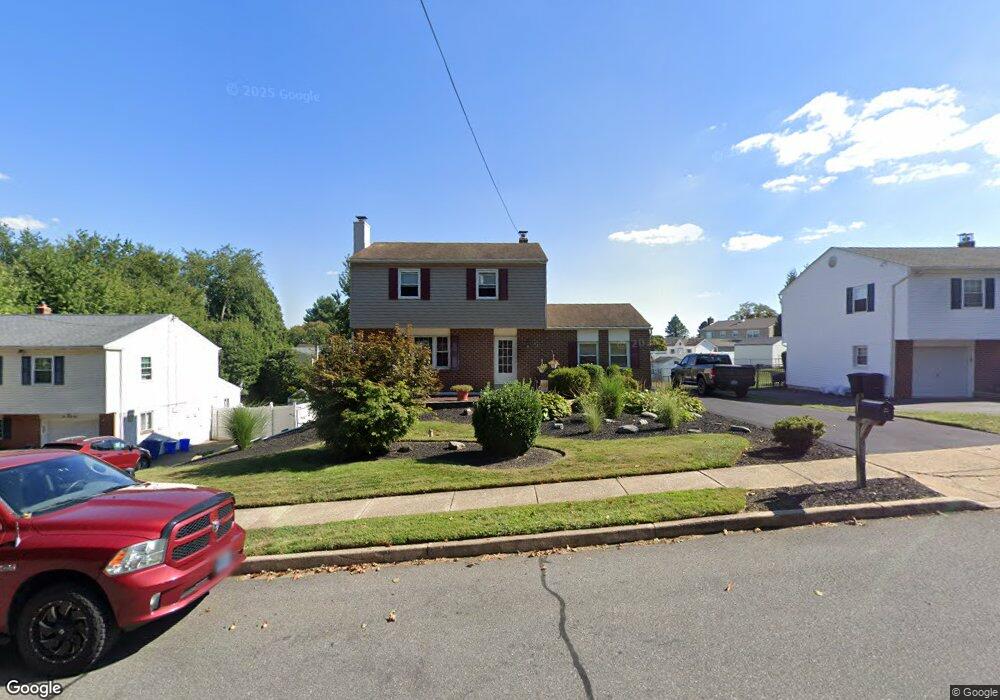
531 Weir Rd Aston, PA 19014
Estimated Value: $440,000 - $459,000
3
Beds
2
Baths
1,725
Sq Ft
$262/Sq Ft
Est. Value
About This Home
This home is located at 531 Weir Rd, Aston, PA 19014 and is currently estimated at $452,065, approximately $262 per square foot. 531 Weir Rd is a home located in Delaware County with nearby schools including Chichester Senior High School and Chester Charter School for the Arts.
Ownership History
Date
Name
Owned For
Owner Type
Purchase Details
Closed on
Jul 27, 2001
Sold by
Mcgee Edward P
Bought by
Davidson Steven and Davidson Nancy
Current Estimated Value
Home Financials for this Owner
Home Financials are based on the most recent Mortgage that was taken out on this home.
Original Mortgage
$166,250
Interest Rate
6.99%
Mortgage Type
Purchase Money Mortgage
Create a Home Valuation Report for This Property
The Home Valuation Report is an in-depth analysis detailing your home's value as well as a comparison with similar homes in the area
Home Values in the Area
Average Home Value in this Area
Purchase History
| Date | Buyer | Sale Price | Title Company |
|---|---|---|---|
| Davidson Steven | $174,900 | Fidelity National Title Ins |
Source: Public Records
Mortgage History
| Date | Status | Borrower | Loan Amount |
|---|---|---|---|
| Previous Owner | Davidson Steven | $166,250 |
Source: Public Records
Tax History Compared to Growth
Tax History
| Year | Tax Paid | Tax Assessment Tax Assessment Total Assessment is a certain percentage of the fair market value that is determined by local assessors to be the total taxable value of land and additions on the property. | Land | Improvement |
|---|---|---|---|---|
| 2025 | $7,374 | $284,160 | $77,490 | $206,670 |
| 2024 | $7,374 | $284,160 | $77,490 | $206,670 |
| 2023 | $7,043 | $284,160 | $77,490 | $206,670 |
| 2022 | $6,792 | $284,160 | $77,490 | $206,670 |
| 2021 | $10,481 | $284,160 | $77,490 | $206,670 |
| 2020 | $5,609 | $137,330 | $36,820 | $100,510 |
| 2019 | $5,501 | $137,330 | $36,820 | $100,510 |
| 2018 | $5,268 | $137,330 | $0 | $0 |
| 2017 | $5,156 | $137,330 | $0 | $0 |
| 2016 | $769 | $137,330 | $0 | $0 |
| 2015 | $769 | $137,330 | $0 | $0 |
| 2014 | $769 | $137,330 | $0 | $0 |
Source: Public Records
Map
Nearby Homes
- 2205 Weir Rd
- 734 Burdett Dr
- 711 Carole Dr
- 565 Applewood Ct
- 414 Dogwood Cir Unit 30
- 505 Schick Rd
- 4104 Kates Glen
- 4335 Somerset Ln
- 4701 Pennell Rd Unit J11
- 4701 Pennell Rd Unit H3
- 4224 Chatham Cir
- 921 Flora Ln
- 4130 Chichester Ave
- 887 Red Hill Rd
- 1418 Brayden Dr
- 4301 Aston Mills Rd
- 184 Fifth Ave
- 182 Fifth Ave
- 147 Third Ave
- 216 Park Dr
- 541 Weir Rd
- 551 Weir Rd
- 530 Longbotham Dr
- 761 Burdett Dr
- 240 Longbotham Dr
- 759 Burdett Dr
- 561 Weir Rd
- 550 Longbotham Dr
- 511 Weir Rd
- 3130 Highwoods Dr
- 560 Longbotham Dr
- 571 Weir Rd
- 757 Burdett Dr
- 570 Longbotham Dr
- 551 Longbotham Dr
- 541 Longbotham Dr
- 3110 Highwoods Dr
- 764 Burdett Dr
- 766 Burdett Dr
- 762 Burdett Dr