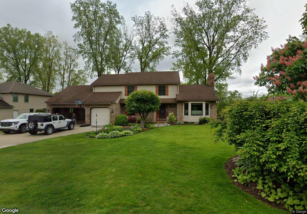
5310 Bronco Dr Clarkston, MI 48346
Estimated Value: $601,611 - $748,000
3
Beds
4
Baths
2,036
Sq Ft
$329/Sq Ft
Est. Value
About This Home
This home is located at 5310 Bronco Dr, Clarkston, MI 48346 and is currently estimated at $669,653, approximately $328 per square foot. 5310 Bronco Dr is a home located in Oakland County with nearby schools including Springfield Christian Academy, Our Lady Of The Lakes Catholic School, and Waterford Montessori Academy - Midland.
Ownership History
Date
Name
Owned For
Owner Type
Purchase Details
Closed on
Jan 23, 2025
Sold by
Martin Bradley C and Martin Mary H
Bought by
Martin Bradley C and Martin Mary H
Current Estimated Value
Purchase Details
Closed on
Apr 10, 2001
Sold by
Mark R Kraus Iii Tr
Bought by
Martin Bradley C
Home Financials for this Owner
Home Financials are based on the most recent Mortgage that was taken out on this home.
Original Mortgage
$269,900
Interest Rate
6.95%
Mortgage Type
Purchase Money Mortgage
Create a Home Valuation Report for This Property
The Home Valuation Report is an in-depth analysis detailing your home's value as well as a comparison with similar homes in the area
Home Values in the Area
Average Home Value in this Area
Purchase History
| Date | Buyer | Sale Price | Title Company |
|---|---|---|---|
| Martin Bradley C | -- | Land Title | |
| Martin Bradley C | -- | Land Title | |
| Martin Bradley C | $366,900 | -- |
Source: Public Records
Mortgage History
| Date | Status | Borrower | Loan Amount |
|---|---|---|---|
| Previous Owner | Martin Bradley C | $269,900 |
Source: Public Records
Tax History Compared to Growth
Tax History
| Year | Tax Paid | Tax Assessment Tax Assessment Total Assessment is a certain percentage of the fair market value that is determined by local assessors to be the total taxable value of land and additions on the property. | Land | Improvement |
|---|---|---|---|---|
| 2024 | $3,999 | $274,800 | $55,500 | $219,300 |
| 2023 | $5,391 | $249,700 | $50,500 | $199,200 |
| 2022 | $5,463 | $242,900 | $30,800 | $212,100 |
| 2021 | $5,473 | $233,200 | $30,800 | $202,400 |
| 2020 | $3,491 | $218,900 | $30,000 | $188,900 |
| 2018 | $5,185 | $195,800 | $29,800 | $166,000 |
| 2015 | -- | $165,900 | $0 | $0 |
| 2014 | -- | $146,400 | $0 | $0 |
| 2011 | -- | $189,300 | $0 | $0 |
Source: Public Records
Map
Nearby Homes
- 5021 Paula Ave
- 7314 Village Park Dr Unit 47
- 7509 Maple Ridge Dr
- 6832 Northcrest Way E Unit 31
- 4973 Parview Dr
- The Franklin II Plan at Park Ridge at Stonewood
- 7116 Oak Ridge Ct
- 7541 Maple Ridge Dr
- 7490 Andersonville Rd
- 6830 Dixie Hwy
- 9457 Dixie Hwy
- 7513 Maple Ridge Dr
- 7950 Clement Rd
- V/L Dixie Hwy
- 6788 Balmoral Terrace
- 6940 Stonewood Place Dr
- 6920 Stonewood Place Unit 42
- 6944 Stonewood Place Unit 36
- 4619 Curtis Ln
- 5025 Timberway Trail
- 5288 Bronco Dr
- 5332 Bronco Dr
- 5315 Bronco Dr
- 5270 Bronco Dr
- 5360 Bronco Dr
- 5347 Bronco Dr
- 7219 Mustang Dr
- 5250 Bronco Dr
- 5386 Bronco Dr
- 5261 Bronco Dr
- 7241 Mustang Dr
- 5228 Bronco Dr
- 5377 Bronco Dr
- 5247 Bronco Dr
- 7240 Mustang Dr
- 7033 Felix Dr
- 7259 Mustang Dr
- 7260 Mustang Dr
- 7023 Felix Dr
- 5210 Bronco Dr