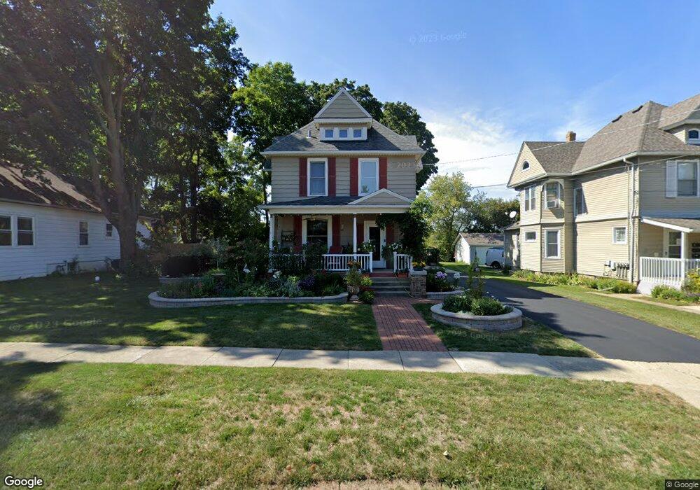
532 Austin Ave Woodstock, IL 60098
Estimated Value: $255,844 - $307,000
3
Beds
--
Bath
1,610
Sq Ft
$171/Sq Ft
Est. Value
About This Home
This home is located at 532 Austin Ave, Woodstock, IL 60098 and is currently estimated at $275,961, approximately $171 per square foot. 532 Austin Ave is a home located in McHenry County with nearby schools including Dean Street Elementary School, Creekside Middle School, and Woodstock High School.
Ownership History
Date
Name
Owned For
Owner Type
Purchase Details
Closed on
Sep 4, 2025
Sold by
Susan D Jarvis Revocable Trust and Jarvis Susan D
Bought by
Jarvis Susan
Current Estimated Value
Purchase Details
Closed on
Jan 14, 2025
Sold by
Ronald W Jarvis Revocable Trust and Jarvis Ronald W
Bought by
Susan D Jarvis Trust and Jarvis
Purchase Details
Closed on
Dec 3, 2020
Sold by
Jarvis Ronald W and Jarvis Susan D
Bought by
Susan D Jarvis Revocable Trust
Create a Home Valuation Report for This Property
The Home Valuation Report is an in-depth analysis detailing your home's value as well as a comparison with similar homes in the area
Home Values in the Area
Average Home Value in this Area
Purchase History
| Date | Buyer | Sale Price | Title Company |
|---|---|---|---|
| Jarvis Susan | -- | None Listed On Document | |
| Susan D Jarvis Trust | -- | None Listed On Document | |
| Susan D Jarvis Trust | -- | None Listed On Document | |
| Susan D Jarvis Revocable Trust | -- | None Listed On Document |
Source: Public Records
Tax History Compared to Growth
Tax History
| Year | Tax Paid | Tax Assessment Tax Assessment Total Assessment is a certain percentage of the fair market value that is determined by local assessors to be the total taxable value of land and additions on the property. | Land | Improvement |
|---|---|---|---|---|
| 2024 | $5,276 | $73,263 | $8,867 | $64,396 |
| 2023 | $4,672 | $66,254 | $8,019 | $58,235 |
| 2022 | $4,319 | $61,037 | $7,117 | $53,920 |
| 2021 | $4,037 | $57,028 | $6,650 | $50,378 |
| 2020 | $3,833 | $54,189 | $6,319 | $47,870 |
| 2019 | $4,217 | $51,727 | $6,032 | $45,695 |
| 2018 | $4,103 | $45,307 | $6,881 | $38,426 |
| 2017 | $3,993 | $42,642 | $6,476 | $36,166 |
| 2016 | $3,910 | $39,483 | $5,996 | $33,487 |
| 2013 | -- | $44,735 | $11,179 | $33,556 |
Source: Public Records
Map
Nearby Homes
- 125 Forest Ave
- 104 Stewart Ave
- 415 Dean St
- 421 W Kimball Ave
- 331 Chestnut St
- 908 Bunker St
- 3824 Riverwoods Dr
- 3902 Riverwoods Dr
- 1249 Prairie Ridge Trail
- 4022 Meadowridge Rd
- 3857 Riverwoods Dr
- 3917 Riverwoods Dr
- 3905 Riverwoods Dr
- 3839 Riverwoods Dr
- 3845 Riverwoods Dr
- 1288 Prairie Ridge Trail
- 1253 Prairie Ridge Trail
- 1245 Prairie Ridge Trail
- Brighton Plan at Clublands of Antioch - Horizon Series
- Meadowlark Plan at Clublands of Antioch - Horizon Series
- 526 Austin Ave Unit 2B
- 526 Austin Ave
- 526 Austin Ave Unit 2A
- 608 Austin Ave
- 520 Austin Ave
- 531 Putnam Ave
- 601 Putnam Ave
- 614 Austin Ave
- 605 Putnam Ave
- 512 Austin Ave
- 611 Putnam Ave
- 529 Austin Ave
- 603 Austin Ave
- 624 Austin Ave
- 525 Austin Ave
- 508 Austin Ave
- 411 Herrington Place
- 629 Putnam Ave
- 409 Herrington Place
- 630 Austin Ave