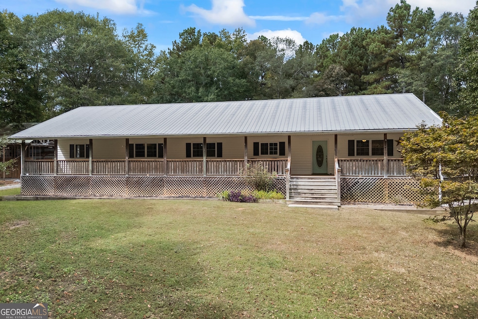
532 Davenport Rd Braselton, GA 30517
Estimated payment $3,331/month
Highlights
- Above Ground Pool
- RV or Boat Parking
- Ranch Style House
- West Jackson Elementary School Rated A-
- Private Lot
- Wood Flooring
About This Home
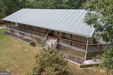
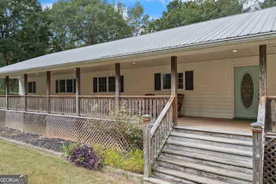
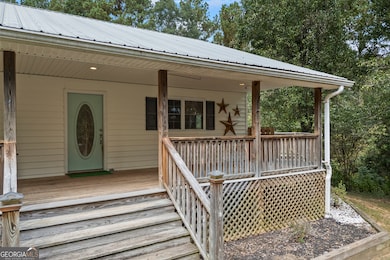
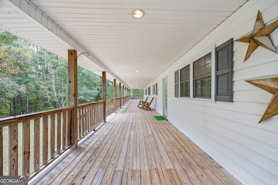
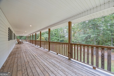
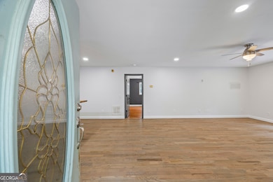
Welcome to your private retreat in Braselton - a charming 3-bedroom, 2-bath ranch perfectly set on 6.63 secluded acres. From the moment you arrive, you'll fall in love with the serenity that surrounds this home. The expansive rocking-chair front porch stretches the length of the house and gracefully wraps around to a side deck - the perfect spot for morning coffee, evening sunsets, or quiet gatherings under the stars. Step inside to a warm and inviting living room featuring french doors that open onto the deck, creating an effortless indoor-outdoor flow. The spacious kitchen offers granite countertops, newer cabinetry, and a stunning oversized butcher-block island - ideal for cooking, entertaining, or simply gathering. A separate dining room provides plenty of space for holidays and get-togethers. The primary suite is a true retreat, complete with French doors leading out to the deck and a beautifully updated ensuite featuring a large tiled shower and dual vanity. On the opposite side of the home, 3 additional bedrooms and a full bath provide comfort and flexibility for family, guests, or a home office. Outside, the possibilities are endless - enjoy a refreshing dip in the 24' above-ground pool complete with decking, the perfect spot for summer fun and relaxation. A detached 2-car carport offers convenience and storage, while a separate water, electric, and septic hookup makes this property truly exceptional for RV living or hosting extended guests. Located in the Jackson County school district, this property offers privacy, space, and a true sense of "home." With room to roam, relax, and recharge - this is where country living meets comfort. Welcome home.
Home Details
Home Type
- Single Family
Est. Annual Taxes
- $5,199
Year Built
- Built in 2000
Lot Details
- 6.63 Acre Lot
- Private Lot
Home Design
- Ranch Style House
- Traditional Architecture
- Metal Roof
- Vinyl Siding
Interior Spaces
- 2,560 Sq Ft Home
- Ceiling Fan
- Family Room
- Formal Dining Room
- Crawl Space
Kitchen
- Built-In Double Oven
- Cooktop
- Dishwasher
Flooring
- Wood
- Tile
Bedrooms and Bathrooms
- 3 Main Level Bedrooms
- 2 Full Bathrooms
- Double Vanity
- Bathtub Includes Tile Surround
Laundry
- Laundry in Mud Room
- Laundry Room
Parking
- Parking Shed
- RV or Boat Parking
Pool
- Above Ground Pool
Schools
- West Jackson Elementary And Middle School
- Jackson County High School
Utilities
- Central Heating and Cooling System
- Septic Tank
- High Speed Internet
- Phone Available
- Cable TV Available
Community Details
- No Home Owners Association
Map
Home Values in the Area
Average Home Value in this Area
Tax History
| Year | Tax Paid | Tax Assessment Tax Assessment Total Assessment is a certain percentage of the fair market value that is determined by local assessors to be the total taxable value of land and additions on the property. | Land | Improvement |
|---|---|---|---|---|
| 2024 | $5,151 | $192,880 | $84,320 | $108,560 |
| 2023 | $5,151 | $178,920 | $84,320 | $94,600 |
| 2022 | $3,098 | $102,720 | $28,640 | $74,080 |
| 2021 | $3,118 | $102,720 | $28,640 | $74,080 |
| 2020 | $2,994 | $90,760 | $28,640 | $62,120 |
| 2019 | $3,037 | $90,760 | $28,640 | $62,120 |
| 2018 | $3,056 | $90,160 | $28,640 | $61,520 |
| 2017 | $2,862 | $83,894 | $22,944 | $60,950 |
| 2016 | $2,874 | $83,894 | $22,944 | $60,950 |
| 2015 | $2,887 | $83,894 | $22,944 | $60,950 |
| 2014 | $2,799 | $83,041 | $22,944 | $60,098 |
| 2013 | -- | $83,041 | $22,943 | $60,097 |
Property History
| Date | Event | Price | List to Sale | Price per Sq Ft |
|---|---|---|---|---|
| 10/10/2025 10/10/25 | For Sale | $549,900 | -- | $215 / Sq Ft |
Purchase History
| Date | Type | Sale Price | Title Company |
|---|---|---|---|
| Deed | -- | -- | |
| Deed | -- | -- | |
| Deed | -- | -- |
Mortgage History
| Date | Status | Loan Amount | Loan Type |
|---|---|---|---|
| Open | $40,000 | New Conventional | |
| Open | $140,000 | New Conventional | |
| Closed | $40,000 | New Conventional | |
| Closed | $140,000 | New Conventional |
Source: Georgia MLS
MLS Number: 10622507
APN: 117-019F
Disclaimer: Certain information contained herein is derived from information provided by parties other than Homes.com. All information provided is deemed reliable, but is not guaranteed to be accurate and should be independently verified.
![]() The data relating to real estate for sale on this web site comes in part from the Broker Reciprocity Program of Georgia MLS. Real estate listings held by brokerage firms other than Redfin are marked with the Broker Reciprocity logo and detailed information about them includes the name of the listing brokers. Information deemed reliable but not guaranteed. Copyright 2025 Georgia MLS. All rights reserved.
The data relating to real estate for sale on this web site comes in part from the Broker Reciprocity Program of Georgia MLS. Real estate listings held by brokerage firms other than Redfin are marked with the Broker Reciprocity logo and detailed information about them includes the name of the listing brokers. Information deemed reliable but not guaranteed. Copyright 2025 Georgia MLS. All rights reserved.
- 0 Davenport Rd Unit 10583908
- 0 Davenport Rd Unit 16748330
- 1745 Liberty Park Dr
- 298 Fox Creek Dr
- 111 Horned Owl Ave
- 5068 Highway 53
- 21 Duck Rd
- 622 Pocket Rd
- 53 Ednaville Rd
- 880 Duck Rd
- 6647 Hwy 53
- 6647 Highway 53
- 0 Kinney Creek Ln Unit 10609320
- 193 Etsel Ln
- 1316 Sunny Valley Ln
- 1406 Sunny Valley Ln
- 1420 Sunny Valley Ln
- 1390 Sunny Valley Ln
- 236 Duck Rd
- 1464 Sunny Valley Ln
- 4429 Caney Fork Cir
- 701 Walnut Woods Dr
- 1145 Glenwyck Dr
- 206 Brookstone Trail
- 345 Hellen Valley Dr
- 273 Brookstone Trail Unit ID1254392P
- 4337 Caney Fork Cir
- 236 Brookstone Trail Unit ID1254384P
- 220 Brookstone Trail Unit ID1254412P
- 620 Walnut Woods Dr
- 1030 Glenwyck Dr
- 158 Port Way
- 40 Cava Terrace
- 9661 Davis St
- 284 Fox Creek Dr
- 125 Osprey Overlook Dr
- 115 Osprey Overlook Dr
- 49 Osprey Overlook Dr
