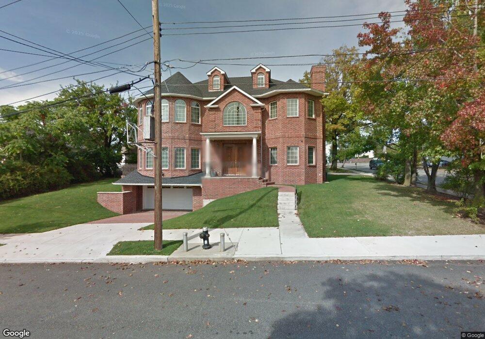
532 Foster Rd Staten Island, NY 10309
Woodrow NeighborhoodEstimated Value: $1,524,407 - $1,769,000
--
Bed
4
Baths
3,802
Sq Ft
$431/Sq Ft
Est. Value
About This Home
This home is located at 532 Foster Rd, Staten Island, NY 10309 and is currently estimated at $1,640,469, approximately $431 per square foot. 532 Foster Rd is a home located in Richmond County with nearby schools including Kathleen Grimm School For Leadership, P.S. 3 - The Margaret Gioiosa School, and Is 34 Tottenville.
Ownership History
Date
Name
Owned For
Owner Type
Purchase Details
Closed on
Nov 7, 2022
Sold by
Donati Jaime Prisco
Bought by
Donati John E and Donati Jaime Prisco
Current Estimated Value
Purchase Details
Closed on
May 26, 2010
Sold by
Donati Jaime Prisco
Bought by
Donati John E
Purchase Details
Closed on
Nov 23, 2009
Sold by
Big Js Realty Developers Inc
Bought by
Donati Jaime Prisco
Purchase Details
Closed on
Feb 15, 2000
Sold by
Chua Erdwin and Chua Julie
Bought by
Big Js Realty Developers Inc
Create a Home Valuation Report for This Property
The Home Valuation Report is an in-depth analysis detailing your home's value as well as a comparison with similar homes in the area
Home Values in the Area
Average Home Value in this Area
Purchase History
| Date | Buyer | Sale Price | Title Company |
|---|---|---|---|
| Donati John E | -- | -- | |
| Donati John E | -- | First Amer Title Ins Co Ny | |
| Donati Jaime Prisco | $96,000 | First Amer Title Ins Co Ny | |
| Big Js Realty Developers Inc | $132,500 | -- |
Source: Public Records
Tax History Compared to Growth
Tax History
| Year | Tax Paid | Tax Assessment Tax Assessment Total Assessment is a certain percentage of the fair market value that is determined by local assessors to be the total taxable value of land and additions on the property. | Land | Improvement |
|---|---|---|---|---|
| 2025 | $13,987 | $86,280 | $11,552 | $74,728 |
| 2024 | $13,987 | $88,140 | $10,761 | $77,379 |
| 2023 | $13,916 | $68,521 | $11,190 | $57,331 |
| 2022 | $12,905 | $77,640 | $13,620 | $64,020 |
| 2021 | $12,834 | $81,840 | $13,620 | $68,220 |
| 2020 | $12,908 | $77,940 | $13,620 | $64,320 |
| 2019 | $12,140 | $70,560 | $13,620 | $56,940 |
| 2018 | $11,342 | $57,101 | $13,349 | $43,752 |
| 2017 | $10,682 | $53,869 | $11,724 | $42,145 |
| 2016 | $9,850 | $50,820 | $13,620 | $37,200 |
| 2015 | $8,976 | $50,993 | $10,915 | $40,078 |
| 2014 | $8,976 | $48,360 | $11,340 | $37,020 |
Source: Public Records
Map
Nearby Homes
- 880 Sinclair Ave
- 973 Sheldon Ave
- 104 Wieland Ave
- 106 Wieland Ave
- 108 Wieland Ave
- 839 Sinclair Ave
- 960 Rensselaer Ave
- 142 Wieland Ave
- 1272 Woodrow Rd
- 980 Rensselaer Ave
- 859 Rathbun Ave
- 0 Woodrow Rd
- 816 Sinclair Ave
- 1030 Rensselaer Ave
- 265 Ramapo Ave
- 1046 Rensselaer Ave
- 727 Stafford Ave
- 1054 Rensselaer Ave
- 559 Alverson Ave
- 30 Alverson Loop
- 915 Sinclair Ave
- 540 Foster Rd
- 929 Sinclair Ave
- 546 Foster Rd
- 903 Sinclair Ave
- 866 Stafford Ave
- 912 Sinclair Ave
- 916 Sinclair Ave
- 533 Foster Rd
- 920 Sinclair Ave
- 545 Foster Rd
- 924 Sinclair Ave
- 935 Sinclair Ave
- 517 Foster Rd
- 899 Sinclair Ave
- 555 Foster Rd
- 515 Foster Rd
- 874 Stafford Ave
- 928 Sinclair Ave Unit 930
- 928-930 Sinclair Ave