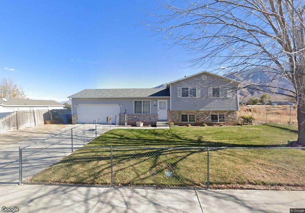
532 N 300 W Santaquin, UT 84655
Estimated Value: $437,174 - $470,000
3
Beds
2
Baths
1,048
Sq Ft
$427/Sq Ft
Est. Value
About This Home
This home is located at 532 N 300 W, Santaquin, UT 84655 and is currently estimated at $447,044, approximately $426 per square foot. 532 N 300 W is a home located in Utah County with nearby schools including Apple Valley Elementary, Payson Junior High School, and Payson High School.
Ownership History
Date
Name
Owned For
Owner Type
Purchase Details
Closed on
Nov 29, 2001
Sold by
Jensen Jay A
Bought by
Jensen Jay A and Jensen Raquel Lee
Current Estimated Value
Home Financials for this Owner
Home Financials are based on the most recent Mortgage that was taken out on this home.
Original Mortgage
$133,000
Outstanding Balance
$52,202
Interest Rate
6.63%
Estimated Equity
$394,842
Purchase Details
Closed on
Sep 25, 1998
Sold by
Salisbury Development L L C
Bought by
Jensen Jay A and Jensen Raquel Lee
Home Financials for this Owner
Home Financials are based on the most recent Mortgage that was taken out on this home.
Original Mortgage
$93,500
Interest Rate
6.88%
Create a Home Valuation Report for This Property
The Home Valuation Report is an in-depth analysis detailing your home's value as well as a comparison with similar homes in the area
Home Values in the Area
Average Home Value in this Area
Purchase History
| Date | Buyer | Sale Price | Title Company |
|---|---|---|---|
| Jensen Jay A | -- | Backman Stewart Title Servic | |
| Jensen Jay A | -- | Backman Stewart Title Servic | |
| Jensen Jay A | -- | -- |
Source: Public Records
Mortgage History
| Date | Status | Borrower | Loan Amount |
|---|---|---|---|
| Open | Jensen Jay A | $133,000 | |
| Closed | Jensen Jay A | $93,500 |
Source: Public Records
Tax History Compared to Growth
Tax History
| Year | Tax Paid | Tax Assessment Tax Assessment Total Assessment is a certain percentage of the fair market value that is determined by local assessors to be the total taxable value of land and additions on the property. | Land | Improvement |
|---|---|---|---|---|
| 2025 | $2,006 | $216,480 | $139,000 | $254,600 |
| 2024 | $2,006 | $199,760 | $0 | $0 |
| 2023 | $2,109 | $210,705 | $0 | $0 |
| 2022 | $2,003 | $206,360 | $0 | $0 |
| 2021 | $1,691 | $270,100 | $78,400 | $191,700 |
| 2020 | $1,620 | $250,800 | $68,200 | $182,600 |
| 2019 | $1,434 | $227,000 | $68,200 | $158,800 |
| 2018 | $1,309 | $197,600 | $59,500 | $138,100 |
| 2017 | $1,303 | $105,050 | $0 | $0 |
| 2016 | $1,186 | $93,720 | $0 | $0 |
| 2015 | $1,054 | $81,675 | $0 | $0 |
| 2014 | $966 | $74,745 | $0 | $0 |
Source: Public Records
Map
Nearby Homes
- 162 W 690 N
- 369 N 500 W Unit 3
- 600 N Center St
- 921 N 160 E
- 921 N 160 E Unit 12
- 931 N 160 E Unit 11
- 931 N 160 E
- 922 N 160 E Unit 20
- 932 N 160 E Unit 21
- 41 W 770 N
- Pendleton Plan at Silver Oaks
- 951 N 215 W
- 949 N 215 W
- 947 N 215 W
- 953 N 215 W
- 931 N 215 W
- 358 W 910 N
- 685 Empress St Unit 79
- 689 Empress St Unit 78
- 43 N 300 W