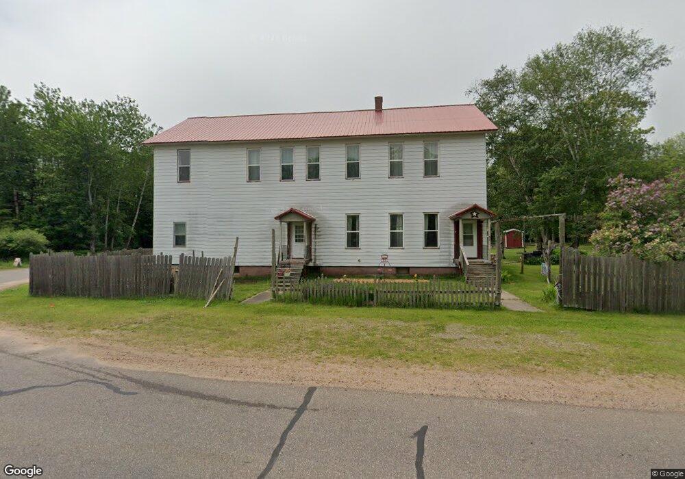
532 N Carlshend Rd Skandia, MI 49885
Estimated Value: $315,840 - $560,000
--
Bed
--
Bath
3,840
Sq Ft
$108/Sq Ft
Est. Value
About This Home
This home is located at 532 N Carlshend Rd, Skandia, MI 49885 and is currently estimated at $413,613, approximately $107 per square foot. 532 N Carlshend Rd is a home located in Marquette County with nearby schools including K.I. Sawyer Elementary School and Gwinn Middle/High School.
Ownership History
Date
Name
Owned For
Owner Type
Purchase Details
Closed on
Jan 27, 2021
Sold by
Newman Richard L and Newman Miriam A
Bought by
Johnson Eric and Johnson Hayley
Current Estimated Value
Home Financials for this Owner
Home Financials are based on the most recent Mortgage that was taken out on this home.
Original Mortgage
$237,000
Outstanding Balance
$211,860
Interest Rate
2.67%
Mortgage Type
New Conventional
Estimated Equity
$201,753
Purchase Details
Closed on
May 1, 1997
Bought by
Newman Richard and Newman Miriam
Create a Home Valuation Report for This Property
The Home Valuation Report is an in-depth analysis detailing your home's value as well as a comparison with similar homes in the area
Home Values in the Area
Average Home Value in this Area
Purchase History
| Date | Buyer | Sale Price | Title Company |
|---|---|---|---|
| Johnson Eric | $250,000 | -- | |
| Newman Richard | $56,000 | -- |
Source: Public Records
Mortgage History
| Date | Status | Borrower | Loan Amount |
|---|---|---|---|
| Open | Johnson Eric | $237,000 |
Source: Public Records
Tax History Compared to Growth
Tax History
| Year | Tax Paid | Tax Assessment Tax Assessment Total Assessment is a certain percentage of the fair market value that is determined by local assessors to be the total taxable value of land and additions on the property. | Land | Improvement |
|---|---|---|---|---|
| 2025 | $18 | $139,100 | $0 | $0 |
| 2024 | $18 | $133,500 | $0 | $0 |
| 2023 | $1,142 | $118,300 | $0 | $0 |
| 2022 | $4,613 | $71,900 | $0 | $0 |
| 2021 | $1,110 | $73,300 | $0 | $0 |
| 2020 | $1,094 | $71,900 | $0 | $0 |
| 2019 | $1,018 | $69,200 | $0 | $0 |
| 2018 | $992 | $66,600 | $0 | $0 |
| 2017 | $969 | $63,300 | $0 | $0 |
| 2016 | $968 | $59,350 | $0 | $0 |
| 2015 | -- | $59,350 | $0 | $0 |
| 2014 | -- | $58,950 | $0 | $0 |
| 2012 | -- | $60,350 | $0 | $0 |
Source: Public Records
Map
Nearby Homes
- 232 Winberg Rd
- TBD S Us41
- TBD N Sundell Rd
- TBD Carlshend Little Lake Rd
- V/L 20A Dukes Rd
- 320 Dukes Rd
- 0 Michigan 94
- 80 Acres Off Michigan 94
- 186 Abrahams Rd
- 1400 Setter Rd
- 40 Acres Maple Grove Rd
- 627 Michigan 94
- 105 Dalton Rd
- 2020 Cr456 Rd
- 40 Acres Dalton Rd
- 40 Acres Dalton Rd
- 1882 1st St
- 3749 U S 41
- 1681 E M35
- 1687 E M35
- 532 N Carlshend Rd
- 3759 County Road 456
- 3755 County Road 456
- 100 Valli Rd
- 3735 County Road 456
- 108 Valli Rd
- 521 N Carlshend Rd
- 521 N Carlshend Rd
- 521 N Carlshend Rd
- 512 N Carlshend Rd
- 3725 County Road 456
- 563 S Carlshend Rd
- 502 N Carlshend Rd
- 495 N Carlshend Rd
- 3709 County Road 456
- 134 Valli Rd
- 490 N Carlshend Rd
- 490 N Carlshend Rd
- 490 N Carlshend Rd
- 3703 County Road 456