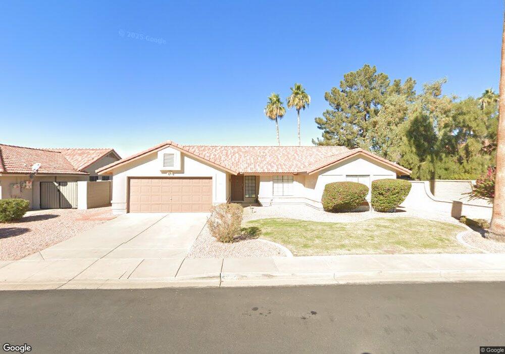
5320 E Enrose Cir Mesa, AZ 85205
Central Mesa East NeighborhoodEstimated Value: $428,185 - $504,000
Studio
3
Baths
1,759
Sq Ft
$275/Sq Ft
Est. Value
About This Home
This home is located at 5320 E Enrose Cir, Mesa, AZ 85205 and is currently estimated at $483,546, approximately $274 per square foot. 5320 E Enrose Cir is a home located in Maricopa County with nearby schools including Mendoza Elementary School, Franklin at Brimhall Elementary School, and Franklin West Elementary School.
Ownership History
Date
Name
Owned For
Owner Type
Purchase Details
Closed on
Apr 10, 2000
Sold by
Sharman Debra Ann and Mccord Tony
Bought by
Stump Harold and Beach Joanne
Current Estimated Value
Home Financials for this Owner
Home Financials are based on the most recent Mortgage that was taken out on this home.
Original Mortgage
$118,400
Outstanding Balance
$39,512
Interest Rate
7.87%
Mortgage Type
New Conventional
Estimated Equity
$444,034
Purchase Details
Closed on
Sep 2, 1999
Sold by
Sharman Leonard Sinclair and Sharman Bette Marie
Bought by
Sharman Debra Ann and Mccord Tony
Create a Home Valuation Report for This Property
The Home Valuation Report is an in-depth analysis detailing your home's value as well as a comparison with similar homes in the area
Home Values in the Area
Average Home Value in this Area
Purchase History
We collect this data history from publicly available records. To have your information removed, we recommend requesting removal directly through your county’s website.
| Date | Buyer | Sale Price | Title Company |
|---|---|---|---|
| Stump Harold | $148,000 | First American Title | |
| Sharman Debra Ann | -- | -- |
Source: Public Records
Mortgage History
We collect this data history from publicly available records. To have your information removed, we recommend requesting removal directly through your county’s website.
| Date | Status | Borrower | Loan Amount |
|---|---|---|---|
| Open | Stump Harold | $118,400 |
Source: Public Records
Tax History
| Year | Tax Paid | Tax Assessment Tax Assessment Total Assessment is a certain percentage of the fair market value that is determined by local assessors to be the total taxable value of land and additions on the property. | Land | Improvement |
|---|---|---|---|---|
| 2025 | $2,380 | $24,119 | -- | -- |
| 2024 | $2,387 | $22,971 | -- | -- |
| 2023 | $2,387 | $37,210 | $7,440 | $29,770 |
| 2022 | $2,337 | $28,030 | $5,600 | $22,430 |
| 2021 | $2,366 | $25,180 | $5,030 | $20,150 |
| 2020 | $2,335 | $23,480 | $4,690 | $18,790 |
| 2019 | $2,182 | $21,960 | $4,390 | $17,570 |
| 2018 | $2,094 | $21,070 | $4,210 | $16,860 |
| 2017 | $2,032 | $20,310 | $4,060 | $16,250 |
| 2016 | $1,994 | $20,230 | $4,040 | $16,190 |
| 2015 | $1,874 | $19,480 | $3,890 | $15,590 |
Source: Public Records
Map
Nearby Homes
- 1020 N Sinova
- 5410 E Dodge St
- 5207 E Dodge St
- 5422 E Dodge St
- 5136 E Evergreen St Unit 1006
- 5502 E Duncan St
- 5135 E Evergreen St Unit 1155
- 5135 E Evergreen St Unit 1253
- 5325 E Des Moines St
- 5446 E Dallas St
- 5131 E Dallas St
- 632 N Balboa Cir
- 5552 E Enrose St
- 5056 E Dallas St
- 1031 N Arroya
- 708 N 56th St
- 5018 E Downing St
- 5621 E Duncan St
- 5502 E Colby St
- 517 N 53rd Place
- 5326 E Enrose Cir
- 5312 E Enrose St
- 5304 E Enrose St
- 5336 E Enrose Cir
- 5327 E Enrose Cir
- 5317 E Enrose St
- 5335 E Enrose Cir
- 5254 E Enrose St
- 5344 E Enrose Cir
- 5309 E Enrose St
- 5338 E Ellis St
- 5301 E Enrose St
- 5343 E Enrose Cir
- 5246 E Enrose St
- 5323 E Ellis St
- 5352 E Enrose Cir
- 5261 E Enrose St
- 5331 E Ellis St
- 5346 E Ellis St
- 5238 E Enrose St
Your Personal Tour Guide
Ask me questions while you tour the home.