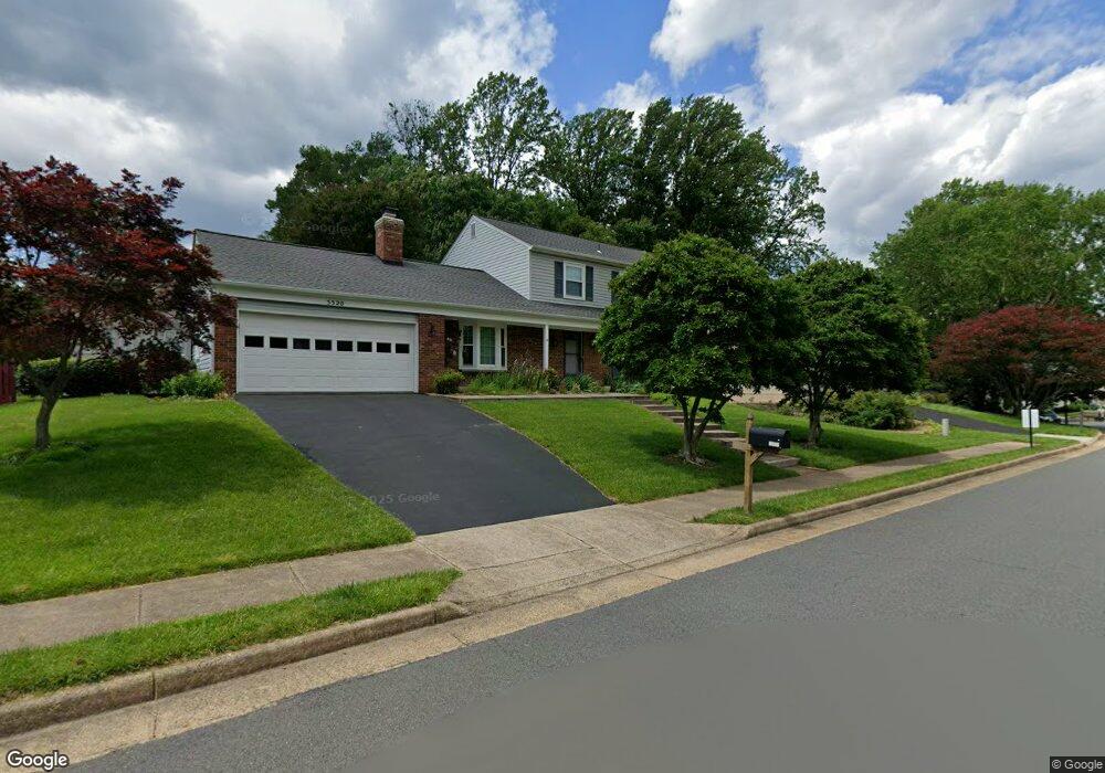
5320 Lindsay St Fairfax, VA 22032
Estimated Value: $874,000 - $1,018,000
4
Beds
3
Baths
2,220
Sq Ft
$420/Sq Ft
Est. Value
About This Home
This home is located at 5320 Lindsay St, Fairfax, VA 22032 and is currently estimated at $932,247, approximately $419 per square foot. 5320 Lindsay St is a home located in Fairfax County with nearby schools including Bonnie Brae Elementary School, James W Robinson, Jr. Secondary School, and Trinity Christian School.
Ownership History
Date
Name
Owned For
Owner Type
Purchase Details
Closed on
Nov 18, 1994
Sold by
Boling Gerald E
Bought by
Denley George T
Current Estimated Value
Home Financials for this Owner
Home Financials are based on the most recent Mortgage that was taken out on this home.
Original Mortgage
$100,000
Interest Rate
8.9%
Create a Home Valuation Report for This Property
The Home Valuation Report is an in-depth analysis detailing your home's value as well as a comparison with similar homes in the area
Home Values in the Area
Average Home Value in this Area
Purchase History
| Date | Buyer | Sale Price | Title Company |
|---|---|---|---|
| Denley George T | $229,450 | -- |
Source: Public Records
Mortgage History
| Date | Status | Borrower | Loan Amount |
|---|---|---|---|
| Closed | Denley George T | $100,000 |
Source: Public Records
Tax History Compared to Growth
Tax History
| Year | Tax Paid | Tax Assessment Tax Assessment Total Assessment is a certain percentage of the fair market value that is determined by local assessors to be the total taxable value of land and additions on the property. | Land | Improvement |
|---|---|---|---|---|
| 2025 | $8,965 | $814,330 | $296,000 | $518,330 |
| 2024 | $8,965 | $773,830 | $281,000 | $492,830 |
| 2023 | $8,614 | $763,320 | $281,000 | $482,320 |
| 2022 | $8,049 | $703,860 | $256,000 | $447,860 |
| 2021 | $7,587 | $646,490 | $236,000 | $410,490 |
| 2020 | $7,344 | $620,520 | $231,000 | $389,520 |
| 2019 | $7,226 | $610,520 | $221,000 | $389,520 |
| 2018 | $6,733 | $585,520 | $211,000 | $374,520 |
| 2017 | $6,798 | $585,520 | $211,000 | $374,520 |
| 2016 | $6,442 | $556,060 | $201,000 | $355,060 |
| 2015 | $6,206 | $556,060 | $201,000 | $355,060 |
| 2014 | $6,054 | $543,680 | $201,000 | $342,680 |
Source: Public Records
Map
Nearby Homes
- 0 Joshua Davis Ct
- 10919 Spurlock Ct
- 10708 Rippon Lodge Dr
- 10710 Almond St
- 5538 Shooters Hill Ln
- 11123 Popes Head Rd
- 11102 Fairfax Station Rd
- 5503 Fireside Ct
- 10402 Hollyoak Place
- 10412 Pearl St
- 5674 Oak Tanager Ct
- 10434 Calumet Grove Dr
- 5703 Oak Stake Ct
- 5602 Summer Oak Way
- 11433 Popes Head Rd
- 5900 Carters Oak Ct
- 5453 Cheshire Meadows Way
- 11317 Edenderry Dr
- 5515 Cheshire Meadows Way
- 10271 Braddock Rd
- 10902 Rippon Lodge Dr
- 5318 Lindsay St
- 5319 Lindsay St
- 10904 Rippon Lodge Dr
- 10901 Rippon Lodge Dr
- 10817 Rippon Lodge Dr
- 5316 Lindsay St
- 5317 Lindsay St
- 10903 Rippon Lodge Dr
- 10815 Rippon Lodge Dr
- 10814 Rippon Lodge Dr
- 5312 Lindsay St
- 10905 Rippon Lodge Dr
- 5307 Lindsay St
- 10906 Rippon Lodge Dr
- 5314 Lindsay St
- 5315 Lindsay St
- 10813 Rippon Lodge Dr
- 5399 Quincy Marr Dr
- 5397 Quincy Marr Dr