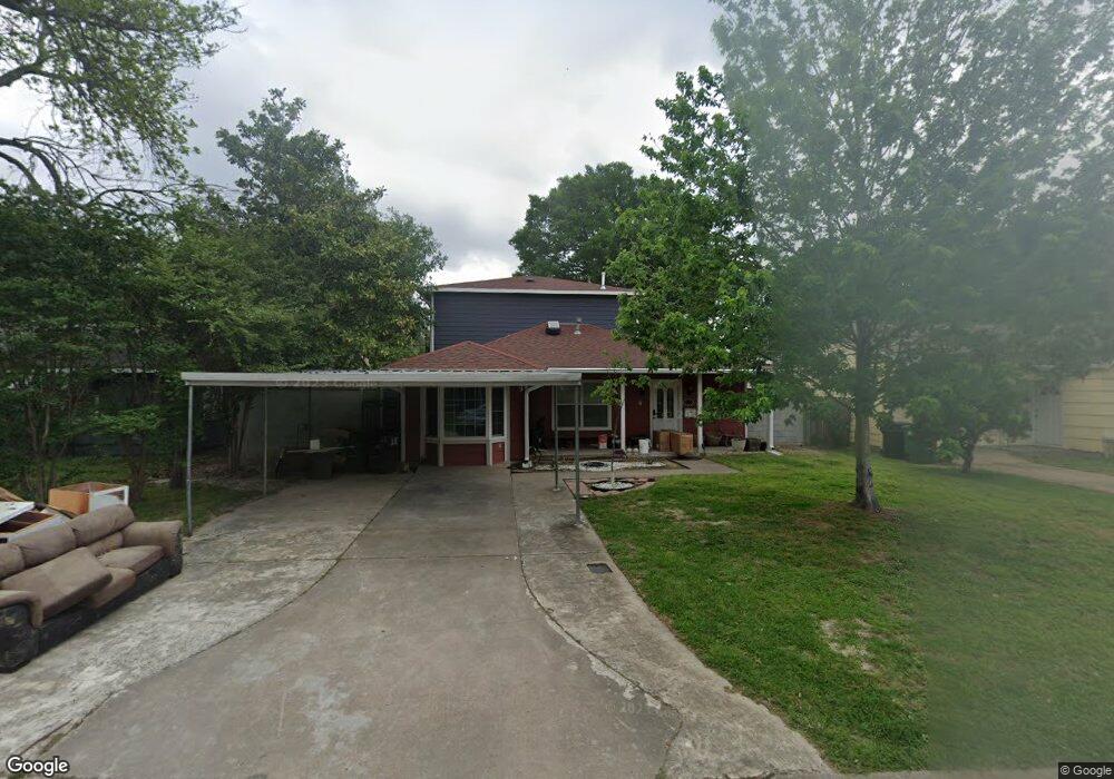
5322 Angelo St Houston, TX 77009
Northside Village NeighborhoodEstimated Value: $484,941 - $552,000
3
Beds
3
Baths
2,520
Sq Ft
$205/Sq Ft
Est. Value
About This Home
This home is located at 5322 Angelo St, Houston, TX 77009 and is currently estimated at $516,485, approximately $204 per square foot. 5322 Angelo St is a home located in Harris County with nearby schools including Jefferson Elementary School, Marshall Middle, and Northside High School.
Ownership History
Date
Name
Owned For
Owner Type
Purchase Details
Closed on
Sep 30, 1996
Sold by
Hud
Bought by
Zavalla John and Zavalla Michele
Current Estimated Value
Home Financials for this Owner
Home Financials are based on the most recent Mortgage that was taken out on this home.
Original Mortgage
$32,822
Outstanding Balance
$2,537
Interest Rate
7.96%
Mortgage Type
FHA
Estimated Equity
$513,948
Purchase Details
Closed on
Jun 4, 1996
Sold by
Leader Federal Bank For Svgs
Bought by
Hud
Create a Home Valuation Report for This Property
The Home Valuation Report is an in-depth analysis detailing your home's value as well as a comparison with similar homes in the area
Home Values in the Area
Average Home Value in this Area
Purchase History
| Date | Buyer | Sale Price | Title Company |
|---|---|---|---|
| Zavalla John | $33,103 | American Title | |
| Hud | -- | -- | |
| Leader Federal Bank For Svgs | $52,819 | -- |
Source: Public Records
Mortgage History
| Date | Status | Borrower | Loan Amount |
|---|---|---|---|
| Open | Zavalla John | $32,822 |
Source: Public Records
Tax History Compared to Growth
Tax History
| Year | Tax Paid | Tax Assessment Tax Assessment Total Assessment is a certain percentage of the fair market value that is determined by local assessors to be the total taxable value of land and additions on the property. | Land | Improvement |
|---|---|---|---|---|
| 2025 | $6,963 | $388,015 | $136,387 | $251,628 |
| 2024 | $6,963 | $476,928 | $136,387 | $340,541 |
| 2023 | $6,963 | $536,004 | $136,387 | $399,617 |
| 2022 | $8,499 | $437,300 | $117,667 | $319,633 |
| 2021 | $8,178 | $395,000 | $117,667 | $277,333 |
| 2020 | $7,725 | $344,698 | $117,667 | $227,031 |
| 2019 | $7,338 | $290,000 | $117,667 | $172,333 |
| 2018 | $3,932 | $208,081 | $96,273 | $111,808 |
| 2017 | $3,070 | $130,348 | $96,273 | $34,075 |
| 2016 | $2,791 | $125,000 | $90,925 | $34,075 |
| 2015 | $1,706 | $143,583 | $77,553 | $66,030 |
| 2014 | $1,706 | $91,220 | $53,485 | $37,735 |
Source: Public Records
Map
Nearby Homes
- 5510 Fulton St
- 408 Robert Lee Rd
- 213 Sylvester Rd
- 119 Sylvester Rd
- 5511 Enid St
- 1511 Cordell St
- 316 English St
- 216 Gale St
- 0000 W Cavalcade St
- 307 Gale St
- 5715 Enid St
- 5907 Nancy Ann St
- 1510 Walton St
- 1408 Enid St
- 1606 Walton St
- 1638 Tabor St
- 1630 1/2 Tabor St
- 1737 Tabor St
- 105 Delaney St
- 406 Gale St
- 5318 Angelo St
- 5326 Angelo St
- 5314 Angelo St
- 5402 Angelo St
- 5319 Karcher St
- 5315 Karcher St
- 5323 Angelo St
- 5310 Angelo St
- 5311 Karcher St
- 5319 Angelo St
- 5406 Angelo St
- 5327 Angelo St
- 5401 Karcher St
- 5401 Angelo St
- 5307 Karcher St
- 5307 Karcher St
- 5405 Karcher St
- 5311 Angelo St
- 5306 Angelo St
- 5410 Angelo St